/
7 th  Grade SS 		Name: 7 th  Grade SS 		Name:

7 th Grade SS Name: - PowerPoint Presentation

jane-oiler
jane-oiler . @jane-oiler
Follow
342 views
Uploaded On 2019-12-13

7 th Grade SS Name: - PPT Presentation

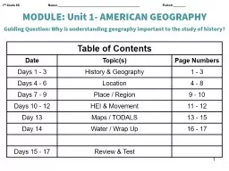
7 th Grade SS Name Period MODULE Unit 1 AMERICAN GEOGRAPHY Guiding Question Why is understanding geography important to the study of history Table of Contents Date Topics Page Numbers ID: 770214

states geography united map geography states map united objective maps north people environment unit hemisphere themes amp interaction human

Share:

Link:

Embed:

Download Presentation from below link

Download Presentation The PPT/PDF document "7 th Grade SS Name:" is the property of its rightful owner. Permission is granted to download and print the materials on this web site for personal, non-commercial use only, and to display it on your personal computer provided you do not modify the materials and that you retain all copyright notices contained in the materials. By downloading content from our website, you accept the terms of this agreement.


Presentation Transcript

7th Grade SS Name: Period: MODULE: Unit 1- AMERICAN GEOGRAPHY Guiding Question: Why is understanding geography important to the study of history? Table of ContentsDateTopic(s)Page NumbersDays 1 - 3History & Geography1 - 3Days 4 - 6Location4 - 8Days 7 - 9Place / Region9 - 10Days 10 - 12HEI & Movement11 - 12Day 13Maps / TODALS13 - 15Day 14Water / Wrap Up16 - 17Days 15 - 17Review & Test 1

Unit 1 EQ: Why is understanding geography important to the study of history?1. Geography of the America’s:Understanding geography is important to our understanding of the past and present. is linked to .To understand history, you must understand Geography.All of human history has taken place in our .2. Geography: Geography is the in which we all live and in which all past events have taken place. : landforms & geographical features on the Earth’s surface such as mountains, rivers, lakes, and deserts. : materials humans take from the environment to survive. Examples: Plants, Trees, Gold, Oil, Water, Sun : The condition of the Earth’s atmosphere at a given time and place. : The average weather of a place over a period of 20-30 years.Made up of temperature and precipitation (rain, snow)America’s Land & Water:Almost every landform, or physical feature, or geographic feature, is to be found somewhere in the United States. Physical features and geographic features are the same thing as landforms. These three words have the same meaning. A landform is a feature of the earth’s surface. Examples include bodies of water, mountains, valleys, deserts, and plains. Our rivers, lakes, and other bodies of water are essential parts of our country. They supply water for drinking and farming and, in some cases, for running power plants. They are also natural highways upon which enormous amounts of goods are moved every year. STOP CRQ: List examples of different landforms found in Upstate New York: 2

3Unit 1 EQ Objective 1: What are the five themes of Geography? Five Themes Rap Jeanie RobinsonHere's a basic tool what can it be.It's the five themes of geography.Location and Place and Movement too,What can Environments and Regions do?What can they do?What can they do?They can tell us about our world you know.Like where is a place and how can I go.What is it like? Is it hot or cold?Hot or cold.Hot or cold.Do I travel on a river? or trek through the snow?Can a take a plane or a car or a boat?Do I wear a pair of shorts or a big heavy coat?How do I know?How do I know?They tell you all the answers don't you see?They're the five themes of geography!Geography, GEOGRAPHY! 

3. LOCATION: A. : Compared to other places (variable)Changes dependent upon where you’re comparing it to. MilesDistanceDirection B. : exact location on Earth (Fixed)Doesn’t changeLatitude/LongitudeHemispheresGrid SystemAddress4. LATITUDE: 5. LONGITUDE: 4Unit 1 EQ, Objective 2: How do latitude and longitude help people to locate places in the world?CoordinateIntersecting latitude and longitude linesHouston (29°N, 95°W)OrHouston (95°W, 29°N)

World Map5Legend:Equator Prime MeridianLatitude LinesLongitude Lines Unit 1 EQ Objective 2: How do latitude and longitude help people to locate places in the world?

DIRECTIONS: Answer the following questions using the Maps in the textbook What is the name for 0° latitude line? What is the name for 0° longitude line? To measure distance north and south of the equator, you would use lines of To measure distance east and west of the Prime Meridian, you would use lines of Look at Map on Page A-9 If you were at 60°N, 100°E, on which continent would you be? Look at Map on Page A-9 If you were at 15°N, 25°E in which country would you be? Look at Map on Page A-3 What city is located at 40°N, 93°W? Look at Map on Page A-3 What is the capital of the state you are in if you were at 35°N, 110°W Look at Map on Page A-4. If you were at 40°N, 100°W which region of the United States would you be in? 6Unit 1 EQ Objective 2: How do latitude and longitude help people to locate places in the world?

● The United States is part of .● North America is one of the continents on the Earth.1. 2. 3. 4. 5. 6. 7. 1273564GLUE CONTINENTS FOLDABLE HERE75The United States is a country on the North American continent. Not counting Alaska and Hawaii, the United States measures about 2,500 miles east to west and 1,500 miles north to south. The Continental United States is bordered on the north by Canada, on the south by Mexico and the Gulf of Mexico, on the east by the Atlantic Ocean, and on the west by the Pacific Ocean. Unit 1 EQ Objective 3: What different types of maps would people use? 6. AMERICA’S LOCATION:

HEMISPHERES: WHERE ARE YOU?DIRECTIONS : Answer the following questions based on the globes and your geographic knowledge. The United States is in the Northern Hemisphere, the half of the earth north of the equator. The United States is also in the Western Hemisphere, the half of the earth west of Europe and Africa. The United States, along with Canada and Mexico, makes up North America. In addition, Central America and South America are part of the Western Hemisphere. Until about 500 years ago, mapmakers did not know that the Western Hemisphere existed. A line from the North Pole to the South Pole divides Earth into the Hemisphere and Hemisphere.Both North and South America are in the Hemisphere.Both Africa and Europe are in the Hemisphere.The equator divides the globe into the and hemispheres.People in the U.S. live in the and hemispheres.8America’s location is in the and Hemisphere’s. In size, the United States is the 4th largest nation in the world. More than 285 million Americans live on the more than 3.6 million square miles that our country covers.Unit 1 EQ Objective 1: What are the five themes of Geography?

7. PLACE: Describes an area’s physical and human features. It is the environment in which we live. A. PHYSICAL FEATURES: B. HUMAN/ CULTURAL FEATURES 9Unit 1 EQ Objective: What are the five themes of Geography?LANDFORM

10 Unit 1 EQ Objective: What are the five themes of Geography? REGION: ________________________________________________________________________________________________________ClimateLocationBeliefsLanguagesEthnicity/Race__ ____________________ ____________________ ___________________ __ ___________________ __ ___________________ There are 5 basic sections/ Regions in the United States. These include the Northeast, Southeast, Midwest, Southwest, and West. Not only can the United States be broken down into sections, but it can be broken down into land regions. SHADE and CREATE a LEGEND

9. Human Environment Interaction:ADAPT - People adapt to the environment by ___________________ ____ ____ ________ ________ in order to surviveMODIFY - People change the environment by __________________ ____________ it. ●As humans, we can either change our environment, or we have to change to fit into it. Movement: 11Unit 1 EQ 1 Objective: What are the five themes of Geography?

12 Comic Instructions – HEI FOLDABLE 1. In the 1st slide design a title and drawing for Human-Environment Interaction. (15 points)2. In the 2nd slide explain to the reader what a human-environment interaction is, using examples you have learned in class. (20 points)In boxes 3,4, Identify TWO instances of Human-Environment Interaction. The pictures should be informational. You want to tell the reader basic information about this interaction. (10 points each = 20 points total)On the back of the comic List 2 pros and 2 cons for each interaction. These can be bulleted. (20 points each interaction = 40 points total)In the last box, write your name. You may also decorate this pane as well (5 points).FOR TEACHER USE: Box 1(15 pts)Box 2(20 pts)Box 3(30 pts)Box 4(30 pts)Box 5(5 pts)TitleImageDefine HEI in your own wordsModificationIMAGEExplainPros & ConsAdaptationIMAGEExplainPro & Con Name Date Class Period

11. MAPS: TYPES OF MAPS: There are 2 main types of maps; physical and political maps. 13 A. Physical MapB. Political MapUnit 1 EQ 3 Objective: What different types of maps do people use?

12. PARTS OF A MAP: All maps have 5 basic parts. TODALS 14 Unit 1 EQ 3 Objective: What different types of maps do people use?LABEL THE MAP PARTS ON THE MAP TO THE RIGHT: TODALS2000A. Marzus

1. What is the title of the map? ________________________________________________________________________________________________________________________2. Draw the pattern that is used to show the following information: a. Peak: c. State Highway: b. Pass: d. Camp: 3. What is the part of the map called that is used to find this information? __________________________________________________________________________________________________________________________________________________ 4. About how many miles is it from Tioga Pass to Tuolumne Meadows? __________________________________________________________________________________________________________________________________________________5. What is the part of the map called that you used to determine this distance?__________________________________________________________________________________________________________________________________________________MAP SKILLS WORKSHEET: THE PARTS OF A MAPDIRECTIONS: The map below provides information about the Yosemite National Park. Study the map and answer the questions. 6. In what direction would you be traveling if you went from Mono Pass to White Wolf Lodge? ___________________________________________________________________________________________________________________________________________________________________________________________________________7. What part of the map is used to tell direction? __________________________________________________________________________________________________________________________________________________________________________________________________________________________________________________15

16 12. WATER: How do rivers and lakes benefit the economy of the United States?______________________________________________________________________________________________________________________________ Unit 1 EQ 4 Objective: How do rivers and lakes benefit the economy of the United States?

17 Unit 1 EQ 4 Objective: How do rivers and lakes benefit the economy of the United States? The Great Lakes & St. Lawrence Sea WayH.O.M.E.S

18

19____ ____ ________________________7 Continents5 Oceans

20