PPT-GIS In Water Resources C E 394K Impact of Floods to the Bridge Deterioration Process
Author : jane-oiler | Published Date : 2019-11-03
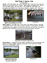
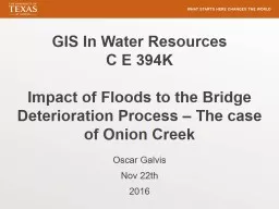
GIS In Water Resources C E 394K Impact of Floods to the Bridge Deterioration Process The case of Onion Creek Oscar Galvis Nov 22 th 2016 Problem Floods Impact Bridge
Presentation Embed Code
Download Presentation
Download Presentation The PPT/PDF document "GIS In Water Resources C E 394K Impact..." is the property of its rightful owner. Permission is granted to download and print the materials on this website for personal, non-commercial use only, and to display it on your personal computer provided you do not modify the materials and that you retain all copyright notices contained in the materials. By downloading content from our website, you accept the terms of this agreement.
GIS In Water Resources C E 394K Impact of Floods to the Bridge Deterioration Process: Transcript
Download Rules Of Document
"GIS In Water Resources C E 394K Impact of Floods to the Bridge Deterioration Process"The content belongs to its owner. You may download and print it for personal use, without modification, and keep all copyright notices. By downloading, you agree to these terms.
Related Documents