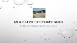
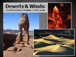
/
Tectonics, Tsunamis, and Sand: Creating the Ten Mile Dunes, Fort Bragg, California Tectonics, Tsunamis, and Sand: Creating the Ten Mile Dunes, Fort Bragg, California

Tectonics, Tsunamis, and Sand: Creating the Ten Mile Dunes, Fort Bragg, California - PowerPoint Presentation

lois-ondreau
lois-ondreau . @lois-ondreau
Follow
350 views
Uploaded On 2018-11-07

Tectonics, Tsunamis, and Sand: Creating the Ten Mile Dunes, Fort Bragg, California - PPT Presentation

ABSTRACT An extensive area of coastal sand dunes at the north end of Northern Californias MacKerricher State Park lies atop a differentially subsided section of Earths crust that preserves ID: 719437

sand fig ten fault fig sand fault ten mile north section organic river layers sea sandy zone south beach

Share:

Link:

Embed:

Download Presentation from below link

Download Presentation The PPT/PDF document "Tectonics, Tsunamis, and Sand: Creating ..." is the property of its rightful owner. Permission is granted to download and print the materials on this web site for personal, non-commercial use only, and to display it on your personal computer provided you do not modify the materials and that you retain all copyright notices contained in the materials. By downloading content from our website, you accept the terms of this agreement.


Presentation Transcript

Slide1

Tectonics, Tsunamis, and Sand: Creating the Ten Mile Dunes, Fort Bragg, California

ABSTRACT:

An

extensive area of coastal sand dunes at the north end of Northern California’s MacKerricher State Park lies atop a differentially subsided section of Earth’s crust that preserves

a Late Pleistocene to Holocene

history of recurring tectonic and tsunami activity. The block dips slightly to the north-northwest, extends an unknown distance offshore, and is separated from coastal terraces immediately to the north by a zone of en echelon faults that is partly occupied by the Ten Mile River. Movement within the fault zone has offset three

streams, one

a likely

paleochannel

of the Ten Mile

River;

uplifted the area to the north of the dunes and river; and accommodated subsidence to the south. The northern uplift is revealed

by the presence of raised

wave-cut notches,

the appearance of steep

bedrock sea cliffs, isolated sea stacks, and a generally higher and steeper landscape. The ramp formed by the subsided block has facilitated onshore movement of sand and the formation of the Ten Mile Dunes. At its south end, the block is broadly folded and cut by a high-angle, east-dipping, reverse fault (N5W/70-80E) displaying as much as 3.5 meters of accumulated vertical offset. Averaged slickensides indicate N15E/35 relative displacement. The subsided section extends offshore below the minus tide level and includes massively bedded and laminated layers of sand alternating with organic-rich marsh and terrestrial deposits. Contacts between the many layers are generally sharp to diffuse across a narrow zone of a few centimeters. Several of the layers entomb well-preserved life-position tree stumps and assorted herbaceous material. Convoluted laminations, water-escape features, and flame structures occur throughout the section and attest to rapid deposition and burial by waterborne sediment. Although several of the features mentioned here may be interpreted as storm related, the existence of proximate faults and evidence of tectonic displacement strongly argue for a tsunami origin. This preliminary investigation and analysis suggests that the coastal strand in the Ten Mile area is occasionally rocked by strong earthquakes generated on nearby faults, and suffers the impact of locally generated tsunamis resulting from coseismic seafloor subsidence.3

David J. Springer, Springer Consulting, 532 West Street, Fort Bragg, California fbgeodude@yahoo.com

Figures

5 and 6 Three offset stream channels (arrows) lie just north of the Ten Mile river and dunes. None of the channels possesses a drainage basin commensurate with its size. Channel offset is the result of dextral slip within a zone of en echelon faults (fig.9). The widest of the three channels is believed to be a paleochannel of the Ten Mile River.

Fig. 1

Several sea cliffs and sea stacks immediately north of the Ten Mile River preserve one or more uplifted wave-cut notches. The notch seen here, sits ~ 2.25 m above the wave attack zone, the zone of maximum abrasion.

Offset streams

:

Uplifted wave-cut notches:

Steep bedrock sea cliffs & isolated stacks:

Fig. 4 Two hundred meters north of the mouth of Ten Mile River several sea stacks have been uplifted and isolated from the wave action that carved them. The stacks now are surrounded by sandy beach deposits.

Fig. 3

Steep bedrock

sea

cliffs, 10

to

20 m high, abruptly dominate the coastline immediately north of Ten Mile River. To the south, cliffs are absent for ~6 km and the shoreline consists of open sandy beach and active dunes (see fig. 7).

NNW dipping bedrock “ramp”:

Fig. 7 At the south end of the Ten Mile dune field, the bedrock platform and overlying sedimentary section dip NNW, eventually disappearing beneath sandy beach deposits. Bedrock emerges ~ 6 km to the north to form 10 to 20-meter-high sea cliffs and the north embankment of the Ten Mile River estuary.

Northern Fault Zone

S

edimentary section

fault

zone

Fig. 22

The uppermost layer of the sedimentary section is a sandy marsh deposit containing multiple small tree stumps (< 15 cm dia.). Several of the stumps are partially uprooted and have a pronounced landward lean. A

14C date on one of the stumps indicates an age of 2,450 +/- 60 BP.

Fig. 8

Fig. 9

References

Fig. 10 A recent trace of the reverse fault was exhumed from beneath modern beach deposits at the south end of the Ten Mile dune field during the winter of 1997-98. East of the fault (U) a 2-meter-thick clay and crushed-rock gouge zone was revealed, while to the west (D), older beach sand was exposed.

Fig. 12 View south along the fault. The east dip of the fault plane is seen in uplifted bedrock at the bottom left and in the middle distance where the fault cuts Pleistocene to Holocene beach deposits.

Fig. 13 Two fault planes cut Pleistocene to Holocene beach deposits at the south end of the fault. Fluidized blue sand has injected along the western plane and out along laminations in the modern beach sand. Each of the subparallel planes offsets an underlying layer of sandy marine gravel more than 0.5 m.

1. Lawson, Andrew C., complier, 1908, The California Earthquake of April 18,1906: Report of the State Earthquake Investigation Commission, vol. 1: Carnegie Institute of Washington, 87, p. 174-175.2. Matsumoto, D., et al., 2008, Truncated flame structures within a deposit of the Indian Ocean Tsunami: evidence of syn-sedimentary deformation: Sedimentology, vol. 55, no.6, p. 1559-1570.3. Springer, David J., 1999, Evidence of Late Pleistocene to Holocene earthquakes and coseismic subsidence preserved near Fort Bragg,Ca: GSA Abstracts with Programs, Cordilleran Section, vol.31, no.6, p.A-97.4. Yasuda, N. and Sumita, I., 2014, Shaking conditions required for flame structure formation in a water-immersed granular medium: Progress in Earth and Planetary Science, Open Access, http://www.progearthplanetsci.com/content/1/1/13.

Fig. 24 The pine stump in fig. 23 appears here at water’s edge. The stump, multiple cobbles, and two large (>1m) gray angular boulders (upper right corner of the photo) are partially encased in the dark sandy layer crossing the image. The presence of the many stones and sand, coupled with the excellent preservation and inland tilt of the stump, all in a tectonically subsided setting, strongly suggests the work and energy of a tsunami.

Fig. 23

A pine tree rooted in a gray sandy paleosol was snapped off and its stump enclosed in a low oxygen environment, resulting in excellent preservation. The enclosing sediment is a brown to black organic sand. The stump is partially uprooted, leans inland at ~35 degrees, and yields a 14C date of 2,760 +/-70 BP.

Fig. 19 Fluidized fine silt and sand moved up along numerous small pipes, dikes and sills to form the white band seen here and in figs 16 and 18. As in figure 18, organics have collapsed into a small chamber that formed below the organic sequence.

Fig. 17 Closeup of seismically disrupted organic layers seen in fig.16. Each organic layer is enclosed by layers of massive to chaotically laminated sand. The flame structures and overall pattern of the organics verge to the north. The middle sand layers contain considerable quantities of loose herbaceous material, mostly monocotyledons.

Fig. 18 Sediment has collapsed into two cavities that formed below the disrupted organics as a result sand blow activity. Capping the section at the top left is a mound of pale gray-brown sand representing a more recent venting episode. Lawson (1908) reported several sand blows occurred in the vicinity of the Ten Mile River during the 1906 San Francisco earthquake.

Fig. 21 Many of the sand layers in the sedimentary sequence contain highly convoluted to chaotic laminae. Convolution is the result of applied shear stress, possibly resulting from drag exerted by an overriding wave. In general, the disturbed strata are medium to coarse grained and contain multiple lag deposits. The laminated unit in this photo is capped by a thin organic mud.

Fig. 14

Lower beds of the sedimentary section are thick (0.2 to 0.5 m) accumulations of silty organics separated by layers of heavily rooted pale gray sand (10 to 20 cm). The beds record a history of repeated marsh development and burial. The lowest organic layer, with a 14C age of 29,000 BP, rests on a bed of iron-stained sandy marine gravel that marks the base of the Late Pleistocene to Holocene sequence.

(The fault may be an oblique reverse or scissor fault displaying increased displacement to the north.)

Fig. 11 Vertical offset of ~3.5 m was measured on this distinct layer of blue sand. The upper contact of the sand is visible near the top of the mudflow (arrow), while its cross-fault extension is seen in the foreground. The elongate ridge at the foot of the flow is oriented along fault strike.

U

D

Fig. 2

The larger of these two sea stacks displays two wave-cut notches.

One notch is ~1.5 m above intertidal, the other ~ 3.25 m above. Although the notches are evidence of uplift, the timing and number of events responsible are unknown.

Fig. 5

Fig. 6

N5W/70 - 80E reverse fault

Fig. 16

The middle of the section includes three highly disrupted organic-rich layers interposed with beds of sand. The presence of flame structures,

load casts and convolute laminae suggests episodes of rapid burial by water-borne sand followed by severe seismic shaking.

2,4

Fig. 15

Several life-position tree stumps are found in the

top portion of the sedimentary section. The stumps are rooted in silty to sandy

paleosols and encased in overlying organic-rich sand.

Fig. 20

In this

closeup of fig.19, the upward path of the fine white silt and sand is clearly discernable. During strong seismic events, the relatively impermeable organic layers likely impede upward movement of ground water, thereby promoting overpressure and the fluidization of underlying saturated sediment, which eventually is expelled to the surface.

Fig. 25

A

ctive parabolic dunes at the south end of the Ten Mile dune field. Evidence indicates the dune field formed as a result of tectonic subsidence

and that a portion of the sand has been moved onshore by tsunamis. The light-colored sea cliff extending north from the road washout in the middle

foreground

is the exposed edge

of the sedimentary

section described above. The location and strike of the reverse fault are indicated by the yellow arrow.

U

D

U

D