PPT-Land Navigation Identify Topographic Symbols
Author : luanne-stotts | Published Date : 2018-10-29
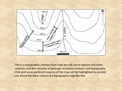
on a Military Map Action Identify Topographic Symbols on a Military Map Conditions Given a standard 150000 scale topographical map Standards Correctly identify
Presentation Embed Code
Download Presentation
Download Presentation The PPT/PDF document "Land Navigation Identify Topographic Sym..." is the property of its rightful owner. Permission is granted to download and print the materials on this website for personal, non-commercial use only, and to display it on your personal computer provided you do not modify the materials and that you retain all copyright notices contained in the materials. By downloading content from our website, you accept the terms of this agreement.
Land Navigation Identify Topographic Symbols: Transcript
Download Rules Of Document
"Land Navigation Identify Topographic Symbols"The content belongs to its owner. You may download and print it for personal use, without modification, and keep all copyright notices. By downloading, you agree to these terms.
Related Documents