/
Erosion and Deposition Erosion and Deposition

Erosion and Deposition - PowerPoint Presentation

myesha-ticknor
myesha-ticknor . @myesha-ticknor
Follow
611 views
Uploaded On 2016-10-29

Erosion and Deposition - PPT Presentation

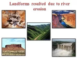
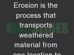
Water Erosion How Does Moving Water Cause Erosion Erosion by water begins with a splash of rain Some rainfall sinks into the ground Some evaporates or is taken up by plants The rest of the water runs off over the land surface ID: 481720

river water runoff erosion water river erosion runoff land called flows flood stream soil rock limestone sediment plain gullies

Share:

Link:

Embed:

Download Presentation from below link

Download Presentation The PPT/PDF document "Erosion and Deposition" is the property of its rightful owner. Permission is granted to download and print the materials on this web site for personal, non-commercial use only, and to display it on your personal computer provided you do not modify the materials and that you retain all copyright notices contained in the materials. By downloading content from our website, you accept the terms of this agreement.


Presentation Transcript

Slide1

Erosion and Deposition

Water ErosionSlide2

How Does Moving Water Cause Erosion?

Erosion by water begins with a splash of rain.

Some rainfall sinks into the ground.

Some evaporates or is taken up by plants.Slide3

The rest of the water runs off over the land surface.

Moving water is the major agent of the erosion that has shaped Earth’s land surface.Slide4

Runoff

As water moves over the land, it carries particles with it.

This moving water is called runoff.

When runoff flows in a thin layer over the land, it may cause a type of erosion called sheet erosion.

The amount of runoff in an area depends on five main factors.Slide5

The first factor is the amount of rain an area gets.

A second factor is vegetation. Grasses, shrubs, and trees reduce runoff by absorbing water and holding soil in place.

A third factor is the type of soil. Some types of soils absorb more water than others.Slide6

A fourth factor is the shape of the land. Steeply sloped land has more runoff than flatter land.

Finally, a fifth factor is how people use land. For example, a paved parking lot absorbs no water. All the rain that falls on it becomes runoff. Runoff also increases when farmers cut down crops, since this removes vegetation from the land.Slide7

Generally, more runoff means more erosion.

In contrast, factors that reduce runoff will reduce erosion.

Even though deserts have little rainfall they often have high runoff and erosion because they have few plants and thin soil.

In wet areas, runoff and erosion may be low because there are more plants to help protect the soil.Slide8

Stream Formation

Because of gravity, runoff and the material it contains flow downhill.

As this water moves across the land, it runs together to form rills gullies, and streams.Slide9

Rills and Gullies

As runoff travels, it forms tiny grooves in the soil called rills.

When many rills flow into one another, they grow larger, forming a gully.

A gully is a large groove, or channel, in the soil that carries runoff after a rainstorm.Slide10

As water flows through gullies, it moves soil and rocks with it, this enlarging the gullies through erosion.

Gullies only contain water during a rainstorm and for a short time after it rains.Slide11

Streams and Rivers

Gullies join together to form a larger channel called a stream.

A stream is a channel along which water is continually flowing down a slope.

Unlike gullies, streams rarely dry up.Slide12

Small streams are also called creeks or brooks.

As streams flow together, they form larger and larger bodies of flowing water.

A large stream is often called a river.Slide13

Tributaries

A stream grows into a larger stream or river by receiving water from tributaries.

A tributary is a stream or river that flows into a larger river.

For example, the Missouri and Ohio rivers are tributaries of the Mississippi River.

A drainage basin, or watershed, is the area from which a river and its tributaries collect their water.Slide14

Raindrops Falling Lab

Homework is pages

215-221Slide15

Water Erosion

Many rivers begin on steep mountain slopes.

Near their source, these rivers can be fast-flowing and generally follow a straight, narrow course.

The steep slopes along the river erode rapidly, resulting in a deep, V-shaped valley.Slide16

As a river flows from the mountains to the sea, it forms many features.

Through erosion, a river creates valleys, waterfalls, flood plains, meanders, and oxbow lakes.Slide17

Waterfalls

Waterfalls may occur where a river meets an area of rock that is very hard and erodes slowly.

The river flows over this rock and then flows over softer rock downstream.

Softer rock wears away faster than harder rock.Slide18

Eventually a waterfall develops where the softer rock was removed.

Areas of rough water called rapids also occur where a river tumbles over hard rock.Slide19

Flood Plain

Lower down on its course, a river usually flows over more gently sloping land.

The river spreads out and erodes the land, forming a wide river valley.

The flat, wide area of land along a river is a flood plain.Slide20

On a wide flood plain, the valley walls may be kilometers away from the river itself.

A river often covers its flood plain when in overflows its banks during a flood.

When the flood water finally retreats, it deposits sediment as new soil.

This makes a river valley fertile.Slide21

Meanders

A river often develops meanders where it flows through easily eroded rock or sediment.

A meander is a

looplike

bend in the course of a river.

As the river winds from side to side, it tends to erode the outer bank and deposit sediment on the inner bank of a bend.

Over time, a meander becomes more curved.Slide22

Because of the sediment a river carries, it can erode a very wide flood plain.

Along this part of a river’s course, its channel may be deep and wide.

The southern stretch of the Mississippi River meanders on a wide, gently sloping flood plain.Slide23

Oxbow Lakes

Sometimes a meandering river forms a feature called an oxbow lake.

An oxbow lake is a meander that has been cut off from the river.

An oxbow lake may form when a river floods.Slide24

During the flood, high water finds a straighter route downstream.

As the flood waters fall, sediments dam up the ends of a meander, forming an oxbow lake.Slide25

Water Deposition

As water moves, it carries sediment with it.

Any time moving water slows down, it drops, or deposits, some of the sediment.

In this way, soil can be added to a river’s flood plain.Slide26

As the water slows down, large stones quit rolling and sliding.

Fine particles fall to the river’s bed as the river flows even more slowly.

Deposition creates landforms such as alluvial fans and deltas.Slide27

Deltas

A river ends its journey when it flows into a still body of water, such as an ocean or a lake.

Because the river water is no longer flowing downhill, the water slows down.

At this point, the sediment in the water drops to the bottom.Slide28

Sediment deposited where a river flows into an ocean or lake builds up a landform called a delta.

Deltas can be a variety of shapes.

The delta of the Mississippi River is an example of a type of delta called a “bird’s foot” delta.Slide29

Alluvial Fans

Where a stream flows out of a steep, narrow mountain valley, the stream suddenly becomes wider and shallower.

The water slows down.

Here sediments are deposited in an alluvial fan.Slide30

An alluvial fan is a wide, sloping deposit of sediment formed where a stream leaves a mountain range.

As its name suggests, this deposit is shaped like a fan.Slide31

Groundwater Erosion

When rain falls and snow melts, not all of the water evaporates or becomes runoff.

Some water soaks into the ground.

There it fills the openings in the soil and trickles into cracks and spaces in layers of rock.Slide32

Groundwater is the term geologists use for this underground water.

Like running water on the surface, groundwater affects the shape of the land.Slide33

Groundwater can cause erosion through a process of chemical weathering.

Rainwater is naturally acidic.

In the atmosphere, water combines with carbon dioxide to form a weak acid called carbonic acid.Slide34

Carbonic acid can break down limestone.

Groundwater containing carbonic acid flows into any cracks in the limestone.

Then some of the limestone dissolves and is carried away in a solution of water.Slide35

This process gradually hollows out pockets in the rock.

Over time, these pockets develop into large holes underground, called caves or caverns.Slide36

Cave Formations

The action of carbonic acid on limestone can also result in deposition.

Inside limestone caves, deposits called stalactites and stalagmites often form.

Water containing carbonic acid and calcium from limestone drips from a cave’s roof.Slide37

Carbon dioxide escapes from the solution, leaving behind a deposit of calcite.

A deposit that hangs like an icicle from the roof of a cave is known as a stalactite.

Slow dripping builds up a cone-shaped stalagmite from the cave floor.Slide38

Karst Topography

In rainy regions where there is a layer of limestone near the surface, groundwater erosion can significantly change the shape of the land.

Streams are rare, because water easily sinks down into the weathered limestone.

Deep valleys and caverns are common.Slide39

If the roof of a cave collapses because of the erosion of the underlying limestone, the result is a depression called a sinkhole.

This type of landscape is called karst topography after a region in Eastern Europe.Slide40

Erosion Cube Lab

Homework is pages

222-227