PPT-Points along contour where meridional PV gradient reversal
Author : myesha-ticknor | Published Date : 2017-06-21
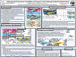
Similar to Postal and Hitchman 1999 w 2556 km p 12823 km A rea 8569380 km 2 Similar but more inclusive than Wernli and Sprenger 2007 Subtropical PV Streamer
Presentation Embed Code
Download Presentation
Download Presentation The PPT/PDF document "Points along contour where meridional PV..." is the property of its rightful owner. Permission is granted to download and print the materials on this website for personal, non-commercial use only, and to display it on your personal computer provided you do not modify the materials and that you retain all copyright notices contained in the materials. By downloading content from our website, you accept the terms of this agreement.
Points along contour where meridional PV gradient reversal: Transcript
Download Rules Of Document
"Points along contour where meridional PV gradient reversal"The content belongs to its owner. You may download and print it for personal use, without modification, and keep all copyright notices. By downloading, you agree to these terms.
Related Documents