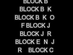
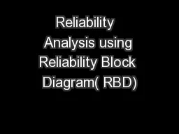
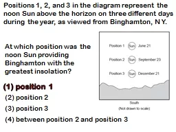
a landscape region Which stream drainage pattern would most likely develop at the surface of this region The sediments that CANNOT be eroded by a stream traveling at a velocity of 100 centimeter ID: 679697
Download Presentation The PPT/PDF document "The block diagram shows" is the property of its rightful owner. Permission is granted to download and print the materials on this web site for personal, non-commercial use only, and to display it on your personal computer provided you do not modify the materials and that you retain all copyright notices contained in the materials. By downloading content from our website, you accept the terms of this agreement.
Slide1
The block diagram
shows
a landscape region.
Which stream drainage pattern would most likely develop at the surface of this region?Slide2
The sediments that CANNOT
be eroded by a stream traveling at a velocity of100 centimeter per second are boulders only
(2) pebbles, sand, silt, and clay(3) pebbles and sand only(4) boulders and cobbles onlySlide3
Why is the depth of water 20 feet from point
A different from
the depth of water 20 feet from point B?P.S./E. Sci.–Jan. ’10
The stream carries clay, pebbles, sand, and silt. Listthese sediments in the most likely order of deposition from point C to point D.Slide4
The letters
A through D in the cross section
represent four of the processes that are part of the water cycle.Which table correctly matches each letter with the process that it represents?Slide5
The cross section
shows layers of
sediments deposited in a region of Wisconsin that has experienced several periods of glaciation.Descriptions of the sediments in layers A
through F are included.
Which two layers of sediments were probably
deposited directly by glaciers
?
(
1)
A
and
D
(
3)
C
and
E
(
2)
B
and
F
(4) D and ESlide6
Which characteristic would most likely remain constant when a limestone cobble is subjected to extensive abrasion?
(1) shape (3) volume
(2) mass (4) compositionSlide7
Which graph best represents the relationship between the slope of a river and the particle size that can be transported by that river?Slide8
Which cross section best shows the pattern of sediments deposited by
a stream asit enters
an ocean?Slide9
The diagram
represents 3 identical
beakers filled to the same level with spherical beads.If the packing of the beads within each beaker is the same, which graph best represents the porosity
within each beaker?Slide10
The diagram represents four identical columns filled with sediments of uniform shape and packing. They are placed over empty glass beakers.
If water is poured into each column, which column is the least permeable to infiltration?
1) A 2) B 3) C 4) D Slide11
The diagram represents four identical columns filled with sediments of uniform shape and packing. They are placed over empty glass beakers.
If water is poured into each column, which will exhibit the least retention of water?
1) A 2) B 3) C 4) D Slide12
Which agent of erosion was primarily responsible for forming the long, narrow, U-shaped valleys in the Finger Lakes region of New York State? Wind
(2) Landslides(3) meandering streams(4) continental glaciersSlide13
Which factor will increase the amount of chemical weathering in an environment?
air temperature decreases and precipitation decreases(2) air temperature decreases and precipitation increases(3) air temperature increases and precipitation decreases
(4) air temperature increases and precipitation increasesSlide14
What evidence shown at location A
suggests that the channel in the bedrock waseroded by running water in the ancient past?
RIVER!Slide15
Which landscape surface resulted primarily from erosion by glaciers?Slide16
The map shows a meandering stream. Points A, B, C, and D represent locations
along the stream bottom.
At which location is the greatest amount of sediment most likely being deposited? (1) A (3) C
(2) B (4) DSlide17
The map shows a meandering stream. Points A, B, C, and D represent locations
along the stream bottom.
At which location is the greatest amount of sediment most likely being eroded? (1) A (3)
C (2) B (4) DSlide18
The diagram represents four identical columns filled with sediments of uniform shape and packing. They are placed over empty glass beakers.
If water drains from each column, which will require the most time for drainage?
1) A 2) B 3) C 4) D Slide19
The diagram represents four identical columns filled with sediments of uniform shape and packing. They are placed over empty glass beakers.
If each beaker is filled with water, which column will display the
greatest capillarity?1) A 2) B 3) C 4) D Slide20
The cross section shows soil layer X,
which was formed from underlying bedrock.
Which change would most likely cause soil layer X to
increase in thickness?(1) a
decrease in
slope
(2) a decrease in
rainfall
(3) an increase in biologic
activity
(4) an increase in air pressureSlide21
A stream flowing at a velocity of 200
cm/
sec is transporting sediment particles ranging in size from clay to cobbles. Which particles will be deposited by the stream if its velocity decreases to 100 cm/sec?cobbles, only(2) cobbles and some pebbles, only
(3) cobbles, pebbles, and some sand, only(4) cobbles, pebbles, sand, silt, and claySlide22
Old Forge and Watertown, located at nearly thesame latitude in New York State, have verydifferent landscapes. Which factor is primarily
responsible for these landscape differences? (1) average annual temperature
(2) average annual precipitation (3) bedrock structure (4) soil characteristicsSlide23
Sediments found in glacial moraines are best described as(1) sorted and layered(2) sorted and not layered
(3) unsorted and layered(4) unsorted and not layeredSlide24
The data table at left shows the diameters of three particles made of the same uniform material. These particles were carried by a stream into a lake.
Indicate the expected pattern of deposition of the three particles by placing the letters
A, B, and C in the appropriate boxes along the lake bottom.BA
C
WHY?Slide25
The table shows the density of four mineral samples.
If the shape and size of the four mineral samples are the same, which mineral will settle most slowly in water? (1) cinnabar (3) quartz (2) magnetite (4) sideriteSlide26
Which characteristic would most likely remain constant when a limestone cobble is subjected to extensive abrasion?
(1) shape (3) volume
(2) mass (4) compositionSlide27
The sediments that CANNOT
be eroded by a stream traveling at a velocity of100 centimeter per second are boulders only
(2) pebbles, sand, silt, and clay(3) pebbles and sand only(4) boulders and cobbles onlySlide28
The map below shows a meandering stream. Points A, B, C, and D represent locations alongthe stream bottom.
At which location is the greatest amount of sediment most likely being eroded?
(1) A (3) C (2) B (4) DSlide29
The block diagrams below show two landscape regions labeled A and B.
What is the most probable cause of the difference in surface features between A and B?A is the result of a humid climate, while B is the result of a dry climate.
(2) A is at a high elevation, while B is located at sea level.(3) A is a plateau region, while B is a mountainous region.(4) A is composed of igneous bedrock, while B is composed of sedimentary bedrock.
landscapesSlide30
The map below shows the large delta that formed as the Mississippi River emptied into the Gulf of Mexico.
Which process was primarily responsible for theformation of the delta?
(1) glacial erosion(2) cementation of sediment(3) deposition of sediment(4) mass movementSlide31
Base your answers to questions 48 through 50 on the map of Long Island, New York.
AB, CD, EF, and
GH are reference lines on the map.48 Which agent of erosion transported the sediments
that formed the moraines shown on the map?
(
1) water
(
3) ice
(
2) wind
(
4) mass movementSlide32
49 The cross
section below represents the
sediments beneath the
land
surface
along one of
the reference lines shown on the map.
Along
which reference line was the cross section taken
?
(1)
AB
(
2)
CD
(
3)
EF
(4
)
GHSlide33
50 A major
difference between sediments in
the outwash and
sediments
in
the
moraines
is that the sediments deposited in the outwash are
(1) larger (
3) more
angular
(2) sorted
(
4) olderSlide34
The cross section shows layers of soil. Which two processes produced the layer of dark brown to black soil?
(1) melting and solidification
(2) weathering and biologic activity(3) erosion and uplifting (4) compaction and cementationSlide35
How fast must a river move to erode an average sized piece of sand?
Approx. 2 cm/
sSlide36
How fast must a river move to erode a 0.07 cm piece of sand?
Approx. 4 cm/
sSlide37
The map below shows a meandering stream. Points A, B, C, and D represent locations alongthe stream bottom.
At which location is the greatest amount of sediment most likely being deposited? (1) A (3) C (2) B (4) DSlide38
The photograph below shows farm buildings partially buried in silt.
Which
erosional agent most likely piled the silt against these buildings?(1) glacial ice (3) wind(2) ocean waves (4) mass movementSlide39
The sedimentary rocks conglomerate and breccia are shown belowThey are the same in most respects, except for the fact that one was formed in water and the other was not. Which formed in water and how can you tell?
(1) Breccia, because it has angular fragments (2) Conglomerate, because it has angular fragments
(3) Breccia, because it has rounded fragments (4) Conglomerate, because it has rounded fragments
Conglomerate
Breccia
ABRASION
!Slide40
Each of the rock particles below has the
same density and volume. Which particle will
most likely settle at the fastest rate in moving water?Slide41
The landscape diagram below shows a fan-shapedpattern of sediment deposits.
The fan-shaped pattern of these sediments is most likely the result of deposition by
(1) glacial ice (3) running water (2) ocean waves (4) prevailing windsSlide42
The sediments that
can be eroded by a stream traveling at a velocity of1 centimeter per second are boulders only
(2) pebbles, sand, silt, and clay(3) sand and silt only(4) sand, silt and claySlide43
A student classified the rock as sedimentary.
Which observation about the rock best supportsthis classification?(1) The rock is composed of several minerals.
(2) The rock has a vesicular texture.(3) The rock contains fragments of other rocks.(4) The rock shows distorted and stretched pebbles
.Slide44
The diagram shows a laboratory stream table. A mixture of sediment was placed on the stream table. A short time after the faucet was turned on, a deposit of sediment began forming at location
X at the lower end of the stream table.What is the name of the feature forming at location
X? (1) V-shaped valley (2) meander (4) floodplain(3) deltaSlide45
The diagrams below represent four different examples of one process that transports sediments. Which process is shown in these diagrams?
chemical weathering (3) faulting (2) uplifting (4) erosion
“mass wasting”Slide46
Which type of weathering is most common where the average yearly temperature is
20°C and the average yearly precipitation is 45 cm? moderate chemical weathering(2) very slight weathering
(3) moderate chemical weathering with frost action(4) slight frost actionThe amount of chemical weathering will increase ifair temperature decreases and precipitation decreases
(2) air temperature decreases and precipitation increases(3) air temperature increases and precipitation decreases(4) air temperature increases and precipitation increasesSlide47
The map below shows a meandering river. Points
A and B are locations on the banks of the river.What are the dominant processes occurring at
locations A and B?(1) deposition at location A; erosion at location B(2) erosion at location A; deposition at location B
(3) deposition at both locations A and B(4) erosion at both locations A and B
Outside!Slide48
The photograph here shows an arch of rock located in the western United States.How did the arch most likely form?
1) The bedrock in the arch was more resistant to weathering and erosion than the surrounding bedrock that was removed. 2) An earthquake forced bedrock upward into the shape of an arch. 3) Sand and gravel were deposited and compacted in the shape of an arch. 4) An underground glacier tunneled through the bedrock.Slide49
The demonstration shown in the diagram indicates that powdered limestone reacts faster than a single large piece of limestone of equal mass when both are placed in acid.
The most likely reason powdered limestone reacts faster is that it has1) less total volume 3) more total surface area2) more chemical bonds 4) lower density
The “inside” got more exposedSlide50Slide51
The largest sediment particles that can be transported by a stream traveling at a velocity of
100 centimeters per second are boulders(2) cobbles
(3) pebbles(4) sandSlide52
A stream flowing at a velocity
of 200 cm/sec is transporting sediment particles ranging in size from clay to cobbles. Which particles will be deposited by the stream if its velocity decreases to 100 cm/sec?
cobbles, only(2) cobbles and some pebbles, only(3) cobbles, pebbles, and some sand, only(4) cobbles, pebbles, sand, silt, and claySlide53
Which graph best represents the relationship between the slope of a river and the particle size that can be transported by that river?
meandersSlide54
The table shows the density of four mineral samples.
If the shape and size of the four mineral samples are the same, which mineral will settle most slowly in water?(
1) cinnabar (3) quartz (2) magnetite (4) sideritehydroSlide55
The diagrams below represent three containers, A, B, and C, which were filled with equal volumes of uniformly sorted plastic beads. Water was poured into each container to determine porosity and infiltration time.Which data table best represents the porosity and infiltration time of the beads in the three containers?Slide56
Which agent of erosion created the U-shaped valley and the striations found in the flat rock on its floor?
(1) Running water (3)
Glacial ice (2) Mass wasting (
4)
WindSlide57
The weathering of four different rock samples with different masses was
studied and recorded.
Each rock sample was placed in a beaker containing a dilute acid for 10 minutes. Bubbling was observed in some of the beakers.
Which Earth process is being modeled in this experiment?(1) physical weathering in the hydrosphere
(2)
chemical weathering in the
hydrosphere
(3)
physical weathering in the mesosphere
(
4) chemical weathering in the mesosphereSlide58
Which property of the gneiss sample prevented it from weathering?
(1) texture (3) density(2) mineral composition (
4) shape
The weathering of four different rock samples with different masses was studied and recorded.
Each rock sample was placed in a
beaker
containing
a dilute acid
for 10 minutes. Bubbling was observed in some of the beakers.Slide59
A cross section of Niagara Falls is shown.
Which two rock units appear to be most resistant to weathering and erosion?
(1) Lockport dolostone and Whirlpool sandstone(2) Rochester shale and Albion sandstone and shale(3) Clinton limestone and shale and Queenston
shale(4) Thorold sandstone and Queenston shaleSlide60
T
he diagram shows
a coastal region in which the land slopes toward the ocean. Point X is near the top of the hill, point Y
is at the base of the hill, and point Z is a location at sea level. This stream is not shown in the diagram.Which diagram best shows the most probable path of the stream flowing from point X
to
point
Z
?Slide61
The diagram
shows a laboratory setup. The rubber band holds filter paper across the base of the open tube to hold the soil sample. The tube was placed in the water as shown. The upward movement of water is represented by arrows.
Results with different size particles lead to the conclusion that
capillarity is greater in soils with larger particles
(
2) capillarity is greater in soils
with
smaller particles
(
3) permeability is greater in
soils
with larger particles
(
4) permeability is greater in
soils
with smaller particlesSlide62
Which beaker has the largest sized pores?
Which beaker
has the greatest porosity?
NONE, they are all equal!(more small pores = less big pores)Slide63
Which beaker
can hold the most water?
NONE, they are all equal!(more small pores = less big pores)Slide64
Into which beaker will water infiltrate at the greatest rate?
Which beaker will water require the most time to leave?Slide65
The diagrams represent three containers filled
with equal volumes of uniformly sorted plastic beads.
Water was poured into each container to determine porosity, permeability, retention and infiltration.Which container has the greatest porosity? (
1) A (2) C (4) A & B are equal
(3) All are equalSlide66
The diagrams represent three containers filled
with equal volumes of uniformly sorted plastic beads.
Water was poured into each container to determine porosity, permeability, retention and infiltration.Which container is most permeable to water? (1) A
(4) A & B are equal(3) All are equal
(2) CSlide67
Which
container has the greatest retention rate (water drains slowest)?
(3) C (2) B (4) A & C are equal
(1) ASlide68
Which
container has the greatest infiltration rate (water enters fastest)?
(1) A (2) B (4) A & C are equal
(3) CSlide69
Which data table best represents the porosity and infiltration time of the beads in the three containers?