/
Weather   Meteorology   Climate Weather   Meteorology   Climate

Weather Meteorology Climate - PowerPoint Presentation

samantha
samantha . @samantha
Follow
65 views
Uploaded On 2023-10-04

Weather Meteorology Climate - PPT Presentation

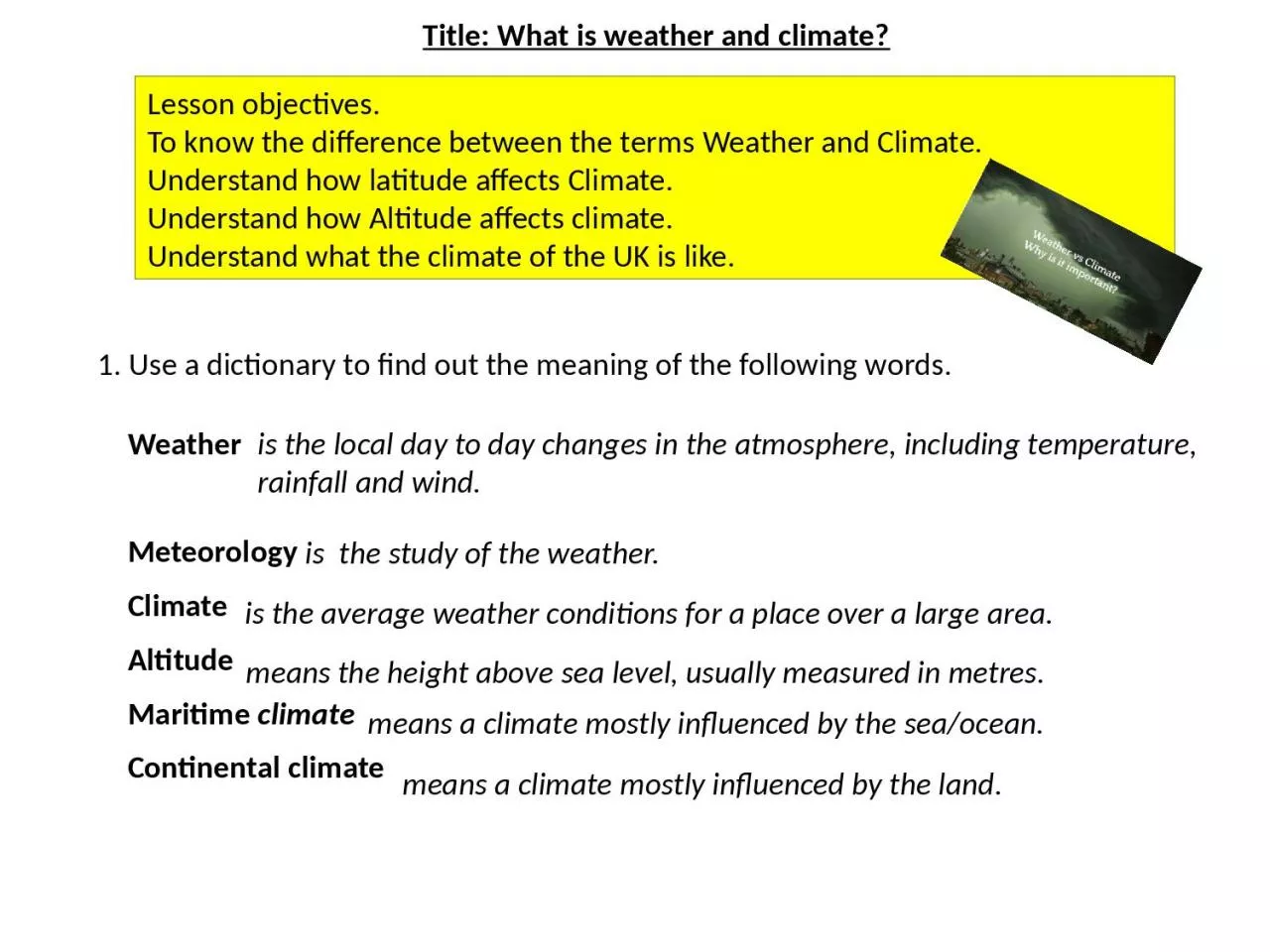
Altitude Maritime climate Continental climate Title What is weather and climate 1 Use a dictionary to find out the meaning of the following words Lesson objectives To know the difference between the terms Weather and Climate ID: 1023043

air climate summers weather climate air weather summers winters rainfall mild cold temperature prevailing equator warm wind west part

Share:

Link:

Embed:

Download Presentation from below link

Download Presentation The PPT/PDF document "Weather Meteorology Climate" is the property of its rightful owner. Permission is granted to download and print the materials on this web site for personal, non-commercial use only, and to display it on your personal computer provided you do not modify the materials and that you retain all copyright notices contained in the materials. By downloading content from our website, you accept the terms of this agreement.


Presentation Transcript

1. Weather Meteorology Climate AltitudeMaritime climateContinental climateTitle: What is weather and climate?1. Use a dictionary to find out the meaning of the following words.Lesson objectives.To know the difference between the terms Weather and Climate.Understand how latitude affects Climate.Understand how Altitude affects climate.Understand what the climate of the UK is like.is the local day to day changes in the atmosphere, including temperature, rainfall and wind.is the study of the weather.is the average weather conditions for a place over a large area. means the height above sea level, usually measured in metres.means a climate mostly influenced by the sea/ocean.means a climate mostly influenced by the land.

2. At the equator the sunlight is at its most intense because the Sun is mostly overhead. At the Poles sunlight strikes the Earth at an angle and is therefore spread out over a larger area, making the Sun`s radiation less intense. Why is it hotter at the Equator than at the Poles?2. Use the following diagram to explain why it is hotter at the equator than at the Poles.

3. Why does it get colder the higher up you go?Use the following diagram to describe the effect of altitude on temperature .At sea level you have about 14 pounds per square inch of air pressure pushing down on you. This high air pressure means the air is dense and can retain heat, so it is warm.High up in the atmosphere air pressure drops, the air becomes less dense and can not hold on to heat, so it is cold.1. Air molecules3. Use the following diagrams to explain why it is colder the higher up you go.4. At sea level, air pressure 1 kilogram per square cm.2. Earth's atmosphere is about 300 miles thick, but most of it is within10 miles the surface. Low air pressure.3. The air is thin so there are less modules in the air to retain heat.High air pressure.5. The air is dense so there are more modules in the air to retain heat.Gravity

4. What is Britain`s weather like?Mild summers and winters. Wet.Mild summers and cold winters. Dry.Warm summers and mild winters. Wet.Warm summers and cold winters. Dry.Prevailing wind

5. What can Climate graphs tell us?Fort William, Margate, What do the letters along the x-axis (the bottom of the graph) represent?What do you think the RED line means?What do you think the BLUE bars are showing?Where in the British Isles are Fort William and Margate?Looking at the information, which location is further North? How can you tell?

6. Label the following places on the UK map. Penzance Fort William Margate Aberdeen2. Label the Atlantic Ocean.3. Label the arrow `Prevailing wind`.4. Write the correct description next to each of the graphs Mild summers and winters. Wet.Mild summers and cold winters. Dry.Warm summers and mild winters. Wet.Warm summers and cold winters. Dry.Title: What is Britain`s weather like?5. Draw and complete this table.6. Explain why Aberdeen has lower temperatures than Margate. TemperatureJanuaryAugustAberdeenMargateTotal RainfallFort WilliamAberdeenDifferencemm7. Draw and complete these tables.8. Explain why the west of Britain has more rainfall than the east. Total RainfallPenzanceMargateDifferencemm

7.

8. What is Britain`s weather like?Mild summers and winters. Wet.Mild summers and cold winters. Dry.Warm summers and mild winters. Wet.Warm summers and cold winters. Dry.Prevailing windAtlantic OceanPenzanceMargateFort WilliamAberdeen

9. Why does the west of Britain get more rain than the east?Total RainfallPenzanceMargateDifferencemm1050540510Total RainfallFort WilliamAberdeenDifferencemm20206401380Prevailing windAtlantic OceanPrevailing wind from the south west brings moisture from the Atlantic Ocean. This air is forced to rise above the hills and mountains in the west of Britain, resulting in relief rainfall. As the air continues to travel eastwards it passes over lower land so it sinks back down, resulting in less rainfall .WETDRY

10. Why is Margate warmer than Aberdeen?Prevailing windAtlantic OceanTemperatureJanuaryAugustAberdeen315The curvature of the Earth spreads out the sunshine the Earth receives over a larger area in the north than in the south. Therefore, Aberdeen, which is located further north than Margate, receives less intense sunshine and has cooler temperatures.TemperatureJanuaryAugustMargate518

11. What are the three types of rainfall?RELIEF PRECIPITATION (rainfall)FRONTAL PRECIPITATION (rainfall)CONVECTIONAL PRECIPITATION (rainfall)Watch this YouTube video….What are the 3 types of rainfall?Describe how all three cause rain, use diagrams in your explanation?What do they all have in common, what do they make clouds do?Which type effects the British Isles the most?

12. Title: What is weather and climate?What does Weather mean?2. What does Climate mean?3. What happens to temperature the further from the equator you travel?4. What happens to temperature the higher up you go?5. Which part of the UK has the Warmest and wettest climate?6. Which part of the UK has the coolest and driest climate?7. Which part of the UK has the warmest and driest climate?How do the following three factors effect the UK`s climate? 8. Latitude 9. Prevailing wind 10. Relief (Shape of the land)

13. Recap: What is weather and climate?What does Weather mean?2. What does Climate mean?3. What happens to temperature the further from the equator you travel?4. What happens to temperature the higher up you go?5. Which part of the UK has the Warmest and wettest climate?6. Which part of the UK has the coolest and driest climate?7. Which part of the UK has the warmest and driest climate?How do the following three factors effect the UK`s climate? 8. Latitude 9. Prevailing wind 10. Relief (Shape of the land) The day to day changes in the atmosphere over a small areaThe average weather conditions over a long time and large area.Temperature decreases the further from the equator you travel.Temperature decreases the higher up in the atmosphere you go.The south westThe north eastThe south eastThe UK is about half way between the equator and the North Pole and it therefore has a moderate climate, not too hot or too cold.The south west prevailing wind brings moisture from the Atlantic Ocean. Although this brings us rain, it also warms the climate in the winter and cools the climate in the summer.The hills and mountains in the west of the UK force the air to rise, this results in more rainfall in the west of the UK than in the east.