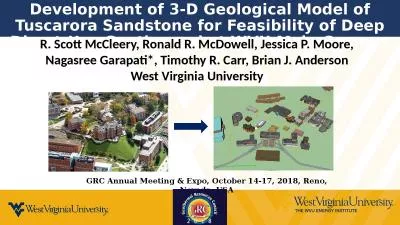
PPT-Progress towards the National Geological Model of Britain
Author : sherrill-nordquist | Published Date : 2017-09-02
Steve Mathers Holger Kessler amp Jon Ford GSA 3D Modelling Workshop Denver 26 October 2013 121 sections c 22000 line kms b uilt by 20 regional geologists supported
Presentation Embed Code
Download Presentation
Download Presentation The PPT/PDF document "Progress towards the National Geological..." is the property of its rightful owner. Permission is granted to download and print the materials on this website for personal, non-commercial use only, and to display it on your personal computer provided you do not modify the materials and that you retain all copyright notices contained in the materials. By downloading content from our website, you accept the terms of this agreement.
Progress towards the National Geological Model of Britain: Transcript
Steve Mathers Holger Kessler amp Jon Ford GSA 3D Modelling Workshop Denver 26 October 2013 121 sections c 22000 line kms b uilt by 20 regional geologists supported by a team of data . Lea Kiilaspea. Pille-Riin Jakobson. Katariina Lepik. Silvia Kutsar. Great Britain. Is an island in the Atlantic ocean. London. 60 million people. Unemployment. Total 7,1%. Youth 14,1%. Unemployment benefits. Interconnected geological heritage . Understanding, appreciation and enjoyment. socio-economic opportunities. Long term management of the features. AND. Operation Sea Lion. Alix Pletcher, Julia Hills, Maddy Calvert, Emilee Kaminski, Golda Ferraz. Thesis. The Battle of Britain, a completely air-based conflict, represented the first time the Nazi Empire didn’t easily succeed, damaging German self-esteem. This led Germany to turn away from Britain and target the Soviet Union.. Starter questions – . In 2016 the 5 GCSE A*-C measure will no longer be used – what will replace it- can you name the 2 measures.. Students results are calculated based on three “buckets” – do you know what these are?. 1780 - 1870. End of Napoleon. Following the turmoil of the French Revolution and the Napoleonic War, Europe entered yet another period of rapid and dramatic change.. While the victories over Napoleon at Waterloo ushered in an understanding between states each state suffered from continued oppressive rulers and ongoing social and political unrest. . PETROLEUM ENGINEERING. ÂNGELA PEREIRA (angela.pereira@tecnico.ulisboa.pt). Introduction. Frontier . basins and unexplored areas are challenging new venture projects due to the high risk and uncertainty related to scarcity of the data. Geological knowledge of the basin and seismic data are the main support in the first stages of an . GFSAD30m. Global Cropland Extent Products of . Australia Accuracies on irrigated croplands areas . . Pardhasaradhi Teluguntla, Prasad Thenkabail and Jun Xiong. 18. th. February, 2016. Drazhnja Ore Belt - Geological overview and 3D interpretation, Kosovo (SE Europe). Presenter:. MSc. . Bahri. . Hyseni. EurGeol. . Mentor Demi. Date 03.11.2018. ABSTRACT. The Drazhnja deposit is located in the Eastern Kosovo, 23 km northeast from Prishtina, in the external zone of the . Year 8 - Britain’ s place in the World. How did Britain help shape the world we live in and how did the world shape Britain?. Why did the British Build and Empire?. The Empire Builder. What was their role?. R. Scott . McCleery. , Ronald R. McDowell, Jessica P. Moore, Nagasree Garapati*, Timothy R. Carr, Brian J. Anderson. West Virginia University. GRC Annual Meeting & Expo, October 14-17, 2018, Reno, Nevada, USA. Geo 281: geology for engineers. Geology and Geophysics Department. King Saud University. ROCK . DEFORMATION (STRESS). Tectonic forces exert different types of stress on rocks in different geologic environments. . Time: Wed. 1 – 3 pm 3 UNITS. COURSE OUTLINE. MODULE 1. Map reading and interpretation of structural features and geological history in simple geological maps.. . MODULE . 2. Practical recording of geological features on base maps.. Thomas Oommen, . Associate Professor. Michigan Technological University, Michigan. Content. Introduction. Principles of Engineering Geological . M. apping (EGM). How to make engineering geological maps. Key Message #1. 26. Ch. 26 | Alaska. Marine Ecosystems. Alaska residents, communities, and their infrastructure continue to be affected by permafrost thaw, coastal and river erosion, increasing wildfire, and glacier melt. These changes are expected to continue into the future with increasing temperatures, which would directly impact how and where many Alaskans will live..
Download Document
Here is the link to download the presentation.
"Progress towards the National Geological Model of Britain"The content belongs to its owner. You may download and print it for personal use, without modification, and keep all copyright notices. By downloading, you agree to these terms.
Related Documents