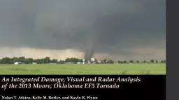
/
The Great Plains Storm Chase of May 2013 The Great Plains Storm Chase of May 2013

The Great Plains Storm Chase of May 2013 - PowerPoint Presentation

sherrill-nordquist
sherrill-nordquist . @sherrill-nordquist
Follow
431 views
Uploaded On 2017-01-19

The Great Plains Storm Chase of May 2013 - PPT Presentation

Featuring the EF5 Moore OK Tornado Trip planned Nov 2012 Duration May 16 May 24 2013 Participants Ohio State students amp alum Friends of the National Weather ServiceStorm Prediction Center ID: 511387

damage tornado chase storm tornado damage storm chase 2013 www service weather ef5 day national analysis chris moore oklahoma

Share:

Link:

Embed:

Download Presentation from below link

Download Presentation The PPT/PDF document "The Great Plains Storm Chase of May 2013" is the property of its rightful owner. Permission is granted to download and print the materials on this web site for personal, non-commercial use only, and to display it on your personal computer provided you do not modify the materials and that you retain all copyright notices contained in the materials. By downloading content from our website, you accept the terms of this agreement.


Presentation Transcript

Slide1

The Great Plains Storm Chase of May 2013Featuring the EF-5 Moore, OK TornadoSlide2

Trip planned Nov. 2012DurationMay 16 – May 24, 2013ParticipantsOhio State students & alumFriends of the National Weather Service/Storm Prediction CenterSenior Trip!Nighttime Storm in Norman, OK (May 21st) Jared Allen, National Weather ServiceLET’S GO CHASE SOME STORMS!!!Slide3
Slide4

Chase Day 1: May 18th, 2013Slide5

CLEAR SKIES – PERFECTStrong surface heatingStorms firing up ahead of drylineSlide6

Typical Storm MotionVantage PointSupercell

Structure and Ideal Vantage PointSlide7

GustnadoSlide8
Slide9

Chase Day 2: May 19th, 2013Slide10

WHEREISTHE TORNADO?“Rope out” stage Tornado is dissipatingSlide11

Modeling Tornado Dynamics“Genesis and Maintenance of a long-track EF-5 Tornado”Models an EF-5 tornado that occurred outside of Oklahoma City on May 24, 2011ModelersLeigh Orf, Central Michigan UniversityRoberth Wilhelmson, NCSA/UIUCLouis Wicker, NSSLBruce Lee, WindLogicsCatherine Finley, WindLogicsCloud Model 1 (CM1)3-D numerical simulationDeep precipitating convectionhttp://www.srh.noaa.gov/oun/?n=events-20110524Slide12

Touchdown SimulationSlide13

A Look InsideSlide14

Streamline AnalysisSlide15

Streamline AnalysisSlide16

Chase Day 3: May 20th, 2013The Moore, Oklahoma TornadoSlide17

May 20th, 2013 (15Z)Slide18
Slide19
Slide20
Slide21
Slide22
Slide23

Rapid IntensificationSlide24

Base Reflectivity Storm Relative MotionRadar SiteSlide25
Slide26
Slide27

EF Rating3 Second Wind Gust (mph)065 - 85186 - 110

2

111 - 135

3

136 - 165

4

166 - 200

5

>200

Damage path 14.5 miles; max width > 1 mile

EF0 and EF1 damage in northern Newcastle at 2:56 PM CDT

EF2, EF3 and EF4 damage observed 4 minutes later.

EF4 damage continues through Briarwood and Plaza Towers elementary schools.

Few locations experience EF5 damage.

24 fatalities

2:56 PM

3:00 PM

3:16 PM

3:36 PM

3:29 PMSlide28

Chris BirchfieldNational Weather ServiceSlide29

Chris BirchfieldNational Weather ServiceSlide30
Slide31

ReflectionsSlide32

ReferencesNolan T. Atkins, Kelly M. Butler, Kayla R. Flynn, and Roger M. Wakimoto, 2014: An Integrated Damage, Visual, and Radar Analysis of the 2013 Moore, Oklahoma, EF5 Tornado. Bull. Amer. Meteor. Soc., 95, 1549–1561.Storm Prediction Center Product & Report Archives: http://www.spc.noaa.gov/archive/Tornado Simulations: Leigh Orf, Central Michigan University, Mount Pleasant, MI; and R. B. Wilhelmson

, L. J. Wicker, B. D. Lee, and C. A.

Finley

.

“Genesis

and maintenance of a long-track EF5 tornado embedded within a simulated

supercell”.

Special thanks to Brian Shell, Chris

Birchfield

, and Jared Allen for some of the pictures!

Other images and radar animation:

www.atmos.albany.edu

,

https://

www.youtube.com/watch?v=ronIr-S3FJ0