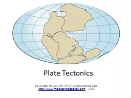
Liz LaRosa for use with my 5 th Grade Science Class httpwwwmiddleschoolsciencecom 2009 Earths Layers The Earths rocky outer crust solidified billions of years ago soon after the Earth formed ID: 141561
Download Presentation The PPT/PDF document "Plate Tectonics" is the property of its rightful owner. Permission is granted to download and print the materials on this web site for personal, non-commercial use only, and to display it on your personal computer provided you do not modify the materials and that you retain all copyright notices contained in the materials. By downloading content from our website, you accept the terms of this agreement.
Slide1
Plate Tectonics
Liz LaRosa for use with my 5th Grade Science Class http://www.middleschoolscience.com 2009 Slide2
Earth’s Layers
The Earth's rocky outer crust solidified billions of years ago, soon after the Earth formed.
This crust is not a solid shell; it is broken up into huge, thick plates that drift atop the soft, underlying mantle.Slide3
The Crust
Outermost layer5 – 100 km thickMade of Oxygen, Silicon, AluminumSlide4
The Mantle
Layer of Earth between the crust and the coreContains most of the Earth’s massHas more magnesium and less aluminum and silicon than the crust
Is denser than the crustSlide5
The Core
Below the mantle and to the center of the EarthBelieved to be mostly Iron, smaller amounts of Nickel, almost no Oxygen, Silicon, Aluminum, or MagnesiumSlide6
Tectonic PlatesSlide7
Plate Tectonics
Greek – “tektonikos” of a builderPieces of the lithosphere(Earth’s crust) that move aroundEach plate has a nameFit together like jigsaw puzzlesFloat on top of mantle similar to ice cubes in a bowl of waterSlide8
Continental Drift
http://members.enchantedlearning.com/subjects/astronomy/planets/earth/Continents.shtml
Alfred Wegener
1900’s theory that
Continents
were once a single land mass that drifted apart.
Fossils of the same plants and animals are found on different continents
Called this supercontinent
Pangaea
, Greek for “all Earth”
245 Million years ago
Split again –
Laurasia
&
Gondwana
180 million years agoSlide9
Evidence of PangeaSlide10
Sea Floor SpreadingSlide11
Sea Floor Spreading
Mid Ocean Ridges – underwater mountain chains that run through the Earth’s BasinsMagma rises to the surface and solidifies and new crust forms
Older Crust is pushed
farther away from the ridgeSlide12
How Plates Move
http://pubs.usgs.gov/gip/dynamic/unanswered.html
Slide13
Different Types of Boundaries
http://pubs.usgs.gov/gip/dynamic/understanding.html Slide14
Divergent Boundary –
Arabian and African Plates
Arabian Plate
African Plate
Red SeaSlide15
Divergent Boundary –
Iceland
http://pubs.usgs.gov/gip/dynamic/understanding.html
Slide16
Divergent Boundary - Oceanic
http://www.geology.com Slide17
Divergent Boundary - Continental
http://www.geology.com Slide18
Convergent Boundary – Indian and Eurasian
PlatesThe red marker identifies the Himalaya Mountains
Indian Plate
Eurasian PlateSlide19
Convergent Boundary – Oceanic & Continental
http://pubs.usgs.gov/gip/dynamic/understanding.html
&
http://www.geology.com
Slide20
Convergent Boundary – Oceanic & Oceanic
http://pubs.usgs.gov/gip/dynamic/understanding.html
&
http://www.geology.com
Note – plates are reversedSlide21
Convergent Boundaries - Continental
http://pubs.usgs.gov/gip/dynamic/understanding.html &
http://www.geology.com
Slide22
Transform Boundary – San Andreas Fault
www.geology.com
Slide23
Review
Name the 3 main layers of the EarthWhat is a tectonic plate?What was Pangea?What is Sea-Floor spreading?Name the three different types of plate boundaries and one location on Earth for each one