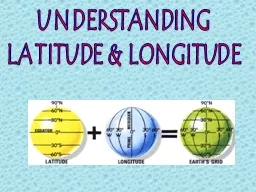
PPT-Map Skills Time Zones Longitude Lines run east and west.

Author : trish-goza | Published Date : 2019-02-25

Time Zones run in the same direction as longitude lines Each color is a different Time Zone Vocabulary A time zone is a region of the earth that has the same time

Presentation Embed Code

Download Presentation

Download Presentation The PPT/PDF document "Map Skills Time Zones Longitude Lines ru..." is the property of its rightful owner. Permission is granted to download and print the materials on this website for personal, non-commercial use only, and to display it on your personal computer provided you do not modify the materials and that you retain all copyright notices contained in the materials. By downloading content from our website, you accept the terms of this agreement.

Map Skills Time Zones Longitude Lines run east and west.: Transcript


Time Zones run in the same direction as longitude lines Each color is a different Time Zone Vocabulary A time zone is a region of the earth that has the same time There are 24 time zones. . In relation to:. Neighbouring islands. Bodies of water. Lines of latitude. Lines of longitude. Saint Lucia is located in the eastern Caribbean Sea but also near the Atlantic Ocean. . Saint Lucia is part of the Lesser Antilles and the Windward Islands. Saint Lucia is also located north east of Saint Vincent, north west of Barbados and south of Martinique. . What . country lies at 0°, 20° E. ? . (Pg. RA22). a. Sudan. b. . Gabon. c. . Uganda. d. . Democratic . Republic of the Congo. . Last Night’s Homework. Please take out your homework from last night.. 2. Grid System. Lines of latitude and longitude cover the entire Earth, allowing us to find any location.. The . cardinal directions. are North, South, East and West.. Lines of Latitude run East to West. Time Zones. Longitude Lines run east and west.. Time Zones run in the same direction as longitude lines.. Each color is a different Time Zone. Vocabulary. A. . time zone . is a region of the earth that has the same time. There are 24 time zones.. Hemispheres. A place can be either in the NORTHERN or SOUTHERN hemisphere. That means it is in one of the halves above or below the imaginary east-west line known as the EQUATOR.. A place can also be in either the WESTERN or EASTERN hemisphere. That means it is in one of the halves on either side of the imaginary north-south line known as the PRIME MERIDIAN.. Do Now. : Why do you think we call the equator the equator?. HW: Latitude/Longitude practice . ws. . . 4 Hemispheres. The equator splits apart the Northern and Southern Hemisphere. The Prime Meridian and International Date Line split the Eastern and Western. 7.3.spi.17. read and interpret a time zone map.. (Bloom’s Taxonomy level 6). Estimated Lesson Length: 1 day. Activating Strategy. Students will discuss with a partner why we see the Olympics at a different time then they do in London?. Longitude’s Role. Longitude plays the most important role in telling time. There are 360◦ of longitude (180◦ West and 180◦ East of Prime Meridian). Longitude lines are spaced 15◦ apart in both directions from the. Royal Observatory . Greenwich Mean Time (GMT). This is the universal time used for many things:. Air craft. Weather maps. Email. NASA Space Shuttles. This is the time at the prime meridian. Not affected by daylight savings . A . time zone. is a region that has a standard time throughout it. There are 24 times zones throughout the world. Why do We Need Standard Time?. Before the late 1800s, towns and cities would set their own times based on the sun. Ch. 4.2. Effect of Earth’s rotation. Created based on the rate at which the sun appears to move across the sky. Sun . rises . in the . east. & . sets. in the . west. Earth takes . 24 hours . to rotate on its axis . How do you know whether it is or isn’t?. Who made the first map? Or globe?. What do maps show us? . Earth’s surface, political borders, population, geography, . ect. . . Geography. Latitude and Longitude. November 03 /2018 . Background. Oromo and Benishangul Gumuz ethnics have living together for many centuries sharing same value, culture, languages and other social practices in common. However, following the recent border conflict about . November 03 /2018 . Background. Oromo and Benishangul Gumuz ethnics have living together for many centuries sharing same value, culture, languages and other social practices in common. However, following the recent border conflict about .

Download Document

Here is the link to download the presentation.
"Map Skills Time Zones Longitude Lines run east and west."The content belongs to its owner. You may download and print it for personal use, without modification, and keep all copyright notices. By downloading, you agree to these terms.

Related Documents