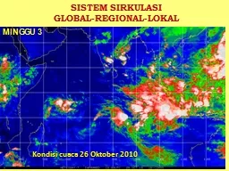
Kondisi cuaca 26 Oktober 2010 MINGGU 3 SIRKULASI UDARA GLOBAL Sel Hardley Gerakan massa udara ini akibat perbedaan insolasi yang diterima muka bumi secara ID: 713301
Download Presentation The PPT/PDF document "SISTEM SIRKULASI GLOBAL-REGIONAL-LOKAL" is the property of its rightful owner. Permission is granted to download and print the materials on this web site for personal, non-commercial use only, and to display it on your personal computer provided you do not modify the materials and that you retain all copyright notices contained in the materials. By downloading content from our website, you accept the terms of this agreement.
Slide1
SISTEM SIRKULASI
GLOBAL-REGIONAL-LOKAL
Kondisi cuaca 26 Oktober 2010
MINGGU
3Slide2
SIRKULASI UDARA GLOBAL
Sel
HardleyGerakan
massa
udara
ini
akibat perbedaan insolasi yang diterima muka bumi secara spasial dan temporal.
Di
sekitar
Equator
terjadi
pengangkatan
massa
udara
terjadi
akumulasi
uap
air (
awan
) Slide3
Model
Sirkulasi Udara Global (NASA) Slide4
Polar Front Jet Stream (PFJS):
This is found between 400 and 600 in both hemispheres and is the division between the Polar and Ferrel cells. The jet stream moves about and brings different weather depending on where it is coming from.
Sub Tropical Jet Stream (STJS): This is found around 250 to 300 and is the boundary between the Ferrel and the Hadley cell. It moves less than the polar jet stream and has lower wind velocities, but does follow a west-east path. Easterly Equatorial Jet Stream (EEJS): This is more seasonal and is associated with the summer monsoon in India.Slide5
Schematic figure of seasonal variations over Indonesia. The Hadley circulation shifts southward in the northern winter and northward in the northern summer. Along the boundary of the two cells (that is, ITCZ), the Walker circulation which has westerly in the lower troposphere and easterly in the upper troposphere is superimposed. (Okamoto et.al., 2003)Slide6
This results in the anomalous Walker Circulation (WC) over the tropical IO, as seen in the convergence (divergence) field of wind at 200
hPa
over the eastern (western) tropical IO (a). This anomalous WC associated with the easterly wind anomaly in the lower troposphere leads to decreased (increased) precipitation over the eastern (western) tropical IO (b).Slide7
Geographical position of Indonesia between Hadley circulation (North-South) that crosscut by Walker Circulation (West-East) is
posible way to endure water vapour around IndonesiaInterchange of Indonesian ocean water to the Indian ocean on west or pacific ocean on east transfered warm around Indonesian regional scale of SST
HINDIA
PASIFICSlide8
Please look at the moving of center convection over Indonesia both in 850 & 200 mbSlide9
(http://www.cpc.ncep.noaa.gov/products/Global_Monsoons/Asian_Monsoons/wind_polrc_anim_asia.gif) Slide10
Atlantic hurricane tracks during (a) the AMO cold phase and (b) the AMO warm phase.
The AMO has also been associated with multidecadal Atlantic hurricane activity More tropical storms become major hurricanes during the AMO warm phase than during the cool phase.
When the tropical north Atlantic is anomalously warm (positive AMO), less rain falls over most of the US and northeastern South America, and more rain falls in southern Alaska, northern Europe, west Africa, and the southeastern US163. Persistent drought across the Midwest US, such as the 1930s Dust Bowl years, was associated with positive AMO.Slide11
ANGIN MONSOON
Monsoon
Musim Dingin / Muson Barat
Monsoon
Musim
Panas
/
Muson Timur
Terjadi
akibat
revolusi
bumi
(
gerak
semu
matahari
).
Monsoon
Musim
Dingin
(MMD)
terjadi
ketika
matahari berada
di sebelah selatan equator, sebalik nya Monsoon Musim Panas (MMP) ketika matahari di sebelah utara equator.Angin MMD bersifat lembab (uap air banyak) di Indonesia (barat) curah hujan besar (musim hujan).Angin MMP bersifat kering (uap air sedikit) di Indonesia (barat) curah hujan kecil (musim kemarau)
Aktivitas ekonomi penduduk (pertanian & perikanan laut) sangat dipengaruhi pola sirkulasi angin monsoon ini.Slide12
The surface of the Earth exerts a frictional drag on the air blowing just above it. This friction can act to change the wind's direction and slow it down -- keeping it from blowing as fast as the wind aloft. Actually, the difference in terrain conditions directly affects how much friction is exerted. For example, a calm ocean surface is pretty smooth, so the wind blowing over it does not move up, down, and around any features. By contrast, hills and forests force the wind to slow down and/or change direction much more. Slide13
Suhu muka laut adalah
salah satu
faktor pengendali utama dinamika iklim di Indonesia.
T
ahun
2010 suhu muka laut Indonesia bertahan cukup
tinggi
,
rata rata diatas 29 0C.SPL
tinggi
diatas
rata rata normalnya
maka
terjadi penguapan
tinggi
,
ditambah
masukan
uap
air
akibat
sirkulasi
Walker &
sirkulasi
Hadley
menyebabkan curah
hujan yang tinggi.
Kondisi tahun 2016 serupa dengan tahun 2010SUHU MUKA LAUT RATA-RATA PERAIRAN INDONESIA TAHUN 2010Slide14
Indonesia (90BT – 140BT) mengalami fenomena osilasi intraseasonal yang dikenal sebagai osilasi Madden Julian.
Dalam osilasi ini terjadi perioda basah (
biru) dan kering (kuning) pada skala 30-90 harian.Di tahun 2010 osilasi ini memendek seiring dengan kemarau basah menjadi sekitar 30 harian. Sehingga resiko basah meningkat dan jeda kering berkurang
Indonesia
DAMPAK
OSILASI MADDEN JULIAN DI WILAYAH TROPISSlide15
Wind/Temp 1000 hPa
WindTemp InformationSlide16
ANGIN DAN TEMPERATUR - LAPISAN 180 mbSlide17
ARAH
dan KECEPATAN ANGIN (STREAM LINE) 17 NOVEMBER
2009 PK. 07.00 WIBSlide18
Surface Zonal Wind
DEC 1979-2006
DEC 2015-2034
DEC 2075-2096
AUG 1979-2006
AUG 2015-2034
AUG 2075-2096Slide19
The Change of Zonal Wind on December and August
Increasing almost all sea over Indonesia
Surface Zonal Wind DEC Near - Present
Surface Zonal Wind DEC Future - Present
Surface Zonal Wind AUG Near - Present
Surface Zonal Wind AUG Future - PresentSlide20
ANGIN LOKAL
Angin Darat
Angin Laut
Terjadi
akibat
beda
pemanasan
/
pendinginan
udara
(air
pressu
re) pd
siang
&
malam
hari
.
Pengaruh
angin
laut
ke
darat sejauh 10 – 30 Km (tergantung morfologi/ bentuk medan).Udara di daerah perali-han jadi kurang stabil, pada saat-saat tertentu banyak penduduk (balita) terserang flu, batuk, dll. Angin Lokal selalu berubah arah antara siang dan malam hari.Dimanfaatkan oleh nelayan dengan perahu layar untuk melaut pada
malam hari.Slide21
PROSES GENESIS ANGIN DARAT / LAUT
Angin
Darat
Angin
Laut
Massa
udara
di
atas
laut
lebih
lambat
mengalami
pemanasan
dibanding
udara
di
atas
daratan, sehingga
tekanan udara di atas laut lebih tinggi tekanannya.Massa udara di atas daratan lebih cepat mengalami pendinginan dibanding udara di atas laut, sehingga udara di atas daratan lebih tinggi tekanannya.Slide22
SEKIAN DULU YAH……