
APPLIED GEOMORPHOLOGY SLOPE DEVELOPMENT THEORIES

Description: APPLIED GEOMORPHOLOGY SLOPE DEVELOPMENT THEORIES W.M. DAVIS Dr. B.ANUSUYA, Assistant Professor Head, Department of Geography, Government College for Women (A), Kumbakonam. GOVERNMENT COLLEGE FOR WOMEN (AUTONOMOUS) KUMBAKONAM DEPARTMENT OF
Related Topics
Download Presentation
"APPLIED GEOMORPHOLOGY SLOPE DEVELOPMENT THEORIES" is the property of its rightful owner. Permission is granted to download and print the materials on this website for personal, non-commercial use only, and to display it on your personal computer provided you do not modify the materials and that you retain all copyright notices contained in the materials. By downloading content from our website, you accept the terms of this agreement.
Presentation Transcript
slide1. APPLIED GEOMORPHOLOGY
SLOPE DEVELOPMENT THEORIES
W.M. DAVIS Dr. B.ANUSUYA,
Assistant Professor & Head,
Department of Geography,
Government College for Women (A),
Kumbakonam. GOVERNMENT COLLEGE FOR WOMEN (AUTONOMOUS) KUMBAKONAM
DEPARTMENT OF GEOGRAPHY I – M.Sc - GEOGRAPHY<br>
slide2. UNIT: IV APPLIED GEOMORPHOLOGY - P18GC101 SLOPE DEVELOPMENT THEORIES W.M.DAVIS How are slopes formed?
Definition of Slope Development:
Slopes can be genetically categorizes into primary slopes, formed by processes that tend to promote relief, and secondary slopes, formed by processes tending to decrease relief. Secondary slopes evolve from the erosion and modification of primary slopes.<br>
slide3. What are slope processes?
The slope processes include weathering, erosion, transport and deposition of the material. Weathering is the process by which material is prepared for transport. Weathering is the response of the materials within the lithosphere to conditions at or near its contact with the atmosphere, hydrosphere and biosphere.
Erosional processes along coastlines include: (1) The direct effects of hydraulic action, wedging, and cavitation by waves; (2) abrasion (corrasion), using sand, gravel, and larger rock fragments as tools; (3) attrition of the rock particles themselves during this abrasive action; (4) salt weathering or fretting.<br>
slide4. Definition of Slopes
Although enormous literature has been built on this subject by geomorphologists, engineers, geologists, soil scientists, etc., probably there is no definition of the term ‘slope’. Most land and submarine surfaces have some slope or inclination however small. What are dead level plains also have some slope making drainage of rainfall or precipitation as sheet or channelized flow possible.
However, the study of slope by geomorphologists, etc, generally considers slopes of perceptible inclination such as we see on the mountain ranges, ridges, scarps, edges of plateaus, on the flanks of monadnocks, inselbergs and on the sides of narrow deep-cut valleys.<br>
slide5. But it may be mentioned without ambiguity that although most surfaces including practically level cultivated fields have slopes, it is the relatively spectacular slopes that form the subject of slope studies. Practically flat alluvial plains, coastal plains, or very even plateaus fall outside the purview of slope studies.
Factors that Influence the Slope Development
The factors influencing slope development are numerous. Lithology, tectonic characteristics and age of rocks form one set of important factors. Climate and its change constitute another. Tectonic movements and eustatic change of sea level are highly important. Vegetation by providing a protective cover or influencing hydrology or affecting transport of weathered material or otherwise must form another important factor.<br>
slide6. Thus, Nature is as variable in the details of slopes as in several phenomena. Just as each of some 6,000,000,000 human beings has distinct stature, face, voice, build, attitude, temperament, outlook, character, etc. so is the case with each slope, in whatever site, situation and region, it may be. This makes generalization and quantification about slopes all the more baffling.
This baffling variety must be borne in mind despite all the meticulous quantitative studies and quantification pertaining to slopes.
According to W.M. Davis “landscape is a function of structure, process and stage”. Slope may be described as function of structure, process, stage and tectonics. The structure may be included under the original slope form. The effects of climate, hydrology, glaciation, vegetation, soils, biological factors and probably even tectonics may be included under process. The stage or the time factor in monocyclic or multicyclic slopes is indeed extremely important.<br>
slide7. The original nature of the surface, e.g., the angle of inclination, its form in respect of concavity, convexity, uniformity, marked knicks or breaks and dislocated surfaces like those along faults will affect the present form of the slopes.
Polycyclic nature of slopes, wherever this is the case, it is definitely an important factor to bear in mind in the correct interpretation of slopes. Variety of factors is indeed bewilderingly large and even in the same environment and microregion there may be baffling variations. “Within a single climatic environment some slopes may recline whereas others retreat parallel”<br>
slide8. Although submarine slopes have been investigated by oceanographic surveys and researches, they form a subject of the future so far as their detailed analysis is concerned. Buried under the load of oceanic waters and isolated from the atmosphere their development is mostly different from the slopes on land surfaces.
Thus, in the study of slopes we are concerned with the slopes on land areas. No limit to the degree of slopes appears to have been set by the students of the subject, but mostly it is the slopes which we have summarily mentioned above and which have their application in agriculture, soil characteristics, hydrology, engineering activities, etc.<br>
slide9. Slope Formation
The all landforms slopes are clearly the most common and often the most overlooked. Understanding slope processes is of particular interest to land use planners, and because slopes often reflect changes in lithology they are of particular interest to bedrock mappers.
Slopes can be genetically categorizes into primary slopes, formed by processes that tend to promote relief, and secondary slopes, formed by processes tending to decrease relief. Secondary slopes evolve from the erosion and modification of primary slopes. The distinction is not always clear because primary and secondary processes do not operate independently. However, its important to understand to what degree a slope is the result of primary and secondary processes. Many slopes are paleoslopes formed under a different climatic regime.<br>
slide10. What factors influence slope development?
The factors influencing slope development are numerous. Lithology, tectonic characteristics and age of rocks form one set of important factors. Climate and its change constitute another. Tectonic movements and eustatic change of sea level are highly important. Who developed the theory of landform development?
The most popular theory of landform development was given by American geomorphologist William Morris Davis. His concept of geographical cycle (or commonly known as cycle of erosion) provided a genetic classification and systematic description of landforms.<br>
slide11. This is especially true in New England where slopes occupy the flanks of relict glacial features, such as drumlins, moraines, glacial troughs, and meltwater valleys. A slope's shape is governed by its internal structure and external processes, such as slope wash, creep and other mechanisms of sediment transport. Material deposited while in transit down the slope is termed colluvium--an unsorted mixture of rock and sediment derived from the slope face.
Origins of primary slopes
Tectonic (fault scarps)
Depositional (volcanoes, glacial moraines, drumlins(?), dunes, alluvial fans, delta foreset, etc.)
Erosional (glacial and riverine valleys, etc.)
Human activity (blasted rock slopes, hydraulic mining, tailings piles, etc)<br>
slide12. Processes acting on slopes
Mass Wasting , creep, flow, fall, etc
Action of water
Raindrop impact (aids in the suspension of sediment)
Slope wash (Horton overland flow, sheetflow)
Channelized flow (rills)
Subsurface flow (elluviation and solute transport, sapping, and throughflow.
How process affects slope morphology
Mass movement and morphology
Creep leads to the development of convex upward slope segments
Solifluction, slumps, and flows commonly result in concave upward profiles at their heads and convex toes of colluvium<br>
slide13. Solifluction, slumps, and flows commonly result in concave upward profiles at their heads and convex toes of colluvium
Rock fall forms a talus (scree slope)beneath a free face (cliff)
Slope of talus is governed by:
Angularity of sediment
Rate of rock fall vs. rate of weathering and erosion of talus
Pediment surfaces that lack significant debris beneath the free face develops because talus is weathered and removed faster than it is produced.<br>
slide14. Effects of Water
Surface flow (Horton overland flow, or slopewash, and channel flow):
Aids the development of concave upward profiles in valleys and
Convex upward profiles along divides
Subsurface flow (downward percolation, throughflow and groundwater flow)
Aids in elluviation (minor?mechanism of slope decline)
Aids in the formation of earthflows and solifluction
May lead to surface channel formation by piping (sapping).<br>
slide15. Other factors influencing Slope Morphology
1. Geology: Slope composition and structure controls the detachability of slope material by a particular process
Rock slopes: Slope is controlled by rock strength and structure.
Rock strength: high strength promotes the development of a free face low strength promotes flatter slopes (fig. 1)
Structure: orientation, type and abundance of planes of weakness (e.g. bedding planes & joints)
Fall faces typically occur where
There is an active geologic agent oversteepening the slope<br>
slide16. Previously oversteepened slope has not yet been deeply weathered or consumed by colluvium
Change in base level exhumes buried topography
Soil slopes: Shape controlled more by processes
Erosion by water is influenced by permeability and erodibility of slope materials and vegetative cover
Sharp divides typically develop on poorly vegetated, impermeable and easily eroded slopes (fig. 2)
Mass wasting is influenced by sediment characteristics (cohesiveness, grain size, sorting and angularity), degree of consolidation, and structure.<br>
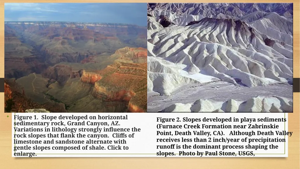
slide17. Figure 1. Slope developed on horizontal sedimentary rock, Grand Canyon, AZ. Variations in lithology strongly influence the rock slopes that flank the canyon. Cliffs of limestone and sandstone alternate with gentle slopes composed of shale. Click to enlarge. Figure 2. Slopes developed in playa sediments (Furnace Creek Formation near Zabrinskie Point, Death Valley, CA). Although Death Valley receives less than 2 inch/year of precipitation runoff is the dominant process shaping the slopes. Photo by Paul Stone, USGS,<br>
slide18. 2. Climate
controls intensity of chemical vs. mechanical weathering
controls vegetation and water content
In arid landscapes lacking vegetation, such as those shown in figures 1 and 2, fluvial erosion is quite effective.
Generalizations regarding the effects of climate:
Humid
Slope form is controlled by processes acting on regolith: slopes tend to be transport limited
Arid/semiarid
Lack of vegetation increases the efficiency of water and wind
slope form is controlled by bedrock strength and characteristics: slopes tend to be weathering limited<br>
slide19. 3. Local activity: Rates of mass-wasting are promoted by:
Proximity to stream, shoreline, etc.
Ativity of man
Rate of uplift and incision; relief
Terminology used to describe slopes
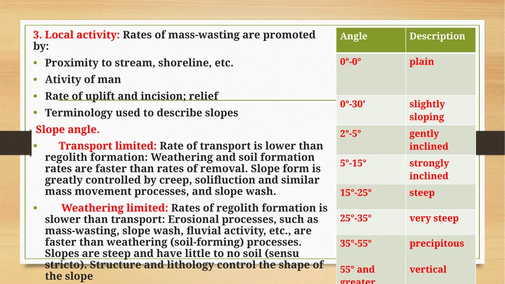
Slope angle.
Transport limited: Rate of transport is lower than regolith formation: Weathering and soil formation rates are faster than rates of removal. Slope form is greatly controlled by creep, solifluction and similar mass movement processes, and slope wash.
Weathering limited: Rates of regolith formation is slower than transport: Erosional processes, such as mass-wasting, slope wash, fluvial activity, etc., are faster than weathering (soil-forming) processes. Slopes are steep and have little to no soil (sensu stricto). Structure and lithology control the shape of the slope<br>
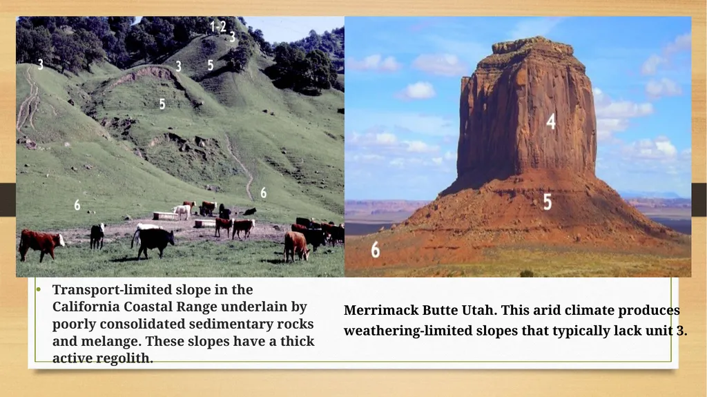
slide20. Transport-limited slope in the California Coastal Range underlain by poorly consolidated sedimentary rocks and melange. These slopes have a thick active regolith. Merrimack Butte Utah. This arid climate produces weathering-limited slopes that typically lack unit 3.<br>
slide21. Slope Development Theories - W.M.DAVIS
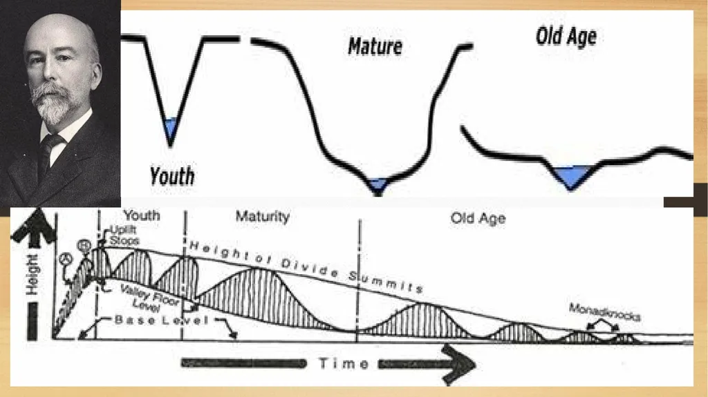
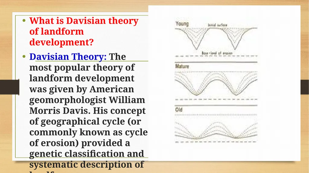
The theory was originated with the cycle of erosion of W.M Davis. Slope decline theory explains the evolution of the slope and subsequent transformation from steeper slope to gentle one. In accordance to the cycle of erosion Slope evolution/ Slope development occurs through 4 phases such as (i) Rejuvenation (ii) Young (iii) Mature and (iv) Old.
Slope decline (W.M. Davis - New England)
Upper slope weathers and erodes at at faster rate so there is progressive decline of slope angle occurs. Hillslopes have a thick mantle of regolith<br>
slide23. Davisian Theory
The most popular theory of landform development was given by American geomorphologist William Morris Davis. His concept of geographical cycle (or commonly known as cycle of erosion) provided a genetic classification and systematic description of landforms.
According to Davis, geographical cycle is a period of time during which an uplifted landmass undergoes its transformation by the process of land sculpture ending into low featureless plain or peneplain (which Davis called peneplane), Davis’s theory was the outcome of a set of theories and models presented by him during the 1880s and 1890s.<br>
slide25. He propounded the model of ‘complete cycle of river life’ in his essay on The Rivers and Valleys of Pennsylvania (1889), and that of ‘geographical cycle’ (1899) and ‘slope evolution’. He, under the concept of ‘complete cycle of river life’, postulated the cycle concept of progressive development of erosional stream valleys, and through the ‘geographical cycle’ described the sequential development of landforms through time.
However, Prof. Savindra Singh says that the general theory of landform development of Davis is not the ‘geographical cycle’ as many of the geomorphologists believe. Davis’s theory may be expressed as: “There are sequential changes in landforms through time (passing through youth, mature and old stages) and these sequential changes are directed towards well defined end product development of peneplain”.<br>
slide26. What is Davisian theory of landform development?
Davisian Theory: The most popular theory of landform development was given by American geomorphologist William Morris Davis. His concept of geographical cycle (or commonly known as cycle of erosion) provided a genetic classification and systematic description of landforms.<br>
slide27. Thank you<br>
Assistant Professor & Head,
Department of Geography,
Government College for Women (A),
Kumbakonam. GOVERNMENT COLLEGE FOR WOMEN (AUTONOMOUS) KUMBAKONAM
DEPARTMENT OF GEOGRAPHY I – M.Sc - GEOGRAPHY<br>
slide2. UNIT: IV APPLIED GEOMORPHOLOGY - P18GC101 SLOPE DEVELOPMENT THEORIES W.M.DAVIS How are slopes formed?
Definition of Slope Development:
Slopes can be genetically categorizes into primary slopes, formed by processes that tend to promote relief, and secondary slopes, formed by processes tending to decrease relief. Secondary slopes evolve from the erosion and modification of primary slopes.<br>
slide3. What are slope processes?
The slope processes include weathering, erosion, transport and deposition of the material. Weathering is the process by which material is prepared for transport. Weathering is the response of the materials within the lithosphere to conditions at or near its contact with the atmosphere, hydrosphere and biosphere.
Erosional processes along coastlines include: (1) The direct effects of hydraulic action, wedging, and cavitation by waves; (2) abrasion (corrasion), using sand, gravel, and larger rock fragments as tools; (3) attrition of the rock particles themselves during this abrasive action; (4) salt weathering or fretting.<br>
slide4. Definition of Slopes
Although enormous literature has been built on this subject by geomorphologists, engineers, geologists, soil scientists, etc., probably there is no definition of the term ‘slope’. Most land and submarine surfaces have some slope or inclination however small. What are dead level plains also have some slope making drainage of rainfall or precipitation as sheet or channelized flow possible.
However, the study of slope by geomorphologists, etc, generally considers slopes of perceptible inclination such as we see on the mountain ranges, ridges, scarps, edges of plateaus, on the flanks of monadnocks, inselbergs and on the sides of narrow deep-cut valleys.<br>
slide5. But it may be mentioned without ambiguity that although most surfaces including practically level cultivated fields have slopes, it is the relatively spectacular slopes that form the subject of slope studies. Practically flat alluvial plains, coastal plains, or very even plateaus fall outside the purview of slope studies.
Factors that Influence the Slope Development
The factors influencing slope development are numerous. Lithology, tectonic characteristics and age of rocks form one set of important factors. Climate and its change constitute another. Tectonic movements and eustatic change of sea level are highly important. Vegetation by providing a protective cover or influencing hydrology or affecting transport of weathered material or otherwise must form another important factor.<br>
slide6. Thus, Nature is as variable in the details of slopes as in several phenomena. Just as each of some 6,000,000,000 human beings has distinct stature, face, voice, build, attitude, temperament, outlook, character, etc. so is the case with each slope, in whatever site, situation and region, it may be. This makes generalization and quantification about slopes all the more baffling.
This baffling variety must be borne in mind despite all the meticulous quantitative studies and quantification pertaining to slopes.
According to W.M. Davis “landscape is a function of structure, process and stage”. Slope may be described as function of structure, process, stage and tectonics. The structure may be included under the original slope form. The effects of climate, hydrology, glaciation, vegetation, soils, biological factors and probably even tectonics may be included under process. The stage or the time factor in monocyclic or multicyclic slopes is indeed extremely important.<br>
slide7. The original nature of the surface, e.g., the angle of inclination, its form in respect of concavity, convexity, uniformity, marked knicks or breaks and dislocated surfaces like those along faults will affect the present form of the slopes.
Polycyclic nature of slopes, wherever this is the case, it is definitely an important factor to bear in mind in the correct interpretation of slopes. Variety of factors is indeed bewilderingly large and even in the same environment and microregion there may be baffling variations. “Within a single climatic environment some slopes may recline whereas others retreat parallel”<br>
slide8. Although submarine slopes have been investigated by oceanographic surveys and researches, they form a subject of the future so far as their detailed analysis is concerned. Buried under the load of oceanic waters and isolated from the atmosphere their development is mostly different from the slopes on land surfaces.
Thus, in the study of slopes we are concerned with the slopes on land areas. No limit to the degree of slopes appears to have been set by the students of the subject, but mostly it is the slopes which we have summarily mentioned above and which have their application in agriculture, soil characteristics, hydrology, engineering activities, etc.<br>
slide9. Slope Formation
The all landforms slopes are clearly the most common and often the most overlooked. Understanding slope processes is of particular interest to land use planners, and because slopes often reflect changes in lithology they are of particular interest to bedrock mappers.
Slopes can be genetically categorizes into primary slopes, formed by processes that tend to promote relief, and secondary slopes, formed by processes tending to decrease relief. Secondary slopes evolve from the erosion and modification of primary slopes. The distinction is not always clear because primary and secondary processes do not operate independently. However, its important to understand to what degree a slope is the result of primary and secondary processes. Many slopes are paleoslopes formed under a different climatic regime.<br>
slide10. What factors influence slope development?
The factors influencing slope development are numerous. Lithology, tectonic characteristics and age of rocks form one set of important factors. Climate and its change constitute another. Tectonic movements and eustatic change of sea level are highly important. Who developed the theory of landform development?
The most popular theory of landform development was given by American geomorphologist William Morris Davis. His concept of geographical cycle (or commonly known as cycle of erosion) provided a genetic classification and systematic description of landforms.<br>
slide11. This is especially true in New England where slopes occupy the flanks of relict glacial features, such as drumlins, moraines, glacial troughs, and meltwater valleys. A slope's shape is governed by its internal structure and external processes, such as slope wash, creep and other mechanisms of sediment transport. Material deposited while in transit down the slope is termed colluvium--an unsorted mixture of rock and sediment derived from the slope face.
Origins of primary slopes
Tectonic (fault scarps)
Depositional (volcanoes, glacial moraines, drumlins(?), dunes, alluvial fans, delta foreset, etc.)
Erosional (glacial and riverine valleys, etc.)
Human activity (blasted rock slopes, hydraulic mining, tailings piles, etc)<br>
slide12. Processes acting on slopes
Mass Wasting , creep, flow, fall, etc
Action of water
Raindrop impact (aids in the suspension of sediment)
Slope wash (Horton overland flow, sheetflow)
Channelized flow (rills)
Subsurface flow (elluviation and solute transport, sapping, and throughflow.
How process affects slope morphology
Mass movement and morphology
Creep leads to the development of convex upward slope segments
Solifluction, slumps, and flows commonly result in concave upward profiles at their heads and convex toes of colluvium<br>
slide13. Solifluction, slumps, and flows commonly result in concave upward profiles at their heads and convex toes of colluvium
Rock fall forms a talus (scree slope)beneath a free face (cliff)
Slope of talus is governed by:
Angularity of sediment
Rate of rock fall vs. rate of weathering and erosion of talus
Pediment surfaces that lack significant debris beneath the free face develops because talus is weathered and removed faster than it is produced.<br>
slide14. Effects of Water
Surface flow (Horton overland flow, or slopewash, and channel flow):
Aids the development of concave upward profiles in valleys and
Convex upward profiles along divides
Subsurface flow (downward percolation, throughflow and groundwater flow)
Aids in elluviation (minor?mechanism of slope decline)
Aids in the formation of earthflows and solifluction
May lead to surface channel formation by piping (sapping).<br>
slide15. Other factors influencing Slope Morphology
1. Geology: Slope composition and structure controls the detachability of slope material by a particular process
Rock slopes: Slope is controlled by rock strength and structure.
Rock strength: high strength promotes the development of a free face low strength promotes flatter slopes (fig. 1)
Structure: orientation, type and abundance of planes of weakness (e.g. bedding planes & joints)
Fall faces typically occur where
There is an active geologic agent oversteepening the slope<br>
slide16. Previously oversteepened slope has not yet been deeply weathered or consumed by colluvium
Change in base level exhumes buried topography
Soil slopes: Shape controlled more by processes
Erosion by water is influenced by permeability and erodibility of slope materials and vegetative cover
Sharp divides typically develop on poorly vegetated, impermeable and easily eroded slopes (fig. 2)
Mass wasting is influenced by sediment characteristics (cohesiveness, grain size, sorting and angularity), degree of consolidation, and structure.<br>
slide17. Figure 1. Slope developed on horizontal sedimentary rock, Grand Canyon, AZ. Variations in lithology strongly influence the rock slopes that flank the canyon. Cliffs of limestone and sandstone alternate with gentle slopes composed of shale. Click to enlarge. Figure 2. Slopes developed in playa sediments (Furnace Creek Formation near Zabrinskie Point, Death Valley, CA). Although Death Valley receives less than 2 inch/year of precipitation runoff is the dominant process shaping the slopes. Photo by Paul Stone, USGS,<br>
slide18. 2. Climate
controls intensity of chemical vs. mechanical weathering
controls vegetation and water content
In arid landscapes lacking vegetation, such as those shown in figures 1 and 2, fluvial erosion is quite effective.
Generalizations regarding the effects of climate:
Humid
Slope form is controlled by processes acting on regolith: slopes tend to be transport limited
Arid/semiarid
Lack of vegetation increases the efficiency of water and wind
slope form is controlled by bedrock strength and characteristics: slopes tend to be weathering limited<br>
slide19. 3. Local activity: Rates of mass-wasting are promoted by:
Proximity to stream, shoreline, etc.
Ativity of man
Rate of uplift and incision; relief
Terminology used to describe slopes
Slope angle.
Transport limited: Rate of transport is lower than regolith formation: Weathering and soil formation rates are faster than rates of removal. Slope form is greatly controlled by creep, solifluction and similar mass movement processes, and slope wash.
Weathering limited: Rates of regolith formation is slower than transport: Erosional processes, such as mass-wasting, slope wash, fluvial activity, etc., are faster than weathering (soil-forming) processes. Slopes are steep and have little to no soil (sensu stricto). Structure and lithology control the shape of the slope<br>
slide20. Transport-limited slope in the California Coastal Range underlain by poorly consolidated sedimentary rocks and melange. These slopes have a thick active regolith. Merrimack Butte Utah. This arid climate produces weathering-limited slopes that typically lack unit 3.<br>
slide21. Slope Development Theories - W.M.DAVIS
The theory was originated with the cycle of erosion of W.M Davis. Slope decline theory explains the evolution of the slope and subsequent transformation from steeper slope to gentle one. In accordance to the cycle of erosion Slope evolution/ Slope development occurs through 4 phases such as (i) Rejuvenation (ii) Young (iii) Mature and (iv) Old.
Slope decline (W.M. Davis - New England)
Upper slope weathers and erodes at at faster rate so there is progressive decline of slope angle occurs. Hillslopes have a thick mantle of regolith<br>
slide23. Davisian Theory
The most popular theory of landform development was given by American geomorphologist William Morris Davis. His concept of geographical cycle (or commonly known as cycle of erosion) provided a genetic classification and systematic description of landforms.
According to Davis, geographical cycle is a period of time during which an uplifted landmass undergoes its transformation by the process of land sculpture ending into low featureless plain or peneplain (which Davis called peneplane), Davis’s theory was the outcome of a set of theories and models presented by him during the 1880s and 1890s.<br>
slide25. He propounded the model of ‘complete cycle of river life’ in his essay on The Rivers and Valleys of Pennsylvania (1889), and that of ‘geographical cycle’ (1899) and ‘slope evolution’. He, under the concept of ‘complete cycle of river life’, postulated the cycle concept of progressive development of erosional stream valleys, and through the ‘geographical cycle’ described the sequential development of landforms through time.
However, Prof. Savindra Singh says that the general theory of landform development of Davis is not the ‘geographical cycle’ as many of the geomorphologists believe. Davis’s theory may be expressed as: “There are sequential changes in landforms through time (passing through youth, mature and old stages) and these sequential changes are directed towards well defined end product development of peneplain”.<br>
slide26. What is Davisian theory of landform development?
Davisian Theory: The most popular theory of landform development was given by American geomorphologist William Morris Davis. His concept of geographical cycle (or commonly known as cycle of erosion) provided a genetic classification and systematic description of landforms.<br>
slide27. Thank you<br>