
Basic Map and Compass Skills Reading maps is not
EM
Published · 27 slides · 0 views
1 / 1




Description
Basic Map and Compass Skills Reading maps is not unusually difficult because there are some rules that are generally followed when creating and reading maps: North, South, East, and West are the four main cardinal directions. On a map,
Related Topics
Share
Embed code
Download this presentation From Below
"Basic Map and Compass Skills Reading maps is not" is the property of its rightful owner. Permission is granted to download and print the materials on this website for personal, non-commercial use only, and to display it on your personal computer provided you do not modify the materials and that you retain all copyright notices contained in the materials. By downloading content from our website, you accept the terms of this agreement.
Presentation Transcript
01
Basic Map and
Compass Skills Reading maps is not unusually difficult because there are some rules that are generally followed when creating and reading maps:
North, South, East, and West are the four main "cardinal" directions.
On a map, North is at the top, South at the bottom, West to the left, and East to the right.
Every map has a Map Scale which relates distance on the map to the world. For example, one inch equals one mile.
Using the scale of a map, you can tell the actual distance between two points for real.
Maps use Map Symbols to represent real-world things, such as buildings, trails, roads, bridges, and rivers.
Maps use colors to share more information. Blue often means water, green means forest, and white means bare land.
A map has a Legend which lists the symbols it uses and what they mean.
A grid of imaginary lines wrap around and over the earth. These lines are called Latitude and Longitude and can identify the exact location of any point on earth.
Keeping those things in mind, you can read pretty much any map and especially learn how to read a topographic or TOPO map for navigation in the back country.<br>
North, South, East, and West are the four main "cardinal" directions.
On a map, North is at the top, South at the bottom, West to the left, and East to the right.
Every map has a Map Scale which relates distance on the map to the world. For example, one inch equals one mile.
Using the scale of a map, you can tell the actual distance between two points for real.
Maps use Map Symbols to represent real-world things, such as buildings, trails, roads, bridges, and rivers.
Maps use colors to share more information. Blue often means water, green means forest, and white means bare land.
A map has a Legend which lists the symbols it uses and what they mean.
A grid of imaginary lines wrap around and over the earth. These lines are called Latitude and Longitude and can identify the exact location of any point on earth.
Keeping those things in mind, you can read pretty much any map and especially learn how to read a topographic or TOPO map for navigation in the back country.<br>
02
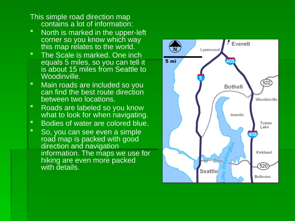
This simple road direction map contains a lot of information:
North is marked in the upper-left corner so you know which way this map relates to the world.
The Scale is marked. One inch equals 5 miles, so you can tell it is about 15 miles from Seattle to Woodinville.
Main roads are included so you can find the best route direction between two locations.
Roads are labeled so you know what to look for when navigating.
Bodies of water are colored blue.
So, you can see even a simple road map is packed with good direction and navigation information. The maps we use for hiking are even more packed with details.<br>
North is marked in the upper-left corner so you know which way this map relates to the world.
The Scale is marked. One inch equals 5 miles, so you can tell it is about 15 miles from Seattle to Woodinville.
Main roads are included so you can find the best route direction between two locations.
Roads are labeled so you know what to look for when navigating.
Bodies of water are colored blue.
So, you can see even a simple road map is packed with good direction and navigation information. The maps we use for hiking are even more packed with details.<br>
03
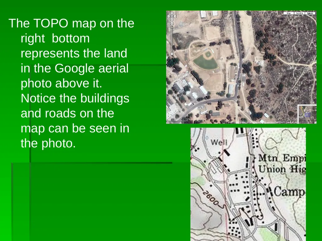
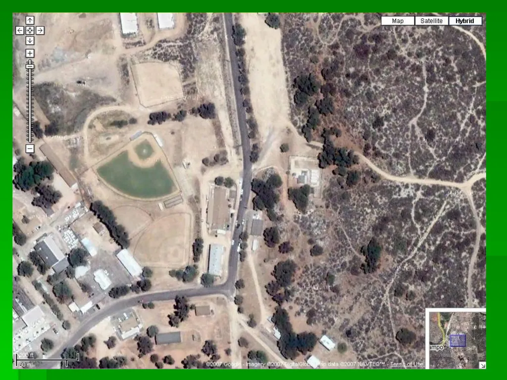
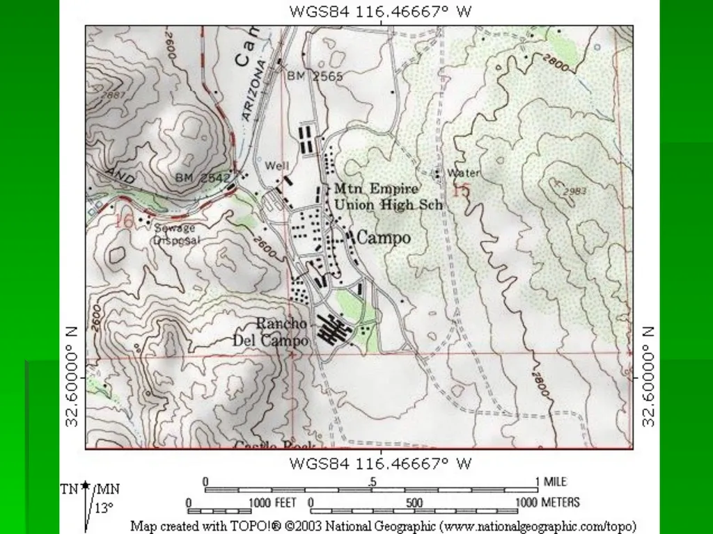
The TOPO map on the right bottom represents the land in the Google aerial photo above it. Notice the buildings and roads on the map can be seen in the photo.<br>
04
Latitude
If you could stand at the center of the earth, you could look out at the surface of the earth all around you. With the North Pole directly above your head, if you looked straight ahead in any direction, you would be looking at the equator. This imaginary line is exactly halfway between the north and south poles and has a latitude of 0 degrees because you are looking straight ahead at an angle of 0 degrees. If you look up a bit, maybe at an angle of 30 degrees, you have increased your latitude to 30 degrees North. Continue to look up higher and higher until you are looking straight above you at the north pole which is 90 degrees North.<br>
05
Longitude
Longitude is the angle east or west around the earth, just like latitude is the angle north and south. Longitude lines are called meridians.
For latitudes, we have two fixed points - the north and south poles - that we use as end points. But, going around the earth, there is no start or stop, it just keeps spinning and spinning. So, an arbitrary spot was chosen to be the Start point for longitudes. This spot is the Royal Observatory in Greenwich, UK. The longitude line that runs through it is called the Prime Meridian and is longitude zero degrees. ( it’s also the place where Greenwich mean time starts.) Notice that longitude lines are not parallel. The closer to the poles you get, the shorter the distance between meridians until they all actually converge at the poles.<br>
For latitudes, we have two fixed points - the north and south poles - that we use as end points. But, going around the earth, there is no start or stop, it just keeps spinning and spinning. So, an arbitrary spot was chosen to be the Start point for longitudes. This spot is the Royal Observatory in Greenwich, UK. The longitude line that runs through it is called the Prime Meridian and is longitude zero degrees. ( it’s also the place where Greenwich mean time starts.) Notice that longitude lines are not parallel. The closer to the poles you get, the shorter the distance between meridians until they all actually converge at the poles.<br>
06
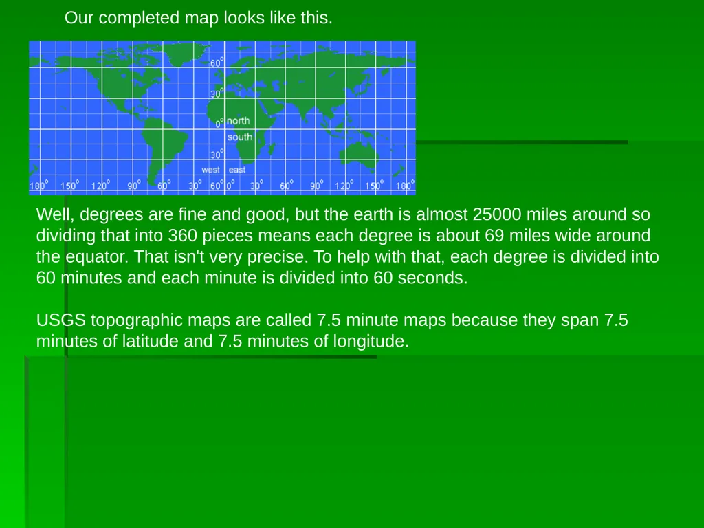
Our completed map looks like this. Well, degrees are fine and good, but the earth is almost 25000 miles around so dividing that into 360 pieces means each degree is about 69 miles wide around the equator. That isn't very precise. To help with that, each degree is divided into 60 minutes and each minute is divided into 60 seconds.
USGS topographic maps are called 7.5 minute maps because they span 7.5 minutes of latitude and 7.5 minutes of longitude.<br>
USGS topographic maps are called 7.5 minute maps because they span 7.5 minutes of latitude and 7.5 minutes of longitude.<br>
07
Latitude & Longitude (Refer to your TOPO MAP)
Latitude and longitude is the most common grid system used for navigation. It will allow you to pinpoint your location with a high degree of accuracy. Latitude is angular distance measured north and south of the Equator. The Equator is 0 degrees. As you go north of the equator the, latitude increases all the way up to 90 degrees at the north pole. If you go south of the equator, the latitude increases all the way up to 90 degrees at the south pole. In the northern hemisphere the latitude is always given in degrees north and in the southern hemisphere it is given in degrees south.
Longitude works the same way. It is angular distance measured east and west of the Prime Meridian. The prime meridian is 0 degrees longitude. As you go east from the prime meridian, the longitude increases to 180 degrees. As you go west from the prime meridian longitude increases to 180 degrees. The 180 degree meridian is also known as the international date line. In the eastern hemisphere the longitude is given in degrees east and in the western hemisphere it is given in degrees west.<br>
Latitude and longitude is the most common grid system used for navigation. It will allow you to pinpoint your location with a high degree of accuracy. Latitude is angular distance measured north and south of the Equator. The Equator is 0 degrees. As you go north of the equator the, latitude increases all the way up to 90 degrees at the north pole. If you go south of the equator, the latitude increases all the way up to 90 degrees at the south pole. In the northern hemisphere the latitude is always given in degrees north and in the southern hemisphere it is given in degrees south.
Longitude works the same way. It is angular distance measured east and west of the Prime Meridian. The prime meridian is 0 degrees longitude. As you go east from the prime meridian, the longitude increases to 180 degrees. As you go west from the prime meridian longitude increases to 180 degrees. The 180 degree meridian is also known as the international date line. In the eastern hemisphere the longitude is given in degrees east and in the western hemisphere it is given in degrees west.<br>
08
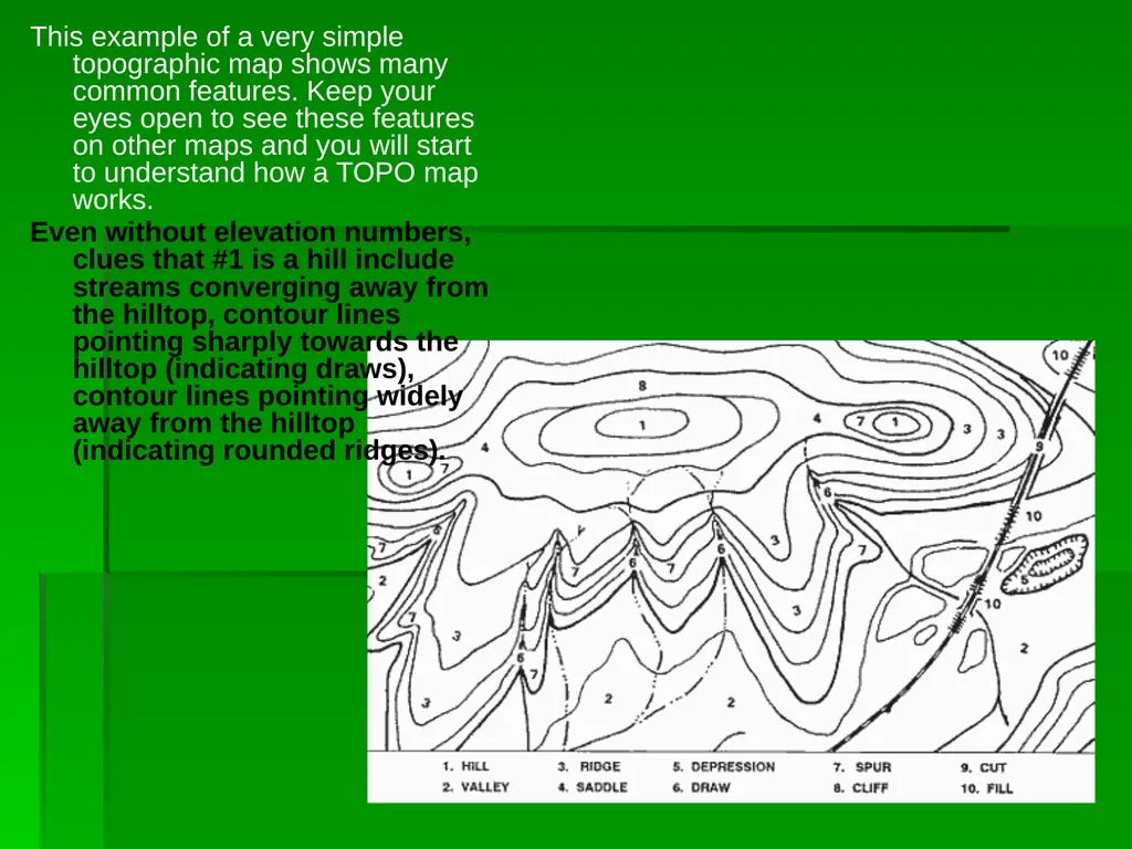
This example of a very simple topographic map shows many common features. Keep your eyes open to see these features on other maps and you will start to understand how a TOPO map works.
Even without elevation numbers, clues that #1 is a hill include streams converging away from the hilltop, contour lines pointing sharply towards the hilltop (indicating draws), contour lines pointing widely away from the hilltop (indicating rounded ridges).<br>
Even without elevation numbers, clues that #1 is a hill include streams converging away from the hilltop, contour lines pointing sharply towards the hilltop (indicating draws), contour lines pointing widely away from the hilltop (indicating rounded ridges).<br>
09
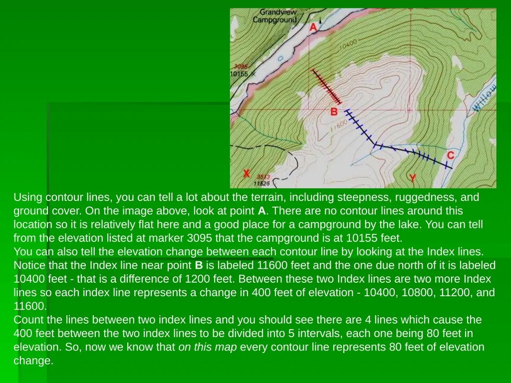
Using contour lines, you can tell a lot about the terrain, including steepness, ruggedness, and ground cover. On the image above, look at point A. There are no contour lines around this location so it is relatively flat here and a good place for a campground by the lake. You can tell from the elevation listed at marker 3095 that the campground is at 10155 feet.
You can also tell the elevation change between each contour line by looking at the Index lines. Notice that the Index line near point B is labeled 11600 feet and the one due north of it is labeled 10400 feet - that is a difference of 1200 feet. Between these two Index lines are two more Index lines so each index line represents a change in 400 feet of elevation - 10400, 10800, 11200, and 11600. Count the lines between two index lines and you should see there are 4 lines which cause the 400 feet between the two index lines to be divided into 5 intervals, each one being 80 feet in elevation. So, now we know that on this map every contour line represents 80 feet of elevation change.<br>
You can also tell the elevation change between each contour line by looking at the Index lines. Notice that the Index line near point B is labeled 11600 feet and the one due north of it is labeled 10400 feet - that is a difference of 1200 feet. Between these two Index lines are two more Index lines so each index line represents a change in 400 feet of elevation - 10400, 10800, 11200, and 11600. Count the lines between two index lines and you should see there are 4 lines which cause the 400 feet between the two index lines to be divided into 5 intervals, each one being 80 feet in elevation. So, now we know that on this map every contour line represents 80 feet of elevation change.<br>
10
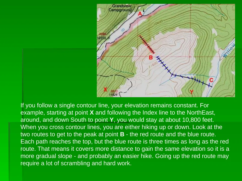
If you follow a single contour line, your elevation remains constant. For example, starting at point X and following the Index line to the NorthEast, around, and down South to point Y, you would stay at about 10,800 feet.
When you cross contour lines, you are either hiking up or down. Look at the two routes to get to the peak at point B - the red route and the blue route. Each path reaches the top, but the blue route is three times as long as the red route. That means it covers more distance to gain the same elevation so it is a more gradual slope - and probably an easier hike. Going up the red route may require a lot of scrambling and hard work.<br>
When you cross contour lines, you are either hiking up or down. Look at the two routes to get to the peak at point B - the red route and the blue route. Each path reaches the top, but the blue route is three times as long as the red route. That means it covers more distance to gain the same elevation so it is a more gradual slope - and probably an easier hike. Going up the red route may require a lot of scrambling and hard work.<br>
11
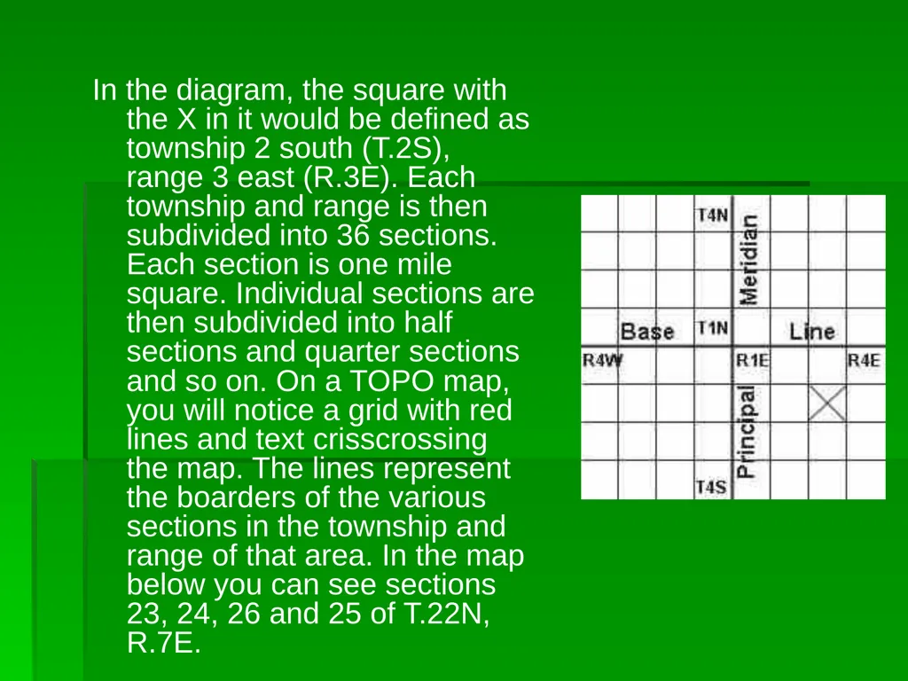
Township and Range System The Township and Range system, sometimes called the Public Lands Survey System, was developed to help parcel out western lands as the country expanded. The system takes many western states and divides them up using a base line and a principal meridian. As you go to the east or west of the principal meridian, the range increases in that direction. If you go north or south of the base line, the township increases. This system divides the land up into townships and ranges that are 36 square miles each.<br>
12
In the diagram, the square with the X in it would be defined as township 2 south (T.2S), range 3 east (R.3E). Each township and range is then subdivided into 36 sections. Each section is one mile square. Individual sections are then subdivided into half sections and quarter sections and so on. On a TOPO map, you will notice a grid with red lines and text crisscrossing the map. The lines represent the boarders of the various sections in the township and range of that area. In the map below you can see sections 23, 24, 26 and 25 of T.22N, R.7E.<br>
13
Map Scale Any scale can be used for a map, but a few common scales have been settled on for use by most organizations:
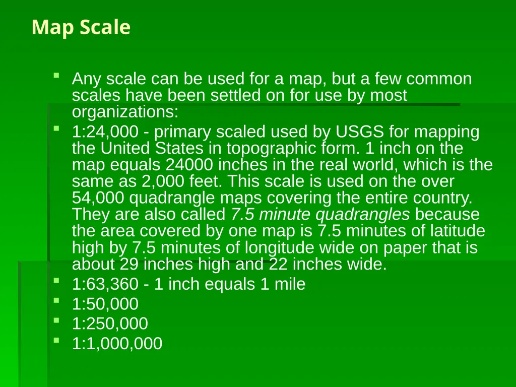
1:24,000 - primary scaled used by USGS for mapping the United States in topographic form. 1 inch on the map equals 24000 inches in the real world, which is the same as 2,000 feet. This scale is used on the over 54,000 quadrangle maps covering the entire country. They are also called 7.5 minute quadrangles because the area covered by one map is 7.5 minutes of latitude high by 7.5 minutes of longitude wide on paper that is about 29 inches high and 22 inches wide.
1:63,360 - 1 inch equals 1 mile
1:50,000
1:250,000
1:1,000,000<br>
1:24,000 - primary scaled used by USGS for mapping the United States in topographic form. 1 inch on the map equals 24000 inches in the real world, which is the same as 2,000 feet. This scale is used on the over 54,000 quadrangle maps covering the entire country. They are also called 7.5 minute quadrangles because the area covered by one map is 7.5 minutes of latitude high by 7.5 minutes of longitude wide on paper that is about 29 inches high and 22 inches wide.
1:63,360 - 1 inch equals 1 mile
1:50,000
1:250,000
1:1,000,000<br>
14
The smaller the number on the bottom of the map scale, the more detailed the map will be. A 1:10,000 map will show objects ten times as large as a 1:100,000 map but will only show 1/10th the land area on the same sized piece of paper.
Here is an example of a Bar Scale found on a map. The scale shows that about 1.25 inches equals 5 miles. The smaller increments to the left of zero are each 1 mile and are used to estimate smaller distances. Notice the scale is 1/250000 - that means 1 inch on the map is equal to 250,000 inches on the real land. (5 miles = 5*5280 feet = 5*5280*12 inches = 316800 inches. 316800 inches / 250000 = 1.27 inches)
By including a map scale like the image below, if the map is photocopied and reduced in size, the scale can still be used. Otherwise, 1 inch would no longer equal what it should.<br>
Here is an example of a Bar Scale found on a map. The scale shows that about 1.25 inches equals 5 miles. The smaller increments to the left of zero are each 1 mile and are used to estimate smaller distances. Notice the scale is 1/250000 - that means 1 inch on the map is equal to 250,000 inches on the real land. (5 miles = 5*5280 feet = 5*5280*12 inches = 316800 inches. 316800 inches / 250000 = 1.27 inches)
By including a map scale like the image below, if the map is photocopied and reduced in size, the scale can still be used. Otherwise, 1 inch would no longer equal what it should.<br>
15
Large scale maps or small scale maps.
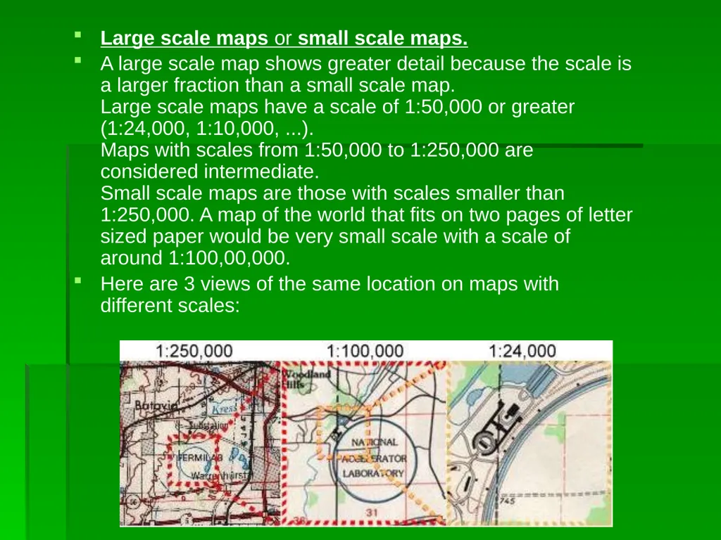
A large scale map shows greater detail because the scale is a larger fraction than a small scale map. Large scale maps have a scale of 1:50,000 or greater (1:24,000, 1:10,000, ...). Maps with scales from 1:50,000 to 1:250,000 are considered intermediate. Small scale maps are those with scales smaller than 1:250,000. A map of the world that fits on two pages of letter sized paper would be very small scale with a scale of around 1:100,00,000.
Here are 3 views of the same location on maps with different scales:<br>
A large scale map shows greater detail because the scale is a larger fraction than a small scale map. Large scale maps have a scale of 1:50,000 or greater (1:24,000, 1:10,000, ...). Maps with scales from 1:50,000 to 1:250,000 are considered intermediate. Small scale maps are those with scales smaller than 1:250,000. A map of the world that fits on two pages of letter sized paper would be very small scale with a scale of around 1:100,00,000.
Here are 3 views of the same location on maps with different scales:<br>
16
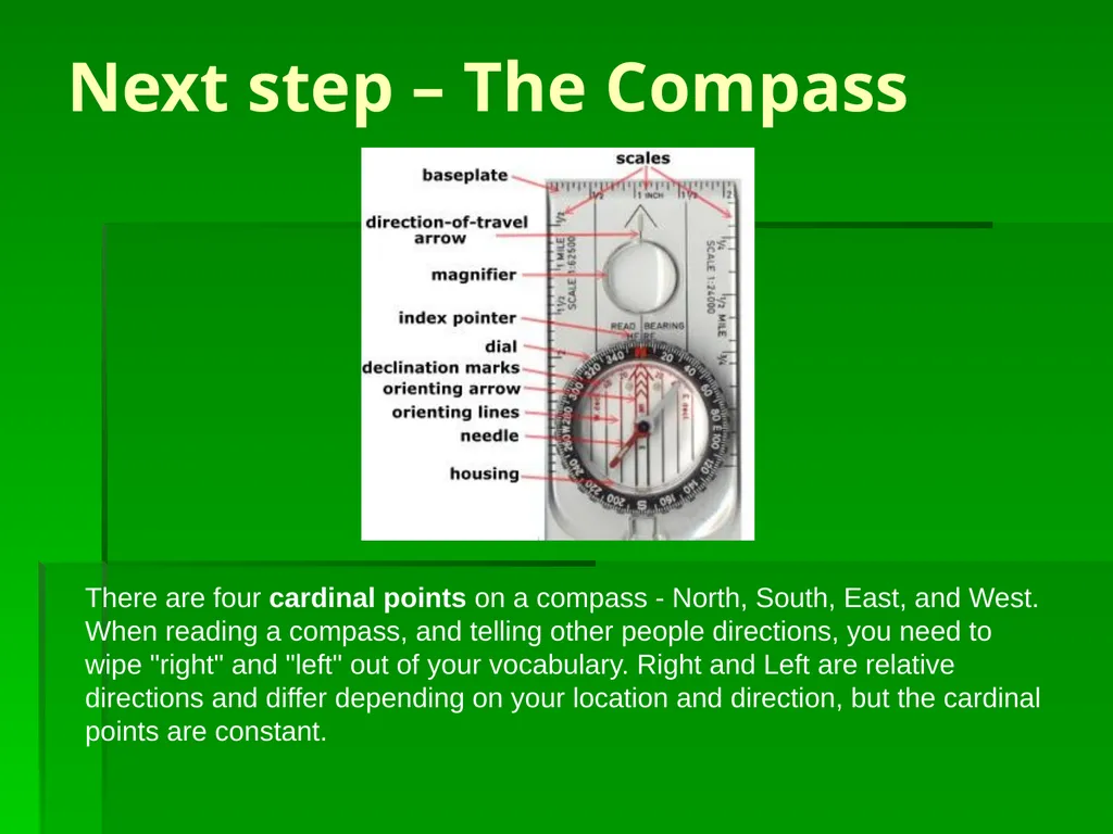
Next step – The Compass There are four cardinal points on a compass - North, South, East, and West. When reading a compass, and telling other people directions, you need to wipe "right" and "left" out of your vocabulary. Right and Left are relative directions and differ depending on your location and direction, but the cardinal points are constant.<br>
17
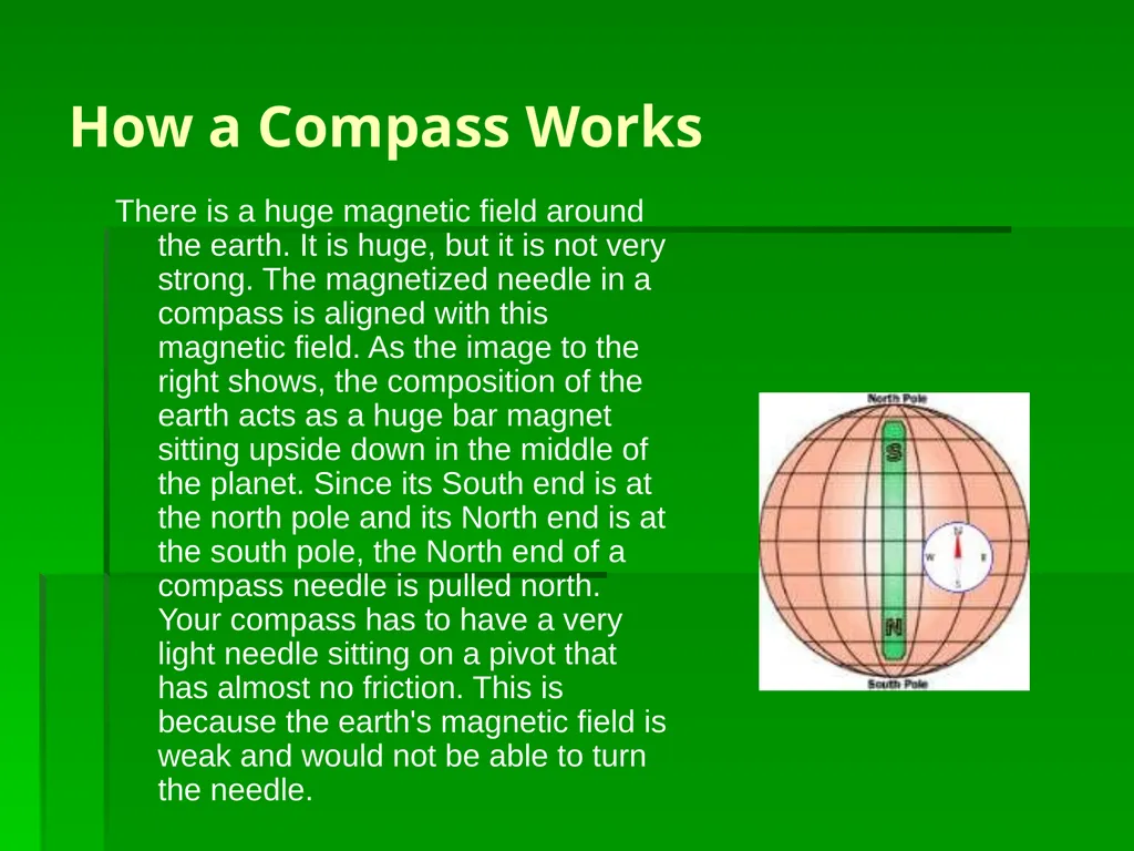
How a Compass Works There is a huge magnetic field around the earth. It is huge, but it is not very strong. The magnetized needle in a compass is aligned with this magnetic field. As the image to the right shows, the composition of the earth acts as a huge bar magnet sitting upside down in the middle of the planet. Since its South end is at the north pole and its North end is at the south pole, the North end of a compass needle is pulled north. Your compass has to have a very light needle sitting on a pivot that has almost no friction. This is because the earth's magnetic field is weak and would not be able to turn the needle.<br>
18
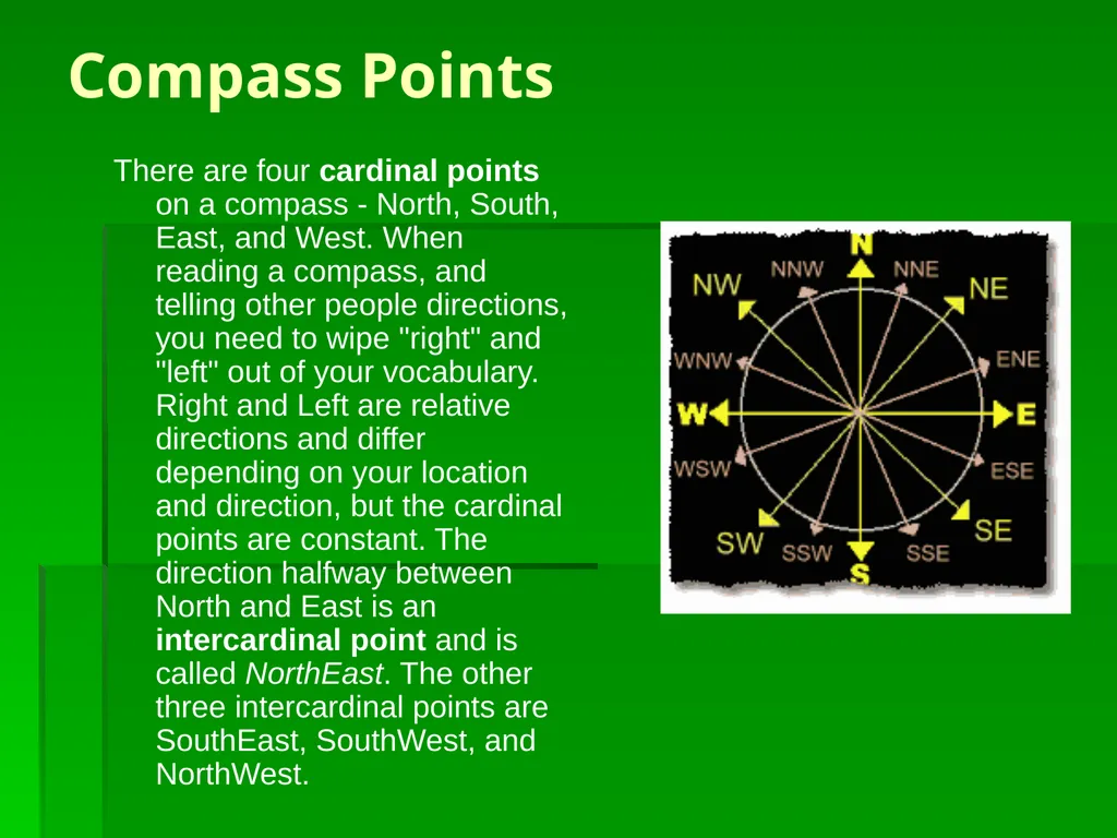
Compass Points There are four cardinal points on a compass - North, South, East, and West. When reading a compass, and telling other people directions, you need to wipe "right" and "left" out of your vocabulary. Right and Left are relative directions and differ depending on your location and direction, but the cardinal points are constant. The direction halfway between North and East is an intercardinal point and is called NorthEast. The other three intercardinal points are SouthEast, SouthWest, and NorthWest.<br>
19
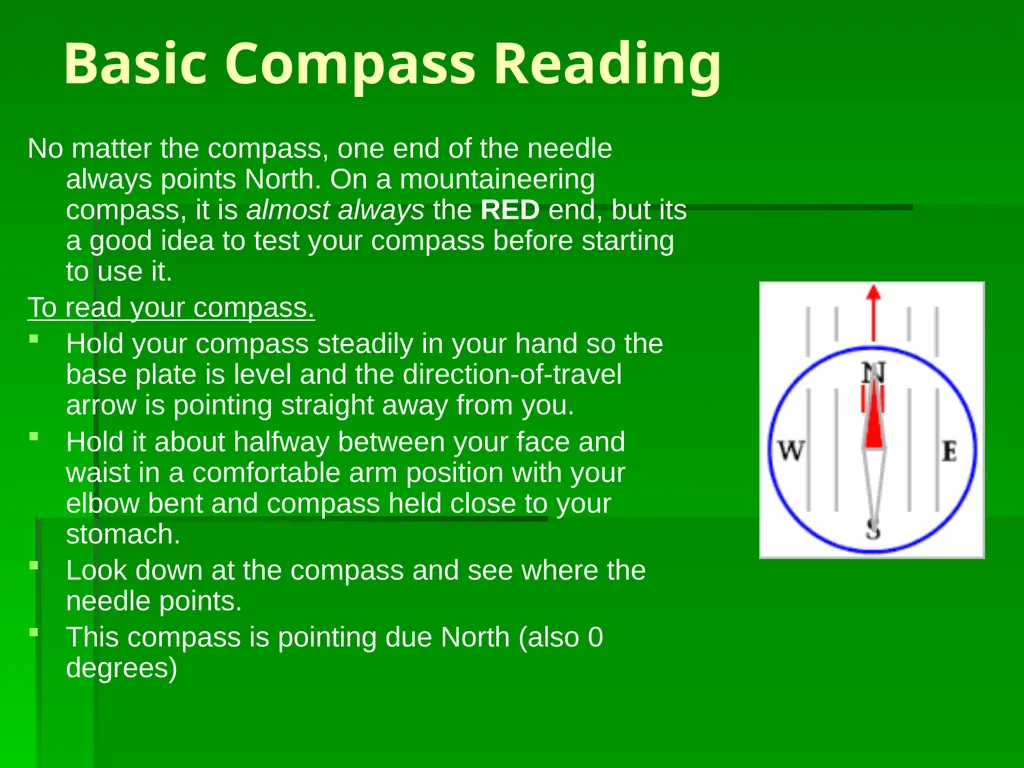
Basic Compass Reading No matter the compass, one end of the needle always points North. On a mountaineering compass, it is almost always the RED end, but its a good idea to test your compass before starting to use it.
To read your compass.
Hold your compass steadily in your hand so the base plate is level and the direction-of-travel arrow is pointing straight away from you.
Hold it about halfway between your face and waist in a comfortable arm position with your elbow bent and compass held close to your stomach.
Look down at the compass and see where the needle points.
This compass is pointing due North (also 0 degrees)<br>
To read your compass.
Hold your compass steadily in your hand so the base plate is level and the direction-of-travel arrow is pointing straight away from you.
Hold it about halfway between your face and waist in a comfortable arm position with your elbow bent and compass held close to your stomach.
Look down at the compass and see where the needle points.
This compass is pointing due North (also 0 degrees)<br>
20
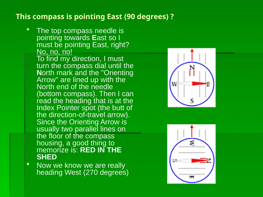
This compass is pointing East (90 degrees) ? The top compass needle is pointing towards East so I must be pointing East, right? No, no, no!
To find my direction, I must turn the compass dial until the North mark and the "Orienting Arrow" are lined up with the North end of the needle (bottom compass). Then I can read the heading that is at the Index Pointer spot (the butt of the direction-of-travel arrow).
Since the Orienting Arrow is usually two parallel lines on the floor of the compass housing, a good thing to memorize is: RED IN THE SHED
Now we know we are really heading West (270 degrees)<br>
Now we know we are really heading West (270 degrees)<br>
21
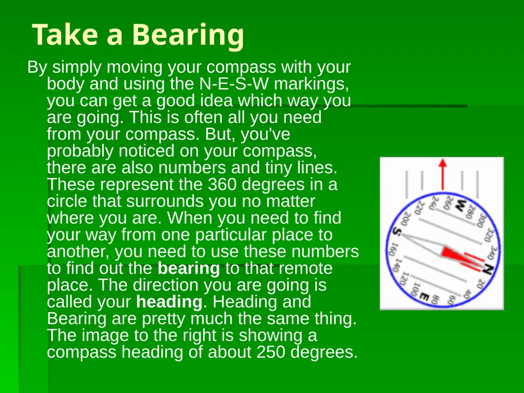
Take a Bearing By simply moving your compass with your body and using the N-E-S-W markings, you can get a good idea which way you are going. This is often all you need from your compass. But, you've probably noticed on your compass, there are also numbers and tiny lines. These represent the 360 degrees in a circle that surrounds you no matter where you are. When you need to find your way from one particular place to another, you need to use these numbers to find out the bearing to that remote place. The direction you are going is called your heading. Heading and Bearing are pretty much the same thing. The image to the right is showing a compass heading of about 250 degrees.<br>
22
Determining the bearing to an object is just like finding your heading. Turn to face the object and do the steps for determining your heading. Here's a simple exercise to try...
On a hike in Wyoming, you see a strange rock formation off in the distance. Using your compass, you take a bearing to it as shown top right.
Learning how to use a compass to follow a line of travel is simply pausing to take a reading occasionally while hiking. In the picture below right, you're trying to find your way to the lake in the distance to refill your water supply. In this opening in the forest, you pause to take a bearing to the lake and see that it is about 220 degrees. Ahead of you, there is no trail and you drop into thick forest. You won't be able to see the lake or easy landmarks for quite awhile. As you walk, you need to occasionally check your heading on the compass to ensure you are still heading 220 degrees.<br>
On a hike in Wyoming, you see a strange rock formation off in the distance. Using your compass, you take a bearing to it as shown top right.
Learning how to use a compass to follow a line of travel is simply pausing to take a reading occasionally while hiking. In the picture below right, you're trying to find your way to the lake in the distance to refill your water supply. In this opening in the forest, you pause to take a bearing to the lake and see that it is about 220 degrees. Ahead of you, there is no trail and you drop into thick forest. You won't be able to see the lake or easy landmarks for quite awhile. As you walk, you need to occasionally check your heading on the compass to ensure you are still heading 220 degrees.<br>
23
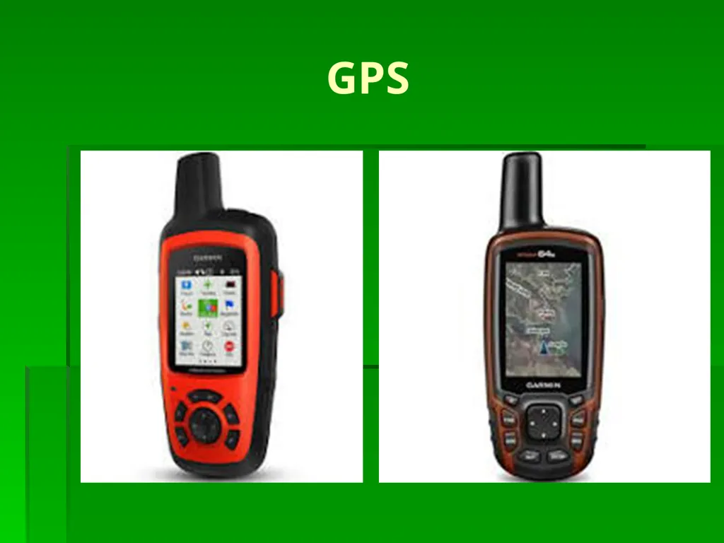
GPS<br>
24
ON X HUNT https://www.onxmaps.com<br>
25
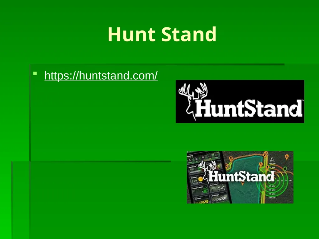
Hunt Stand https://huntstand.com/<br>