Empowering Small Farmers with Satellite Data in
1 / 1

Empowering Small Farmers with Satellite Data in

Author : phoebe-click | Published Date : 2025-05-10

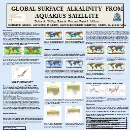
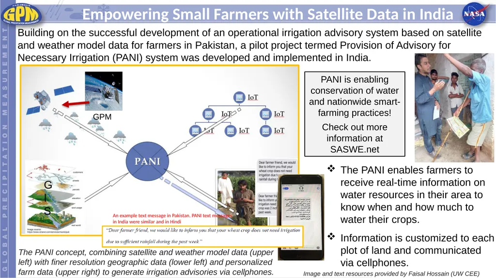
Description: Empowering Small Farmers with Satellite Data in India The PANI enables farmers to receive realtime information on water resources in their area to know when and how much to water their crops Information is customized to each plot of land

Presentation Embed Code

Download Presentation

Download Presentation The PPT/PDF document "Empowering Small Farmers with Satellite Data in" is the property of its rightful owner. Permission is granted to download and print the materials on this website for personal, non-commercial use only, and to display it on your personal computer provided you do not modify the materials and that you retain all copyright notices contained in the materials. By downloading content from our website, you accept the terms of this agreement.

Transcript:Empowering Small Farmers with Satellite Data in:
Empowering Small Farmers with Satellite Data in India The PANI enables farmers to receive real-time information on water resources in their area to know when and how much to water their crops. Information is customized to each plot of land and communicated via cellphones. The PANI concept, combining satellite and weather model data (upper left) with finer resolution geographic data (lower left) and personalized farm data (upper right) to generate irrigation advisories via cellphones. Building on the successful development of an operational irrigation advisory system based on satellite and weather model data for farmers in Pakistan, a pilot project termed Provision of Advisory for Necessary Irrigation (PANI) system was developed and implemented in India. PANI is enabling conservation of water and nationwide smart-farming practices! Check out more information at SASWE.net Image and text resources provided by Faisal Hossain (UW CEE) An example text message in Pakistan. PANI text messages in India were similar and in Hindi

Download Document

Here is the link to download the presentation.
"Empowering Small Farmers with Satellite Data in"The content belongs to its owner. You may download and print it for personal use, without modification, and keep all copyright notices. By downloading, you agree to these terms.

Related Presentations

Aircraft/Satellite comparisons from the HIPPO and Use of satellite data in the JRA-55 reanalysis and Satellite Design Workshop 1 User Services and Support for NESDIS Satellite Products a “EMPOWERING WOMEN CAPITAL” Satellite Design Workshop Research to Operations of New and Enhanced NESDIS Satellite Products Silicon Flatirons Drone and Satellite Primer Small Satellite Regulatory Issues: Data Security  Superior Small Moving Company Near Me First-class small movers near me Small long distance moves | Ship Smart Inc. Small moving companies | Ship Smart Inc.