Mapping tidal flat topography using ICESat-2 and
1 / 1

Mapping tidal flat topography using ICESat-2 and

Author : alexa-scheidler | Published Date : 2026-06-17

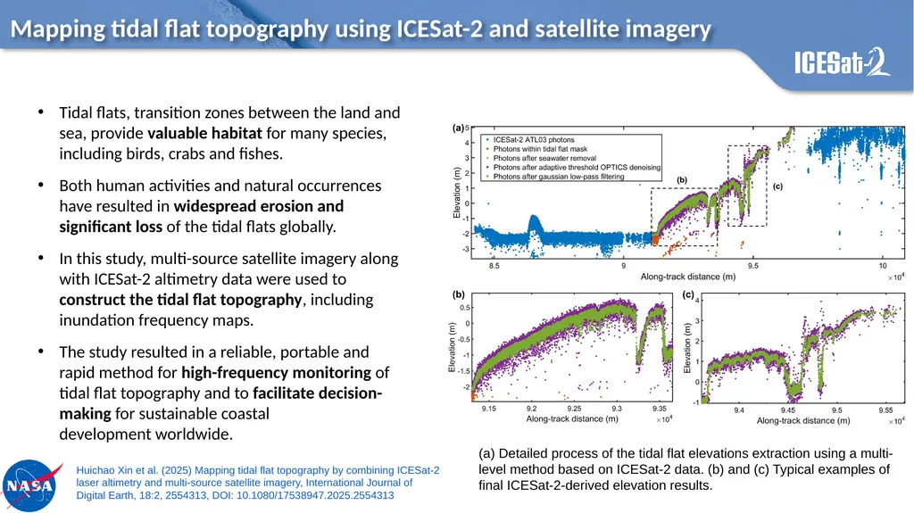
Description: Mapping tidal flat topography using ICESat-2 and satellite imagery (a) Detailed process of the tidal flat elevations extraction using a multi-level method based on ICESat-2 data. (b) and (c) Typical examples of final ICESat-2-derived

Presentation Embed Code

Download Presentation

Download Presentation The PPT/PDF document "" is the property of its rightful owner. Permission is granted to download and print the materials on this website for personal, non-commercial use only, and to display it on your personal computer provided you do not modify the materials and that you retain all copyright notices contained in the materials. By downloading content from our website, you accept the terms of this agreement.

Transcript:
Loading transcript�

Download Document

Here is the link to download the presentation.
"Mapping tidal flat topography using ICESat-2 and"The content belongs to its owner. You may download and print it for personal use, without modification, and keep all copyright notices. By downloading, you agree to these terms.

Related Presentations

Wave and tidal
Wave and tidal
On The Interaction of Tidal Power Extraction and Natural En
Tidal
Tidal
Tides, King Tides, and Tidal
Agenda, Part II TIDAL DATUMS in the South SF Bay
A Methodology for a Decision Support Tool for a Tidal Stream Device
Flat Belly Fix PDF, eBook by Todd Lamb
Concept Mapping Mind Mapping and Argument Mapping The University of
Modelling the salinity response to fresh water flow and variable tidal amplitude i...
Tidal Alignments & Large Scale Structure
Figure:  A national scale relative tidal elevation (Z*) mapping product displayed ...
Figure: A national scale relative tidal elevation (Z*) mapping product displayed ...
Tidal Flat Environments Tides are a complex product of gravitational attraction (f...
PART 6 TOPOGRAPHY WHAT IS TOPOGRAPHY? Topography
Mapping tidal flat topography using ICESat-2 and