
Presentation to Expert Appraisal Committee(EAC)
PC
Published · 53 slides · 0 views
1 / 1
Description
Presentation to Expert Appraisal Committee(EAC) For Proposed Deepening Widening of Approach Channel to Second Chemical Berth at Pir Pau, Mumbai (ToR Compliance) By, MUMBAI PORT TRUST Proposal No: IAMHMIS711392017 Sr. no: Meeting No:
Related Topics
Share
Embed code
Download this presentation From Below
"Presentation to Expert Appraisal Committee(EAC)" is the property of its rightful owner. Permission is granted to download and print the materials on this website for personal, non-commercial use only, and to display it on your personal computer provided you do not modify the materials and that you retain all copyright notices contained in the materials. By downloading content from our website, you accept the terms of this agreement.
Presentation Transcript
01
Presentation to Expert Appraisal Committee(EAC)
For
Proposed Deepening & Widening of Approach Channel to Second Chemical Berth at Pir Pau, Mumbai
(ToR Compliance)
By,
MUMBAI PORT TRUST
Proposal No: IA/MH/MIS/71139/2017
Sr. no: Meeting No:
Date:<br>
For
Proposed Deepening & Widening of Approach Channel to Second Chemical Berth at Pir Pau, Mumbai
(ToR Compliance)
By,
MUMBAI PORT TRUST
Proposal No: IA/MH/MIS/71139/2017
Sr. no: Meeting No:
Date:<br>
02
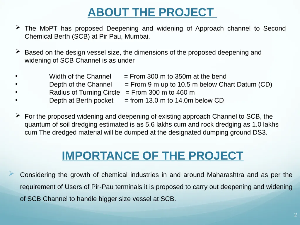
ABOUT THE PROJECT The MbPT has proposed Deepening and widening of Approach channel to Second Chemical Berth (SCB) at Pir Pau, Mumbai.
Based on the design vessel size, the dimensions of the proposed deepening and widening of SCB Channel is as under
Width of the Channel = From 300 m to 350m at the bend
Depth of the Channel = From 9 m up to 10.5 m below Chart Datum (CD)
Radius of Turning Circle = From 300 m to 460 m
Depth at Berth pocket = from 13.0 m to 14.0m below CD
For the proposed widening and deepening of existing approach Channel to SCB, the quantum of soil dredging estimated is as 5.6 lakhs cum and rock dredging as 1.0 lakhs cum The dredged material will be dumped at the designated dumping ground DS3. IMPORTANCE OF THE PROJECT Considering the growth of chemical industries in and around Maharashtra and as per the requirement of Users of Pir-Pau terminals it is proposed to carry out deepening and widening of SCB Channel to handle bigger size vessel at SCB.<br>
Based on the design vessel size, the dimensions of the proposed deepening and widening of SCB Channel is as under
Width of the Channel = From 300 m to 350m at the bend
Depth of the Channel = From 9 m up to 10.5 m below Chart Datum (CD)
Radius of Turning Circle = From 300 m to 460 m
Depth at Berth pocket = from 13.0 m to 14.0m below CD
For the proposed widening and deepening of existing approach Channel to SCB, the quantum of soil dredging estimated is as 5.6 lakhs cum and rock dredging as 1.0 lakhs cum The dredged material will be dumped at the designated dumping ground DS3. IMPORTANCE OF THE PROJECT Considering the growth of chemical industries in and around Maharashtra and as per the requirement of Users of Pir-Pau terminals it is proposed to carry out deepening and widening of SCB Channel to handle bigger size vessel at SCB.<br>
03
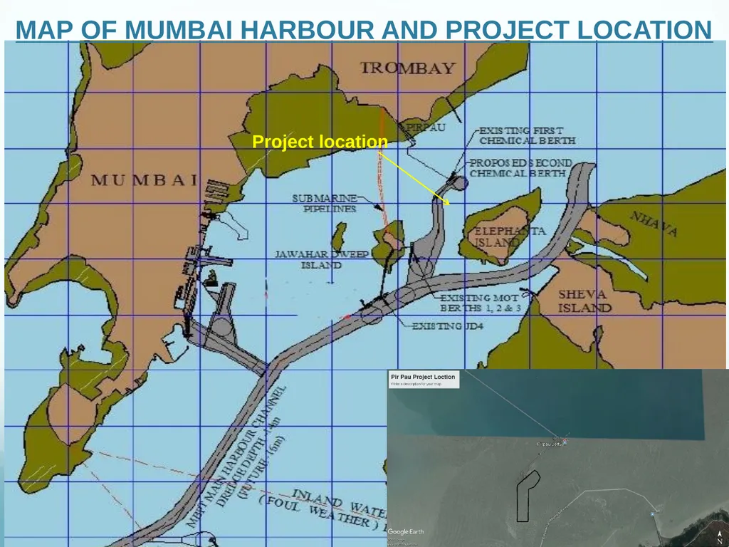
MAP OF MUMBAI HARBOUR AND PROJECT LOCATION Project location<br>
04
Background of the project The proposal for grant of Terms of Reference (ToR) to the project 'Deepening and Widening of Approach Channel to Second Chemical Berth SCB at Pir Pau, Mumbai Port water area, Mahul, Mumbai, Maharashtra promoted by M/s Mumbai Port Trust was considered by the Expert Appraisal Committee (Infra-2) in its 26th meeting held on 14-15 December, 2017. on 22.03.2018 and the ToR letter recieved on 22.03.2018
The required Public Hearing has been carried out as per the Terms of Reference (ToR) through MPCB and Hon Collector office after grant of CRZ recommendations from MCZMA
MCZMA recommended the projet to MoEF & CC in its 131st meeting held on 06.03.2019<br>
The required Public Hearing has been carried out as per the Terms of Reference (ToR) through MPCB and Hon Collector office after grant of CRZ recommendations from MCZMA
MCZMA recommended the projet to MoEF & CC in its 131st meeting held on 06.03.2019<br>
05
COMPLIANCE TO ADDITIONAL TERMS OF RREFERENCE Point 1: Importance and benefits of the project.
Reply:
Increased depth and width of the channel will cater the need of larger new generation vessels to board at MbPT.
Time will be saved due to better movement by vessels.
Fright cost will be reduced due to larger vessels.
The development is envisaged to play a significant role in strengthening connectivity along the Maharashtra coastline.
Enhancement in economy of Maharashtra.
Substantial positive impact on socio-economic profile of the area, in Particular, and Raigad, in general, both in terms of overall employment and skill development of local workforce
Direct as well as indirect employment potential is envisaged<br>
Reply:
Increased depth and width of the channel will cater the need of larger new generation vessels to board at MbPT.
Time will be saved due to better movement by vessels.
Fright cost will be reduced due to larger vessels.
The development is envisaged to play a significant role in strengthening connectivity along the Maharashtra coastline.
Enhancement in economy of Maharashtra.
Substantial positive impact on socio-economic profile of the area, in Particular, and Raigad, in general, both in terms of overall employment and skill development of local workforce
Direct as well as indirect employment potential is envisaged<br>
06
COMPLIANCE TO ADDITIONAL TERMS OF RREFERENCE Point 2: The EIA should specifically address to the environmental impacts of drilling and blasting and give an analysis of alternatives along with mitigation plans
Reply:
Environmental impacts of drilling are as follows-
The deepening by additional 1m at berth pocket will have to be carried out either by cutter suction dredger or under controlled blasting to avoid damage to existing pile structures.
Dredging work in water cause resuspension of sediments and turbid water.
Dredging will cause high turbidity, removal of nutrient due to dredging, which would ultimately affect the marine flora and fauna.
Dredging disturb bottom sediments and induce resuspension, dispersal and settlement of such sediments. Dumping of dredged material directly alters bottom configuration and biota and may disperse toxic or harmful chemicals around the disposal site.
Due to the rock dredging and development port at an offshore location, marine life will be impacted. Cont..<br>
Reply:
Environmental impacts of drilling are as follows-
The deepening by additional 1m at berth pocket will have to be carried out either by cutter suction dredger or under controlled blasting to avoid damage to existing pile structures.
Dredging work in water cause resuspension of sediments and turbid water.
Dredging will cause high turbidity, removal of nutrient due to dredging, which would ultimately affect the marine flora and fauna.
Dredging disturb bottom sediments and induce resuspension, dispersal and settlement of such sediments. Dumping of dredged material directly alters bottom configuration and biota and may disperse toxic or harmful chemicals around the disposal site.
Due to the rock dredging and development port at an offshore location, marine life will be impacted. Cont..<br>
07
COMPLIANCE TO ADDITIONAL TERMS OF RREFERENCE MITIGATION MEASURE
Ground vibrations can be controlled by determining the right size of charges in relation to the drilling patterns and the firing sequence. Just like mitigating ground vibrations, the most effective way to reduce both the pressure and impulse of a shock wave is to reduce the charges through reduction of spacing between blast holes and charging fewer explosives in the rock.
Another method to mitigate the pressure of underwater shock waves is to use an air bubble curtain around the blasting zone. The air bubble curtain is produced by using perforated steel pipes, through which air is pumped and bubbles up to the surface. The shock waves in the water are partly absorbed in the bubbles – the air bubble curtain reduces the peak pressure of the shock but not the impulse of the wave.
The air bubble curtain is one method but other methods such as acoustic deterrent devices can also be utilised. The acoustic deterrent devices can emit specialised acoustic signals to safely and temporarily deter various marine fauna species from marine construction sites.<br>
Ground vibrations can be controlled by determining the right size of charges in relation to the drilling patterns and the firing sequence. Just like mitigating ground vibrations, the most effective way to reduce both the pressure and impulse of a shock wave is to reduce the charges through reduction of spacing between blast holes and charging fewer explosives in the rock.
Another method to mitigate the pressure of underwater shock waves is to use an air bubble curtain around the blasting zone. The air bubble curtain is produced by using perforated steel pipes, through which air is pumped and bubbles up to the surface. The shock waves in the water are partly absorbed in the bubbles – the air bubble curtain reduces the peak pressure of the shock but not the impulse of the wave.
The air bubble curtain is one method but other methods such as acoustic deterrent devices can also be utilised. The acoustic deterrent devices can emit specialised acoustic signals to safely and temporarily deter various marine fauna species from marine construction sites.<br>
08
COMPLIANCE TO ADDITIONAL TERMS OF RREFERENCE Point 3: A report on the impacts of dredging disposal on the DS-3 site along with the total holding capacity, the material already dumped and the spare capacities available for utilisation
Reply:
CWPRS have detailed dispertion studies on the Mathematical Model of Mumbai Harbour. They have concluded that the DS3 location which is on the 20m contour is most suitable and the dumping of material will have no adverse affect.
CWPRS also stated that the capacity of said location is 100 million cu. M. it is proposed to deposed of the dredged material at the dumping station DS3 identified and studied and recommended by the CWPRS, Pune the dumping station DS 3 is proposed to be utilized for the project of Mumbai Port Trust
CWPR Report hyperlink<br>
Reply:
CWPRS have detailed dispertion studies on the Mathematical Model of Mumbai Harbour. They have concluded that the DS3 location which is on the 20m contour is most suitable and the dumping of material will have no adverse affect.
CWPRS also stated that the capacity of said location is 100 million cu. M. it is proposed to deposed of the dredged material at the dumping station DS3 identified and studied and recommended by the CWPRS, Pune the dumping station DS 3 is proposed to be utilized for the project of Mumbai Port Trust
CWPR Report hyperlink<br>
09
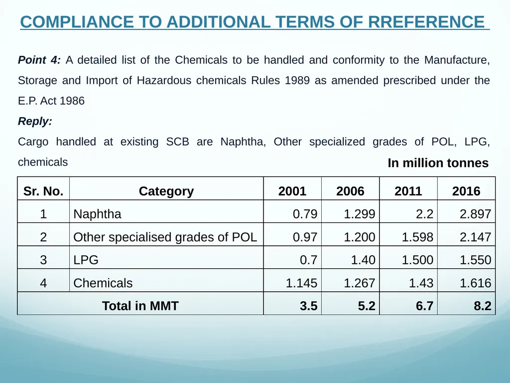
COMPLIANCE TO ADDITIONAL TERMS OF RREFERENCE Point 4: A detailed list of the Chemicals to be handled and conformity to the Manufacture, Storage and Import of Hazardous chemicals Rules 1989 as amended prescribed under the E.P. Act 1986
Reply:
Cargo handled at existing SCB are Naphtha, Other specialized grades of POL, LPG, chemicals In million tonnes<br>
Reply:
Cargo handled at existing SCB are Naphtha, Other specialized grades of POL, LPG, chemicals In million tonnes<br>
10
COMPLIANCE TO ADDITIONAL TERMS OF RREFERENCE Point 5: The E.l.A. should also submit a copy of the 'On site management plan' as prescribed under the MSIHC Rules of 1989
Reply:
Jetty Terminal Emergency Plan
This plan will be drawn up in consultation with port authority, fire brigade, coast guard and police etc. the major emergency expected is spillage leakage of flammable chemicals. POL products and liquefied gases through marine unloading arm/transfer pipeline at jetty. The plan will include:
Stopping or unloading operation immediately
Specific initial action 10 be taken by those at the location or ell1cricency (to notify time, position source and cause of spill) to control room and Coast guard
Immediate action to combat oil pollution
Evaluations of situation by on scene controller regarding threat posed by spill and identify threatened resources
Coordinated arrangement for quick and safe release of tanker in case or an emergency
Details or communication system available siren code Cont..<br>
Reply:
Jetty Terminal Emergency Plan
This plan will be drawn up in consultation with port authority, fire brigade, coast guard and police etc. the major emergency expected is spillage leakage of flammable chemicals. POL products and liquefied gases through marine unloading arm/transfer pipeline at jetty. The plan will include:
Stopping or unloading operation immediately
Specific initial action 10 be taken by those at the location or ell1cricency (to notify time, position source and cause of spill) to control room and Coast guard
Immediate action to combat oil pollution
Evaluations of situation by on scene controller regarding threat posed by spill and identify threatened resources
Coordinated arrangement for quick and safe release of tanker in case or an emergency
Details or communication system available siren code Cont..<br>
11
COMPLIANCE TO ADDITIONAL TERMS OF RREFERENCE An inventory, including location details of emergency equipment
Sound alarm-terminal fire fighting staff to fight fire
Unberth vessel to discharge
Mobilize-firefighting equipment
Electric power to switch off - emergency lighting to switch on
The ships calling at Jetty will be advised of the teminal emergency plan particularly the alarm signals and procedures to summon assistance in the event of an emergency on board. Cont..<br>
Sound alarm-terminal fire fighting staff to fight fire
Unberth vessel to discharge
Mobilize-firefighting equipment
Electric power to switch off - emergency lighting to switch on
The ships calling at Jetty will be advised of the teminal emergency plan particularly the alarm signals and procedures to summon assistance in the event of an emergency on board. Cont..<br>
12
COMPLIANCE TO ADDITIONAL TERMS OF RREFERENCE Tanker Emergency Plan
Planning and preparations are essential if personnel are to deal effectively with emergencies on board vessel. Though various types of emergencies can occur on the tanker, only fire on the terminal is of major concern in the present context. The immediate action to be taken by the master of the vessel will include:
Raising the alarm (also sound the terminal fire alarm to support ships effort to control fire) and commence shutting down and discharging, bunkering or deballasting operations which may be taking place
Harbour master will proceed to jetty and collect all information from master ship regarding emergency and pass the same to action group
Locate and assess the incident and assess possible dangers
Organize manpower and equipment for quick control of the incident
Coordinate arrangements for quick & safe release of the vessel
Terminal (Jetty) to suspend operations – disconnection of arm – clear terminal of unnecessary personnel . Cont..<br>
Planning and preparations are essential if personnel are to deal effectively with emergencies on board vessel. Though various types of emergencies can occur on the tanker, only fire on the terminal is of major concern in the present context. The immediate action to be taken by the master of the vessel will include:
Raising the alarm (also sound the terminal fire alarm to support ships effort to control fire) and commence shutting down and discharging, bunkering or deballasting operations which may be taking place
Harbour master will proceed to jetty and collect all information from master ship regarding emergency and pass the same to action group
Locate and assess the incident and assess possible dangers
Organize manpower and equipment for quick control of the incident
Coordinate arrangements for quick & safe release of the vessel
Terminal (Jetty) to suspend operations – disconnection of arm – clear terminal of unnecessary personnel . Cont..<br>
13
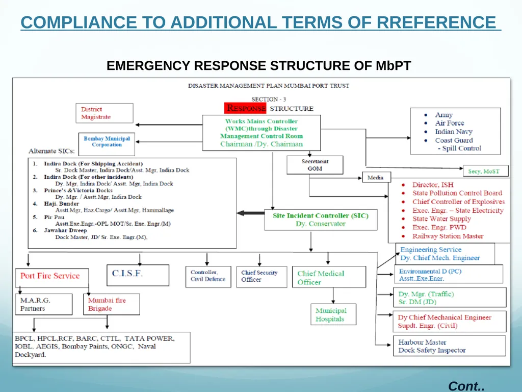
COMPLIANCE TO ADDITIONAL TERMS OF RREFERENCE EMERGENCY RESPONSE STRUCTURE OF MbPT Cont..<br>
14
COMPLIANCE TO ADDITIONAL TERMS OF RREFERENCE Point 6: Certified Compliance Report issued by the MoEF&CC, Regional Office or concerned Regional Office of Central Pollution Control Board or the Member Secretary of the respective State Pollution Control Board for the conditions stipulated in the earlier environmental clearance issued for the project along with an action taken report on issues which have been stated to be partially complied or non/not complied.
Reply:
Yes. The Compliance report is being submitted to MoEF every six month Point 7: Submit a complete set of documents required as per para 4.2 (i) of CRZ Notification, 2011: .
Reply: CRZ application documents are enclosed as Annexure -1<br>
Reply:
Yes. The Compliance report is being submitted to MoEF every six month Point 7: Submit a complete set of documents required as per para 4.2 (i) of CRZ Notification, 2011: .
Reply: CRZ application documents are enclosed as Annexure -1<br>
15
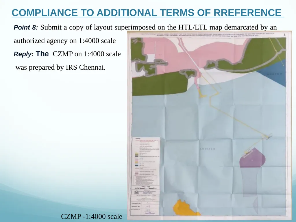
COMPLIANCE TO ADDITIONAL TERMS OF RREFERENCE Point 8: Submit a copy of layout superimposed on the HTL/LTL map demarcated by an authorized agency on 1:4000 scale
Reply: The CZMP on 1:4000 scale
was prepared by IRS Chennai. CZMP -1:4000 scale<br>
Reply: The CZMP on 1:4000 scale
was prepared by IRS Chennai. CZMP -1:4000 scale<br>
16
COMPLIANCE TO ADDITIONAL TERMS OF RREFERENCE Point 9: Recommendation of the SCZMA
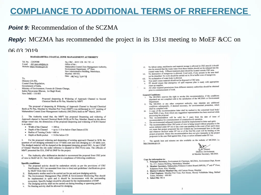
Reply: MCZMA has recommended the project in its 131st meeting to MoEF &CC on 06.03.2019<br>
Reply: MCZMA has recommended the project in its 131st meeting to MoEF &CC on 06.03.2019<br>
17
Point 10: Various Dock and shipbuilding facilities with capacities for existing and proposed project.
Reply: Not Applicable, since present proposal does not include the same. Point 11: List of cargo to be handled along with mode of transportation.
Reply:
Cargos handled at SCB are Naphtha, Other specialized grades of POL, LPG and Chemicals
The liquid cargo will be unloaded/ loaded by the MLAs and will be transported through extension of product pipelines from FCB to SCB.
The Chemical cargo will be unloaded/ loaded by the marine loading arms and will be transported through extension of product pipelines from 1st Chemical Berth to 2nd Chemical Berth COMPLIANCE TO ADDITIONAL TERMS OF RREFERENCE<br>
Reply: Not Applicable, since present proposal does not include the same. Point 11: List of cargo to be handled along with mode of transportation.
Reply:
Cargos handled at SCB are Naphtha, Other specialized grades of POL, LPG and Chemicals
The liquid cargo will be unloaded/ loaded by the MLAs and will be transported through extension of product pipelines from FCB to SCB.
The Chemical cargo will be unloaded/ loaded by the marine loading arms and will be transported through extension of product pipelines from 1st Chemical Berth to 2nd Chemical Berth COMPLIANCE TO ADDITIONAL TERMS OF RREFERENCE<br>
18
Point 12: Layout plan of existing and proposed Port.
Reply: Layout of SCB channel is as under COMPLIANCE TO ADDITIONAL TERMS OF RREFERENCE<br>
Reply: Layout of SCB channel is as under COMPLIANCE TO ADDITIONAL TERMS OF RREFERENCE<br>
19
Point 14: A detailed impact analysis of rock dredging
Reply: Possible impacts due to rock dredging are as follows
Ground vibration, which is the energy from the blast transmitted through the rock or ground, can occur from the blasting.
These vibrations are determined by various factors such as quantity of charges, characteristics of the rock and distance from the blast.
There is a risk of propagation between (blast) holes in underwater blasting. This could cause larger total charges to be detonated at the same time as well as stronger ground vibrations.
The energy from the blast can be transmitted in various directions in the water and at different frequencies – these frequencies are high at short distances but are reduced further from the blast.
Underwater shock waves are another impact from blasting that can cause damage to nearby structures, aquatic fauna and even vessels and people in the water. In water, the explosive energy is transmitted with great efficiency, which means that the shock wave has high destructive power even over large distances.
Moreover, the pressure of the shock waves is higher if the explosive is detonated freely in the water – the maximum pressure is 10 times higher if the explosive is detonated on a rock surface instead of a blast hole drilled into the rock COMPLIANCE TO ADDITIONAL TERMS OF RREFERENCE<br>
Reply: Possible impacts due to rock dredging are as follows
Ground vibration, which is the energy from the blast transmitted through the rock or ground, can occur from the blasting.
These vibrations are determined by various factors such as quantity of charges, characteristics of the rock and distance from the blast.
There is a risk of propagation between (blast) holes in underwater blasting. This could cause larger total charges to be detonated at the same time as well as stronger ground vibrations.
The energy from the blast can be transmitted in various directions in the water and at different frequencies – these frequencies are high at short distances but are reduced further from the blast.
Underwater shock waves are another impact from blasting that can cause damage to nearby structures, aquatic fauna and even vessels and people in the water. In water, the explosive energy is transmitted with great efficiency, which means that the shock wave has high destructive power even over large distances.
Moreover, the pressure of the shock waves is higher if the explosive is detonated freely in the water – the maximum pressure is 10 times higher if the explosive is detonated on a rock surface instead of a blast hole drilled into the rock COMPLIANCE TO ADDITIONAL TERMS OF RREFERENCE<br>
20
Point 15: The Air Quality Index shall be calculated for base level air quality
Reply: Baseline Ambient Air quality of the study area has been studied the details of the same are given as under COMPLIANCE TO ADDITIONAL TERMS OF RREFERENCE<br>
Reply: Baseline Ambient Air quality of the study area has been studied the details of the same are given as under COMPLIANCE TO ADDITIONAL TERMS OF RREFERENCE<br>
21
COMPLIANCE TO ADDITIONAL TERMS OF RREFERENCE Observation and Conclusion The status of the ambient air quality in the study area was established by carrying out monitoring for air quality parameters like PM2.5, PM10, SO2, NOX, CO, Pb, O3, As, Benzne, BaP etc. at 8 locations in the study area. The data presented is average for 24 hours.
Sulphur Dioxide (SO2)
The average value of the SO2 within study observed was 19.9 µg/m3. The maximum average value of SO2 was 21.5 µg/m3 at JNPT and minimum of 18.1 µg/m3 at Gharapuri. The SO2 values are below permissible level of 80µg/m3.
Oxides of Nitrogen (NOx)
The average value of the NOx within study observed was 20.8 µg/m3. The maximum average value of NOx was 22.9 µg/m3 at JNPT and minimum of 18.9 µg/m3 at Gharapuri. The NOx values are below permissible level 80µg/m3.
Particulate Matter (PM10)
PM10 values within study area was below permissible level of 100 µg/m3. The average value of PM10 recorded at site was 66.0 µg/m3. The maximum value of 68.9 µg/m3 and a minimum 62.5 µg/m3 were recorded at Gharapuri & Nhava Khadi respectively in the study area.
Particulate Matter (PM2.5)
PM2.5 values within study area were below permissible level of 6 µg/m3. The maximum 42.9 µg/m3 and a minimum 39.5 µg/m3 were recorded at Fort & Nhava khadi respectively in the study area. The average value of 40.5 µg/m3 was observed within study area. The values of the PM2.5 withtin study area were well below the limiting standards.
Ammonia (NH3)
Ammonia values within study area was below permissible level of 400 µg/m3. The average value of NH3 recorded at site was 5.0 µg/m3. The maximum value of 5.2 µg/m3 and a minimum 4.8 µg/m3 were recorded at Sewri & Chembur respectively in the study area.<br>
Sulphur Dioxide (SO2)
The average value of the SO2 within study observed was 19.9 µg/m3. The maximum average value of SO2 was 21.5 µg/m3 at JNPT and minimum of 18.1 µg/m3 at Gharapuri. The SO2 values are below permissible level of 80µg/m3.
Oxides of Nitrogen (NOx)
The average value of the NOx within study observed was 20.8 µg/m3. The maximum average value of NOx was 22.9 µg/m3 at JNPT and minimum of 18.9 µg/m3 at Gharapuri. The NOx values are below permissible level 80µg/m3.
Particulate Matter (PM10)
PM10 values within study area was below permissible level of 100 µg/m3. The average value of PM10 recorded at site was 66.0 µg/m3. The maximum value of 68.9 µg/m3 and a minimum 62.5 µg/m3 were recorded at Gharapuri & Nhava Khadi respectively in the study area.
Particulate Matter (PM2.5)
PM2.5 values within study area were below permissible level of 6 µg/m3. The maximum 42.9 µg/m3 and a minimum 39.5 µg/m3 were recorded at Fort & Nhava khadi respectively in the study area. The average value of 40.5 µg/m3 was observed within study area. The values of the PM2.5 withtin study area were well below the limiting standards.
Ammonia (NH3)
Ammonia values within study area was below permissible level of 400 µg/m3. The average value of NH3 recorded at site was 5.0 µg/m3. The maximum value of 5.2 µg/m3 and a minimum 4.8 µg/m3 were recorded at Sewri & Chembur respectively in the study area.<br>
22
Point 16: Study the impact of dredging and dumping on marine ecology and draw up a management plan through the NIO or any other institute specializing in marine ecology
Reply: Marine Ecological Impact Assessment Studies was conducted in January 2018 by NIO . COMPLIANCE TO ADDITIONAL TERMS OF RREFERENCE Marine Ecological Impact Assessment report hyperlink<br>
Reply: Marine Ecological Impact Assessment Studies was conducted in January 2018 by NIO . COMPLIANCE TO ADDITIONAL TERMS OF RREFERENCE Marine Ecological Impact Assessment report hyperlink<br>
23
Point 17: A detailed analysis of the physico-chemical and biotic components in the highly turbid waters round the project site (as exhibited in the Google map shown during the presentation), compare it with the physico-chemical and biotic components in the adjacent clearer (blue) waters both in terms of baseline and impact assessment and draw up a management plan
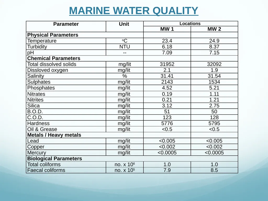
Reply: Marine Surface water samples were collected from two locations Nhavakhadi & Elephanta Jetty and were analysed for physicochemical and biological parameters. The pH, DO, BOD COD, Oil & Grease & Total Coliform are observed to be as per Primary Water Quality Criteria for Class SW-IV Waters (For Harbour Waters) of CPCB COMPLIANCE TO ADDITIONAL TERMS OF RREFERENCE<br>
Reply: Marine Surface water samples were collected from two locations Nhavakhadi & Elephanta Jetty and were analysed for physicochemical and biological parameters. The pH, DO, BOD COD, Oil & Grease & Total Coliform are observed to be as per Primary Water Quality Criteria for Class SW-IV Waters (For Harbour Waters) of CPCB COMPLIANCE TO ADDITIONAL TERMS OF RREFERENCE<br>
24
COMPLIANCE TO ADDITIONAL TERMS OF RREFERENCE<br>
25
Point 18: Details of Emission, effluents, solid waste and hazardous waste generation and their management in the existing and proposed facilities
Reply: No any effluent, solid waste and hazardous wast will be generated from this project. During dredging (construction) phase, suspended particulate matter is the main pollutant generated during the project activitity due to operation of DG sets, dredger, construction vessels and other construction equipments etc. The DG sets and barges used during the dredging activity will emit the pollutants by burning fuel (diesel)
Mitigation measures are as follows
1.A dredge material disposal option shall be in place
2.Adequate capacity shall be available at the disposal location for the quantity of the material to be removed, taking into account bulking factors and water content
3.All necessary environmental and planning approvals shall be in place in relation to dredge material disposal
4.Testing of dredged material shall be undertaken on regular basis COMPLIANCE TO ADDITIONAL TERMS OF RREFERENCE<br>
Reply: No any effluent, solid waste and hazardous wast will be generated from this project. During dredging (construction) phase, suspended particulate matter is the main pollutant generated during the project activitity due to operation of DG sets, dredger, construction vessels and other construction equipments etc. The DG sets and barges used during the dredging activity will emit the pollutants by burning fuel (diesel)
Mitigation measures are as follows
1.A dredge material disposal option shall be in place
2.Adequate capacity shall be available at the disposal location for the quantity of the material to be removed, taking into account bulking factors and water content
3.All necessary environmental and planning approvals shall be in place in relation to dredge material disposal
4.Testing of dredged material shall be undertaken on regular basis COMPLIANCE TO ADDITIONAL TERMS OF RREFERENCE<br>
26
5.Harbour Master shall be notify of dredging program, including timing, locations to be dredged, equipment to be used and any access restrictions or hazards to vessels using the navigation access channel.
6.Harbour Master shall be notify of completion of the dredging program
7.Fishermen shall be notify of proposed works
8.Proper signage shall be in place to notify Fishermen
9.It shall be ensure that the dredging equipment and associated vessels comply with all the necessary requirements
10.It shall be ensure that access to the project area limit is maintained throughout the dredging program.
11.Clearly delineate area to be dredged and review with dredging contractor. Provided written advice to dredging contractor on dredging area. COMPLIANCE TO ADDITIONAL TERMS OF RREFERENCE<br>
6.Harbour Master shall be notify of completion of the dredging program
7.Fishermen shall be notify of proposed works
8.Proper signage shall be in place to notify Fishermen
9.It shall be ensure that the dredging equipment and associated vessels comply with all the necessary requirements
10.It shall be ensure that access to the project area limit is maintained throughout the dredging program.
11.Clearly delineate area to be dredged and review with dredging contractor. Provided written advice to dredging contractor on dredging area. COMPLIANCE TO ADDITIONAL TERMS OF RREFERENCE<br>
27
Point 19: The EIA would also include an affidavit that no Hazardous chemicals as defined under the Environment Protection Act, 1986 are proposed to be handled
Reply: Noted COMPLIANCE TO ADDITIONAL TERMS OF RREFERENCE<br>
Reply: Noted COMPLIANCE TO ADDITIONAL TERMS OF RREFERENCE<br>
28
Point 20: Toxicity Factor to be carried out on treated trade effluent beside chemical analysis
Reply: No effluent is envisaged to be generated in proposed project activity COMPLIANCE TO ADDITIONAL TERMS OF RREFERENCE<br>
Reply: No effluent is envisaged to be generated in proposed project activity COMPLIANCE TO ADDITIONAL TERMS OF RREFERENCE<br>
29
Point 21: The existing project should avail of and submit consent to operate from the State Pollution Control Board
Reply: Copy of the Consent to Operate for Second Chemical Berth is attached as under COMPLIANCE TO ADDITIONAL TERMS OF RREFERENCE<br>
Reply: Copy of the Consent to Operate for Second Chemical Berth is attached as under COMPLIANCE TO ADDITIONAL TERMS OF RREFERENCE<br>
30
Point 22: Requirement of water, power, with source of supply, status of approval, water balance diagram, man-power requirement (regular and contract)
Reply: The proposed activity pertains to dredging acitivity for deepening & widening of Navigation Channel at Second Container Terminal, thus does not envisages water use COMPLIANCE TO ADDITIONAL TERMS OF RREFERENCE Point 23: Wastewater management plan.
Reply: No sewage envisages to generated for proposed project<br>
Reply: The proposed activity pertains to dredging acitivity for deepening & widening of Navigation Channel at Second Container Terminal, thus does not envisages water use COMPLIANCE TO ADDITIONAL TERMS OF RREFERENCE Point 23: Wastewater management plan.
Reply: No sewage envisages to generated for proposed project<br>
31
Point 24: Details of Environmental Monitoring Plan
Reply: Summary of Environmental Monitoring Programme is as under COMPLIANCE TO ADDITIONAL TERMS OF RREFERENCE<br>
Reply: Summary of Environmental Monitoring Programme is as under COMPLIANCE TO ADDITIONAL TERMS OF RREFERENCE<br>
32
Point 25: To prepare a detailed biodiversity impact assessment report and management plan through the NIOS or any other institute of repute on marine, brackish water and fresh water ecology and biodiversity. The report shall study the impact on the rivers, estuary and the sea and include the intertidal biotopes, corals and coral communities, molluscs, sea grasses, sea weeds, subtidal habitats, fishes, other marine and aquatic micro, macro and mega flora and fauna including benthos, plankton, turtles, birds etc. as also the productivity. The data collection and impact assessment shall be as per standard survey methods. This plan, duly evaluated and validated by the State Biodiversity Board shall form a part of the EIA report
Reply:
Marine Ecological Impact Assessment Studies was conducted in January 2018 by NIO for the Proposed Oil Berth (JD5) at Jawahar Dweep, Mumbai which is located adjacent to SCB was submitted to State Biodiversity Board on 21.02.2018 COMPLIANCE TO ADDITIONAL TERMS OF RREFERENCE<br>
Reply:
Marine Ecological Impact Assessment Studies was conducted in January 2018 by NIO for the Proposed Oil Berth (JD5) at Jawahar Dweep, Mumbai which is located adjacent to SCB was submitted to State Biodiversity Board on 21.02.2018 COMPLIANCE TO ADDITIONAL TERMS OF RREFERENCE<br>
33
Point 26: To prepare a detailed biodiversity impact assessment report and management plan through the NIOS or any other institute of repute on marine, brackish water and fresh water ecology and biodiversity. The report shall study the impact on the rivers, estuary and the sea and include the intertidal biotopes, corals and coral communities, molluscs, sea grasses, sea weeds, subtidal habitats, fishes, other marine and aquatic micro, macro and mega flora and fauna including benthos, plankton, turtles, birds etc. as also the productivity. The data collection and impact assessment shall be as per standard survey methods. This plan, duly evaluated and validated by the State Biodiversity Board shall form a part of the EIA report
Reply:
Marine Ecological Impact Assessment Studies was conducted in January 2018 by NIO for the Proposed Oil Berth (JD5) at Jawahar Dweep, Mumbai which is located adjacent to SCB was submitted to State Biodiversity Board on 21.02.2018 COMPLIANCE TO ADDITIONAL TERMS OF RREFERENCE<br>
Reply:
Marine Ecological Impact Assessment Studies was conducted in January 2018 by NIO for the Proposed Oil Berth (JD5) at Jawahar Dweep, Mumbai which is located adjacent to SCB was submitted to State Biodiversity Board on 21.02.2018 COMPLIANCE TO ADDITIONAL TERMS OF RREFERENCE<br>
34
Point 27: A detailed traffic management and traffic decongestion plan to ensure that the current level of service of the roads within a 05 kms radius of the project is maintained and improved upon after the implementation of the project. This plan should be based on cumulative impact of all development and increased habitation being carried out or proposed to be carried out by the project or other agencies in this 05 Kms radius of the site in different scenarios of space and time and the traffic management plan shall be duly validated and certified by the State Urban Development department and the P.W.D. and shall also have their consent to the implementation of components of the plan which involve the participation of these departments.
Reply:
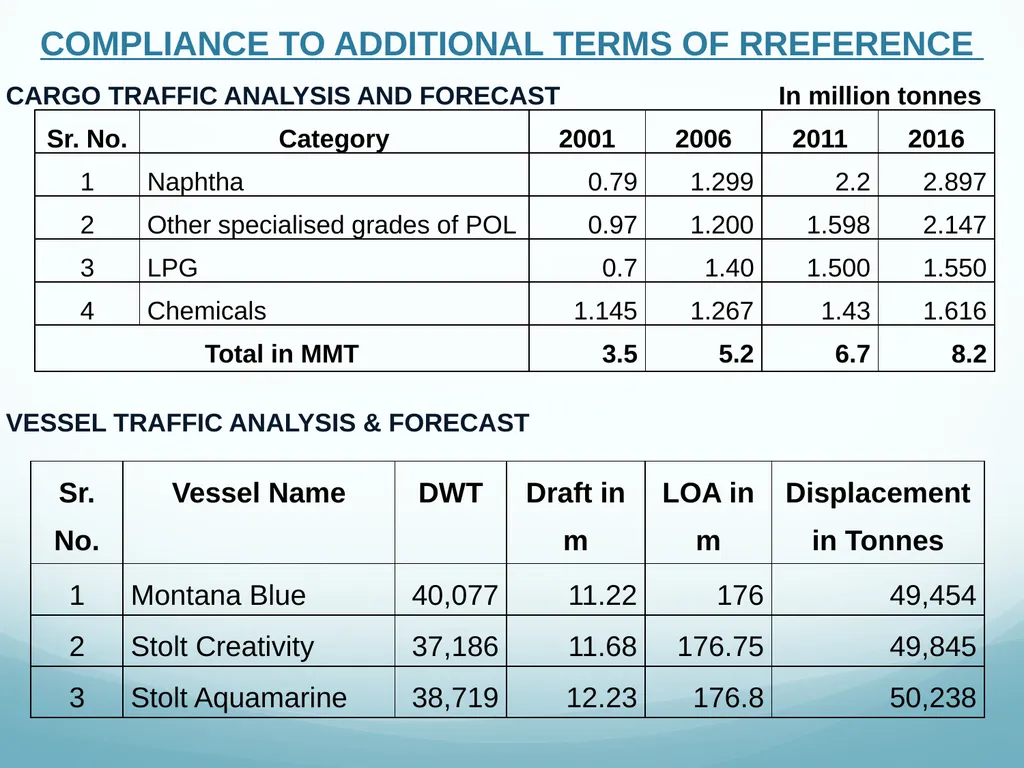
Details of Cargo Traffic Analysis and Forecast are given as under COMPLIANCE TO ADDITIONAL TERMS OF RREFERENCE<br>
Reply:
Details of Cargo Traffic Analysis and Forecast are given as under COMPLIANCE TO ADDITIONAL TERMS OF RREFERENCE<br>
35
CARGO TRAFFIC ANALYSIS AND FORECAST In million tonnes VESSEL TRAFFIC ANALYSIS & FORECAST COMPLIANCE TO ADDITIONAL TERMS OF RREFERENCE<br>
36
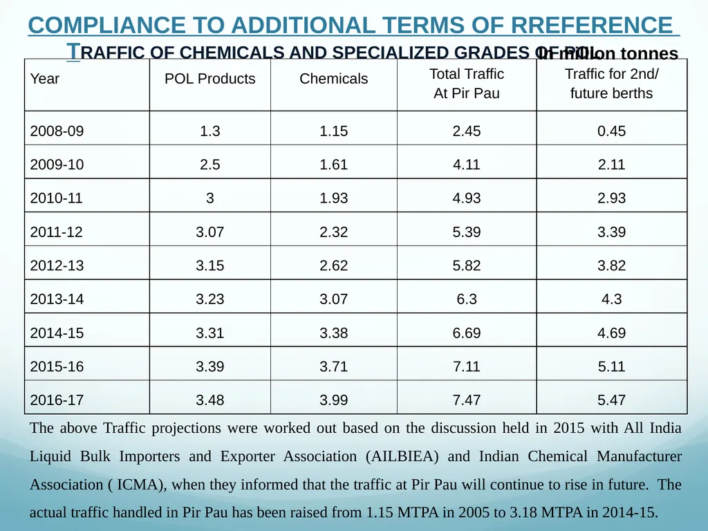
TRAFFIC OF CHEMICALS AND SPECIALIZED GRADES OF POL In million tonnes The above Traffic projections were worked out based on the discussion held in 2015 with All India Liquid Bulk Importers and Exporter Association (AILBIEA) and Indian Chemical Manufacturer Association ( ICMA), when they informed that the traffic at Pir Pau will continue to rise in future. The actual traffic handled in Pir Pau has been raised from 1.15 MTPA in 2005 to 3.18 MTPA in 2014-15. COMPLIANCE TO ADDITIONAL TERMS OF RREFERENCE<br>
37
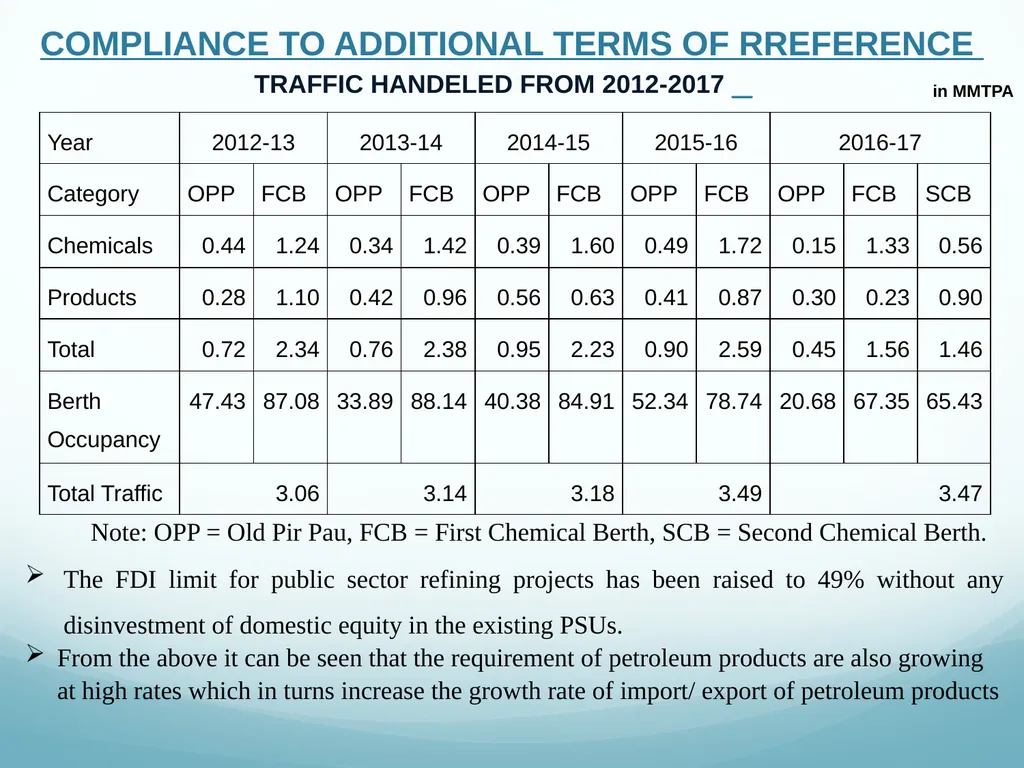
TRAFFIC HANDELED FROM 2012-2017 _ in MMTPA Note: OPP = Old Pir Pau, FCB = First Chemical Berth, SCB = Second Chemical Berth. The FDI limit for public sector refining projects has been raised to 49% without any disinvestment of domestic equity in the existing PSUs.
From the above it can be seen that the requirement of petroleum products are also growing at high rates which in turns increase the growth rate of import/ export of petroleum products COMPLIANCE TO ADDITIONAL TERMS OF RREFERENCE<br>
From the above it can be seen that the requirement of petroleum products are also growing at high rates which in turns increase the growth rate of import/ export of petroleum products COMPLIANCE TO ADDITIONAL TERMS OF RREFERENCE<br>
38
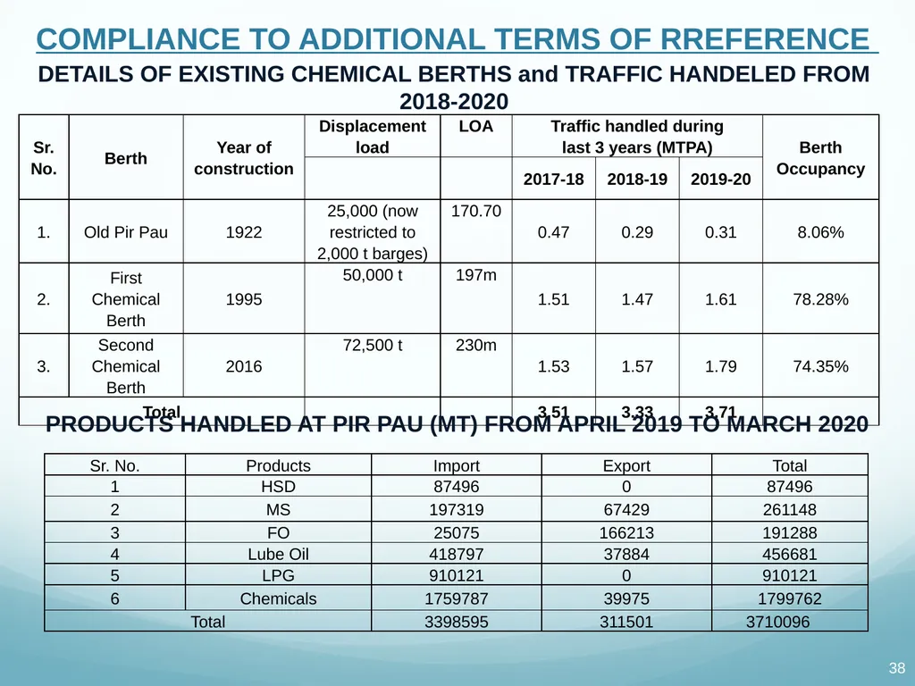
DETAILS OF EXISTING CHEMICAL BERTHS and TRAFFIC HANDELED FROM 2018-2020 PRODUCTS HANDLED AT PIR PAU (MT) FROM APRIL 2019 TO MARCH 2020 COMPLIANCE TO ADDITIONAL TERMS OF RREFERENCE<br>
39
Point 28: Disaster Management Plan for the above terminal.
Reply: Risk assessment and disaster management plan as under COMPLIANCE TO ADDITIONAL TERMS OF RREFERENCE Risks involved are due to:
Fire on Tankers (vessels)
Spillage form tankers
Spillage from pipeline
Spillage due to collision in channel/jetty accidents
Spillage while bunkering by vessel
Air strike / war situation
Cyclone / rough weather at sea
This would, depending upon the type and intensity, involve disasters in terms of loss of life and damage to the tower. Therefore to avoid and minimise this, disaster and emergency management plays a very important role.<br>
Reply: Risk assessment and disaster management plan as under COMPLIANCE TO ADDITIONAL TERMS OF RREFERENCE Risks involved are due to:
Fire on Tankers (vessels)
Spillage form tankers
Spillage from pipeline
Spillage due to collision in channel/jetty accidents
Spillage while bunkering by vessel
Air strike / war situation
Cyclone / rough weather at sea
This would, depending upon the type and intensity, involve disasters in terms of loss of life and damage to the tower. Therefore to avoid and minimise this, disaster and emergency management plays a very important role.<br>
40
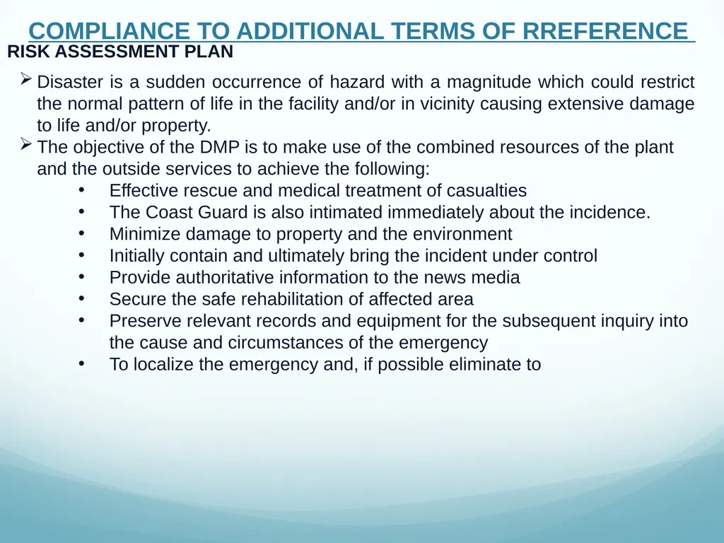
RISK ASSESSMENT PLAN Disaster is a sudden occurrence of hazard with a magnitude which could restrict the normal pattern of life in the facility and/or in vicinity causing extensive damage to life and/or property.
The objective of the DMP is to make use of the combined resources of the plant and the outside services to achieve the following:
Effective rescue and medical treatment of casualties
The Coast Guard is also intimated immediately about the incidence.
Minimize damage to property and the environment
Initially contain and ultimately bring the incident under control
Provide authoritative information to the news media
Secure the safe rehabilitation of affected area
Preserve relevant records and equipment for the subsequent inquiry into the cause and circumstances of the emergency
To localize the emergency and, if possible eliminate to COMPLIANCE TO ADDITIONAL TERMS OF RREFERENCE<br>
The objective of the DMP is to make use of the combined resources of the plant and the outside services to achieve the following:
Effective rescue and medical treatment of casualties
The Coast Guard is also intimated immediately about the incidence.
Minimize damage to property and the environment
Initially contain and ultimately bring the incident under control
Provide authoritative information to the news media
Secure the safe rehabilitation of affected area
Preserve relevant records and equipment for the subsequent inquiry into the cause and circumstances of the emergency
To localize the emergency and, if possible eliminate to COMPLIANCE TO ADDITIONAL TERMS OF RREFERENCE<br>
41
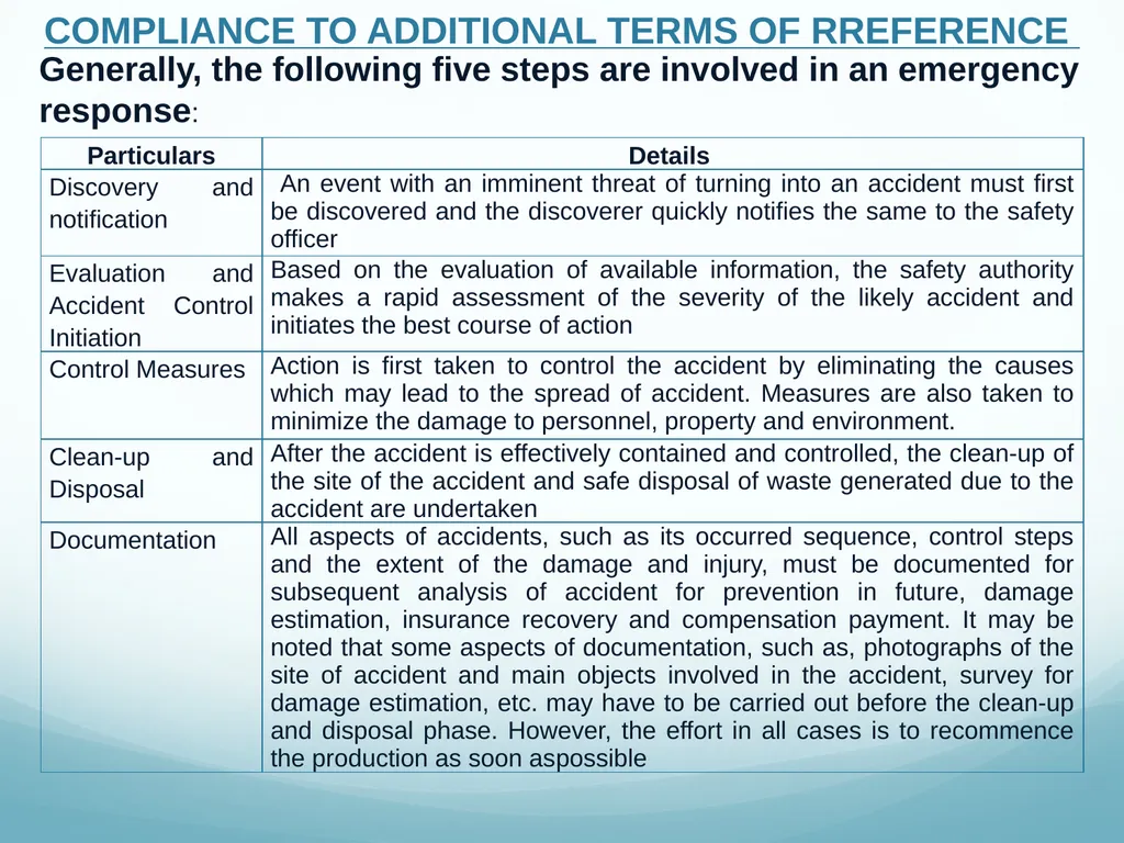
Generally, the following five steps are involved in an emergency response: COMPLIANCE TO ADDITIONAL TERMS OF RREFERENCE<br>
42
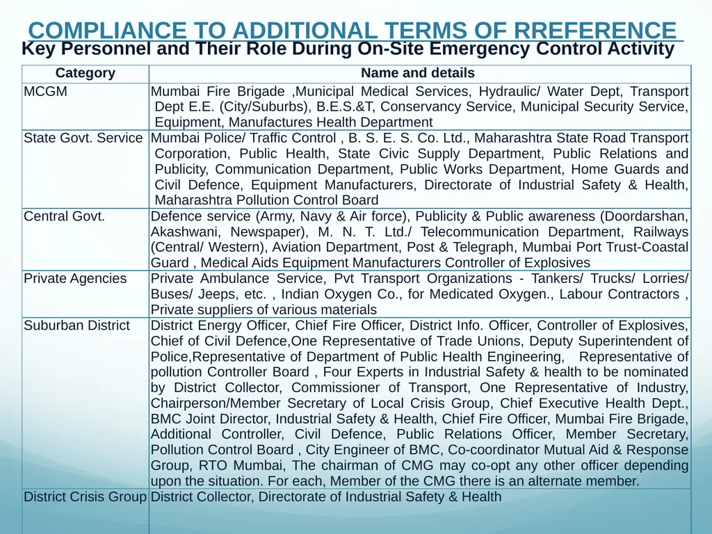
Key Personnel and Their Role During On-Site Emergency Control Activity COMPLIANCE TO ADDITIONAL TERMS OF RREFERENCE<br>
43
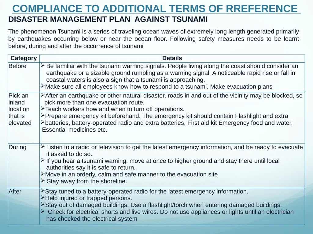
DISASTER MANAGEMENT PLAN AGAINST TSUNAMI The phenomenon Tsunami is a series of traveling ocean waves of extremely long length generated primarily by earthquakes occurring below or near the ocean floor. Following safety measures needs to be learnt before, during and after the occurrence of tsunami COMPLIANCE TO ADDITIONAL TERMS OF RREFERENCE<br>
44
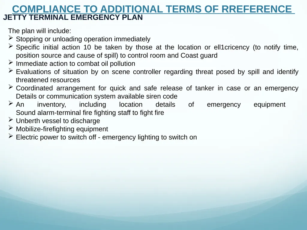
JETTY TERMINAL EMERGENCY PLAN The plan will include:
Stopping or unloading operation immediately
Specific initial action 10 be taken by those at the location or ell1cricency (to notify time, position source and cause of spill) to control room and Coast guard
Immediate action to combat oil pollution
Evaluations of situation by on scene controller regarding threat posed by spill and identify threatened resources
Coordinated arrangement for quick and safe release of tanker in case or an emergency Details or communication system available siren code
An inventory, including location details of emergency equipment Sound alarm-terminal fire fighting staff to fight fire
Unberth vessel to discharge
Mobilize-firefighting equipment
Electric power to switch off - emergency lighting to switch on COMPLIANCE TO ADDITIONAL TERMS OF RREFERENCE<br>
Stopping or unloading operation immediately
Specific initial action 10 be taken by those at the location or ell1cricency (to notify time, position source and cause of spill) to control room and Coast guard
Immediate action to combat oil pollution
Evaluations of situation by on scene controller regarding threat posed by spill and identify threatened resources
Coordinated arrangement for quick and safe release of tanker in case or an emergency Details or communication system available siren code
An inventory, including location details of emergency equipment Sound alarm-terminal fire fighting staff to fight fire
Unberth vessel to discharge
Mobilize-firefighting equipment
Electric power to switch off - emergency lighting to switch on COMPLIANCE TO ADDITIONAL TERMS OF RREFERENCE<br>
45
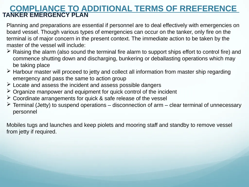
TANKER EMERGENCY PLAN Planning and preparations are essential if personnel are to deal effectively with emergencies on board vessel. Though various types of emergencies can occur on the tanker, only fire on the terminal is of major concern in the present context. The immediate action to be taken by the master of the vessel will include:
Raising the alarm (also sound the terminal fire alarm to support ships effort to control fire) and commence shutting down and discharging, bunkering or deballasting operations which may be taking place
Harbour master will proceed to jetty and collect all information from master ship regarding emergency and pass the same to action group
Locate and assess the incident and assess possible dangers
Organize manpower and equipment for quick control of the incident
Coordinate arrangements for quick & safe release of the vessel
Terminal (Jetty) to suspend operations – disconnection of arm – clear terminal of unnecessary personnel
Mobiles tugs and launches and keep piolets and mooring staff and standby to remove vessel from jetty if required. COMPLIANCE TO ADDITIONAL TERMS OF RREFERENCE<br>
Raising the alarm (also sound the terminal fire alarm to support ships effort to control fire) and commence shutting down and discharging, bunkering or deballasting operations which may be taking place
Harbour master will proceed to jetty and collect all information from master ship regarding emergency and pass the same to action group
Locate and assess the incident and assess possible dangers
Organize manpower and equipment for quick control of the incident
Coordinate arrangements for quick & safe release of the vessel
Terminal (Jetty) to suspend operations – disconnection of arm – clear terminal of unnecessary personnel
Mobiles tugs and launches and keep piolets and mooring staff and standby to remove vessel from jetty if required. COMPLIANCE TO ADDITIONAL TERMS OF RREFERENCE<br>
46
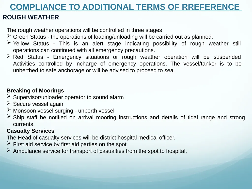
ROUGH WEATHER The rough weather operations will be controlled in three stages
Green Status - the operations of loading/unloading will be carried out as planned.
Yellow Status - This is an alert stage indicating possibility of rough weather still operations can continued with all emergency precautions.
Red Status - Emergency situations or rough weather operation will be suspended Activities controlled by incharge of emergency operations. The vessel/tanker is to be unberthed to safe anchorage or will be advised to proceed to sea.
Breaking of Moorings
Supervisor/unloader operator to sound alarm
Secure vessel again
Monsoon vessel surging - unberth vessel
Ship staff be notified on arrival mooring instructions and details of tidal range and strong currents.
Casualty Services
The Head of casualty services will be district hospital medical officer.
First aid service by first aid parties on the spot
Ambulance service for transport of casualties from the spot to hospital. COMPLIANCE TO ADDITIONAL TERMS OF RREFERENCE<br>
Green Status - the operations of loading/unloading will be carried out as planned.
Yellow Status - This is an alert stage indicating possibility of rough weather still operations can continued with all emergency precautions.
Red Status - Emergency situations or rough weather operation will be suspended Activities controlled by incharge of emergency operations. The vessel/tanker is to be unberthed to safe anchorage or will be advised to proceed to sea.
Breaking of Moorings
Supervisor/unloader operator to sound alarm
Secure vessel again
Monsoon vessel surging - unberth vessel
Ship staff be notified on arrival mooring instructions and details of tidal range and strong currents.
Casualty Services
The Head of casualty services will be district hospital medical officer.
First aid service by first aid parties on the spot
Ambulance service for transport of casualties from the spot to hospital. COMPLIANCE TO ADDITIONAL TERMS OF RREFERENCE<br>
47
DISASTER MANAGEMENT PLAN AGAINST CYCLONE The A cyclone is a storm accompanied by high speed whistling and howling winds. It brings torrential rains. A cyclonic storm develops over tropical oceans like the Indian Ocean and Bay of Bengal and the Arabian Sea. Its strong winds blow at great speed, which can be more than 118 km/hr. When a cyclonic storm approaches, the skies begin to darken accompanied by lightning and thunder and a continuous downpour of rain Safety activity to be performed before and during cyclone
Create storm awareness by discussing effects of a cyclonic storm with members so that everyone knows what one can and should do in an emergency. This helps to remove fear and anxiety and prepares everyone to respond to emergencies quickly.
Keep your valuables and documents in containers, which cannot be damaged by water.
Keep lanterns, torches and spare batteries ready. These must be kept in secure places and handy.
Make plans for people who are either sick, suffer from disabilities, aged and children.
Keep trees and shrubs trimmed. Remove damaged and decayed parts of trees to make them resist wind and reduce the potential for damage. Cut weak branches and make winds blow through.
Continue to listen to warning bulletins and keep in touch with local officials. Keep radio sets in
working condition. Battery powered radio sets are desirable.
Evacuate people to places of safety when advised COMPLIANCE TO ADDITIONAL TERMS OF RREFERENCE<br>
Create storm awareness by discussing effects of a cyclonic storm with members so that everyone knows what one can and should do in an emergency. This helps to remove fear and anxiety and prepares everyone to respond to emergencies quickly.
Keep your valuables and documents in containers, which cannot be damaged by water.
Keep lanterns, torches and spare batteries ready. These must be kept in secure places and handy.
Make plans for people who are either sick, suffer from disabilities, aged and children.
Keep trees and shrubs trimmed. Remove damaged and decayed parts of trees to make them resist wind and reduce the potential for damage. Cut weak branches and make winds blow through.
Continue to listen to warning bulletins and keep in touch with local officials. Keep radio sets in
working condition. Battery powered radio sets are desirable.
Evacuate people to places of safety when advised COMPLIANCE TO ADDITIONAL TERMS OF RREFERENCE<br>
48
DISASTER MANAGEMENT PLAN AGAINST CYCLONE Activities which should not be done during cyclone
During the storm do not venture out unless advised to evacuate.
If you have a vehicle and wish to move out, leave early before the onset of a cyclone.
Avoid remaining on the top floor of dwellings. Stay close to the ground.
Avoid taking shelters near damaged buildings or near trees.
Do not touch power lines. One may get electrocuted. Activities which are recommended to do after storm/Cyclone
Watch out for broken glass and other sharp items in debris.
Watch out for snakes and insects. Try to call for help.
Listen to the advice of local officials and emergency workers.
Be sure that the storm has subsided before venturing out. It is advisable to wait for the "all clear message" on radio and TV networks.
Wait for emergency relief teams to arrive. It may take a little time before relief becomes effective.
Stay away from flooded areas COMPLIANCE TO ADDITIONAL TERMS OF RREFERENCE<br>
During the storm do not venture out unless advised to evacuate.
If you have a vehicle and wish to move out, leave early before the onset of a cyclone.
Avoid remaining on the top floor of dwellings. Stay close to the ground.
Avoid taking shelters near damaged buildings or near trees.
Do not touch power lines. One may get electrocuted. Activities which are recommended to do after storm/Cyclone
Watch out for broken glass and other sharp items in debris.
Watch out for snakes and insects. Try to call for help.
Listen to the advice of local officials and emergency workers.
Be sure that the storm has subsided before venturing out. It is advisable to wait for the "all clear message" on radio and TV networks.
Wait for emergency relief teams to arrive. It may take a little time before relief becomes effective.
Stay away from flooded areas COMPLIANCE TO ADDITIONAL TERMS OF RREFERENCE<br>
49
DISASTER MANAGEMENT PLAN AGAINST EARTHQUAKE General Information about the Earthquake
Take the training for first aid and fire fighting
Do not keep heavy and fragile things in the selves
Do don’t hang photo frames, mirrors, or glasses above your desk activity in case of an Earthquake
Do not panic
If already inside, then Stay indoors. Get under a heavy desk or table and hang on to it.
If fire breaks out, drop on the floor and crawl towards the exist
If you are out doors during the quake, keep away from buildings, trees and electricity lines. Walk towards open places, in a calm and composed manner.
If you are driving, quickly but carefully move your car to clear area. Stay inside the car until shaking stops Earthquake is another natural disaster which can make a larger Impact on human beings and as well as on other livings and non-livings. Strategy can be prepared to reduce the possible impact of the earthquake and it can be briefly described as per following points COMPLIANCE TO ADDITIONAL TERMS OF RREFERENCE<br>
Take the training for first aid and fire fighting
Do not keep heavy and fragile things in the selves
Do don’t hang photo frames, mirrors, or glasses above your desk activity in case of an Earthquake
Do not panic
If already inside, then Stay indoors. Get under a heavy desk or table and hang on to it.
If fire breaks out, drop on the floor and crawl towards the exist
If you are out doors during the quake, keep away from buildings, trees and electricity lines. Walk towards open places, in a calm and composed manner.
If you are driving, quickly but carefully move your car to clear area. Stay inside the car until shaking stops Earthquake is another natural disaster which can make a larger Impact on human beings and as well as on other livings and non-livings. Strategy can be prepared to reduce the possible impact of the earthquake and it can be briefly described as per following points COMPLIANCE TO ADDITIONAL TERMS OF RREFERENCE<br>
50
DISASTER MANAGEMENT PLAN AGAINST EARTHQUAKE Recommended activity after Earthquake
Listen to radio-TV and other media for Government Announcement
Check for injuries to yourself and those around you. Take first aid where you can
Extinguish fire, if any
Examine walls, floors, doors, staircases and windows to make sure that the building is not in danger of collapsing
Do not enter into the unsafe or risky buildings
Inspect for Gas leaks-If you smell gas or hear blowing or hissing noises, open a window and quickly leave the building. Don’t light your kitchen stove if you suspect a gas leak.
Switch off electric lines COMPLIANCE TO ADDITIONAL TERMS OF RREFERENCE<br>
Listen to radio-TV and other media for Government Announcement
Check for injuries to yourself and those around you. Take first aid where you can
Extinguish fire, if any
Examine walls, floors, doors, staircases and windows to make sure that the building is not in danger of collapsing
Do not enter into the unsafe or risky buildings
Inspect for Gas leaks-If you smell gas or hear blowing or hissing noises, open a window and quickly leave the building. Don’t light your kitchen stove if you suspect a gas leak.
Switch off electric lines COMPLIANCE TO ADDITIONAL TERMS OF RREFERENCE<br>
51
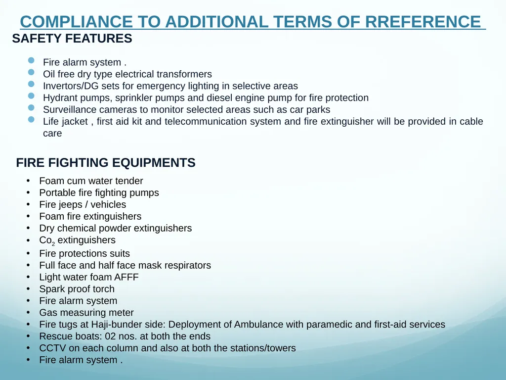
Fire alarm system .
Oil free dry type electrical transformers
Invertors/DG sets for emergency lighting in selective areas
Hydrant pumps, sprinkler pumps and diesel engine pump for fire protection
Surveillance cameras to monitor selected areas such as car parks
Life jacket , first aid kit and telecommunication system and fire extinguisher will be provided in cable care SAFETY FEATURES FIRE FIGHTING EQUIPMENTS Foam cum water tender
Portable fire fighting pumps
Fire jeeps / vehicles
Foam fire extinguishers
Dry chemical powder extinguishers
Co2 extinguishers
Fire protections suits
Full face and half face mask respirators
Light water foam AFFF
Spark proof torch
Fire alarm system
Gas measuring meter
Fire tugs at Haji-bunder side: Deployment of Ambulance with paramedic and first-aid services
Rescue boats: 02 nos. at both the ends
CCTV on each column and also at both the stations/towers
Fire alarm system . COMPLIANCE TO ADDITIONAL TERMS OF RREFERENCE<br>
Oil free dry type electrical transformers
Invertors/DG sets for emergency lighting in selective areas
Hydrant pumps, sprinkler pumps and diesel engine pump for fire protection
Surveillance cameras to monitor selected areas such as car parks
Life jacket , first aid kit and telecommunication system and fire extinguisher will be provided in cable care SAFETY FEATURES FIRE FIGHTING EQUIPMENTS Foam cum water tender
Portable fire fighting pumps
Fire jeeps / vehicles
Foam fire extinguishers
Dry chemical powder extinguishers
Co2 extinguishers
Fire protections suits
Full face and half face mask respirators
Light water foam AFFF
Spark proof torch
Fire alarm system
Gas measuring meter
Fire tugs at Haji-bunder side: Deployment of Ambulance with paramedic and first-aid services
Rescue boats: 02 nos. at both the ends
CCTV on each column and also at both the stations/towers
Fire alarm system . COMPLIANCE TO ADDITIONAL TERMS OF RREFERENCE<br>
52
Point 28: Layout plan of existing and proposed Greenbelt
Reply: The proposed activity pertains to dredging acitivity for deepening & widening of Navigation Channel at Second Container Terminal, thus does not envisages greenbelt COMPLIANCE TO ADDITIONAL TERMS OF RREFERENCE Point 29: A response to any complaints that have been received by the project against the setting up of the project including the representation submitted by the Conservation Action Trust
Reply: Not Applicable Point 30: The details of waste water disposal into the sea, its impacts and Management plan.
Reply: No sewage envisages to generated for proposed project<br>
Reply: The proposed activity pertains to dredging acitivity for deepening & widening of Navigation Channel at Second Container Terminal, thus does not envisages greenbelt COMPLIANCE TO ADDITIONAL TERMS OF RREFERENCE Point 29: A response to any complaints that have been received by the project against the setting up of the project including the representation submitted by the Conservation Action Trust
Reply: Not Applicable Point 30: The details of waste water disposal into the sea, its impacts and Management plan.
Reply: No sewage envisages to generated for proposed project<br>
53
Point 31: Status of court case pending against the project..
Reply: No any court case pending against the project COMPLIANCE TO ADDITIONAL TERMS OF RREFERENCE Point 32: Public hearing to be conducted and issues raised and commitments made by the project proponent on the same should be included in the EIA/EMP in the form of tabular chart with financial commitments budget for complying commitments made
Reply: Public hearing has been conducted (on 01.12.2020) as per guidelines and details of the the Public hearing is as under<br>
Reply: No any court case pending against the project COMPLIANCE TO ADDITIONAL TERMS OF RREFERENCE Point 32: Public hearing to be conducted and issues raised and commitments made by the project proponent on the same should be included in the EIA/EMP in the form of tabular chart with financial commitments budget for complying commitments made
Reply: Public hearing has been conducted (on 01.12.2020) as per guidelines and details of the the Public hearing is as under<br>
54
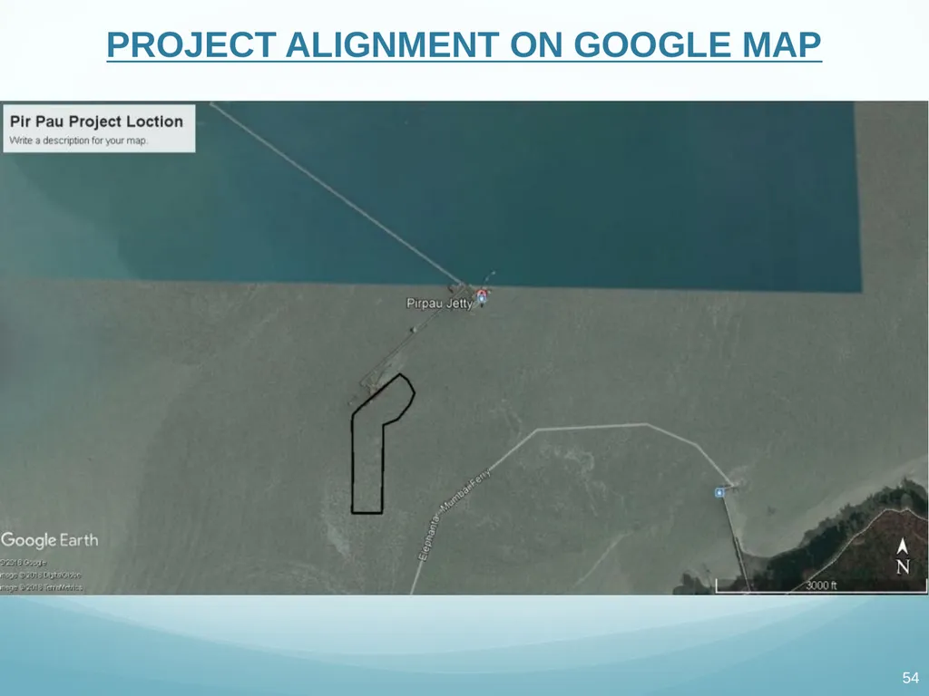
PROJECT ALIGNMENT ON GOOGLE MAP<br>
55
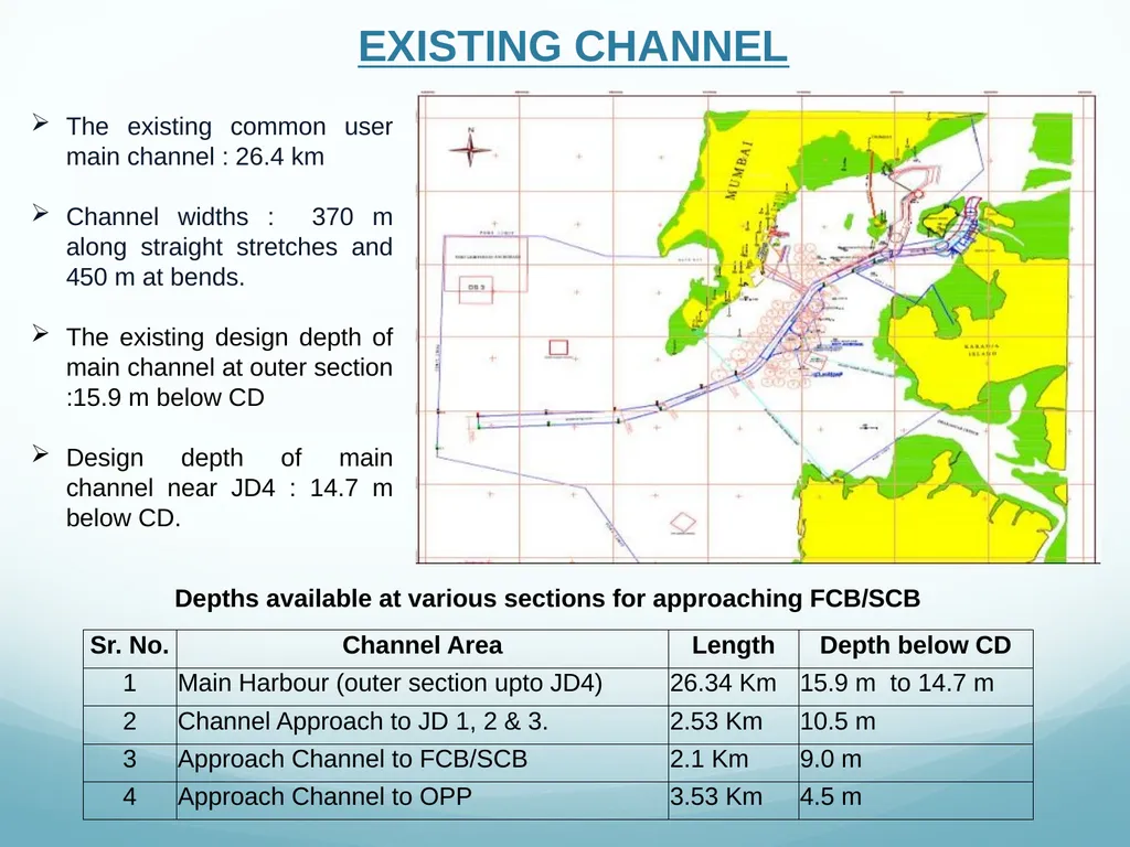
EXISTING CHANNEL The existing common user main channel : 26.4 km
Channel widths : 370 m along straight stretches and 450 m at bends.
The existing design depth of main channel at outer section :15.9 m below CD
Design depth of main channel near JD4 : 14.7 m below CD. Depths available at various sections for approaching FCB/SCB<br>
Channel widths : 370 m along straight stretches and 450 m at bends.
The existing design depth of main channel at outer section :15.9 m below CD
Design depth of main channel near JD4 : 14.7 m below CD. Depths available at various sections for approaching FCB/SCB<br>
56
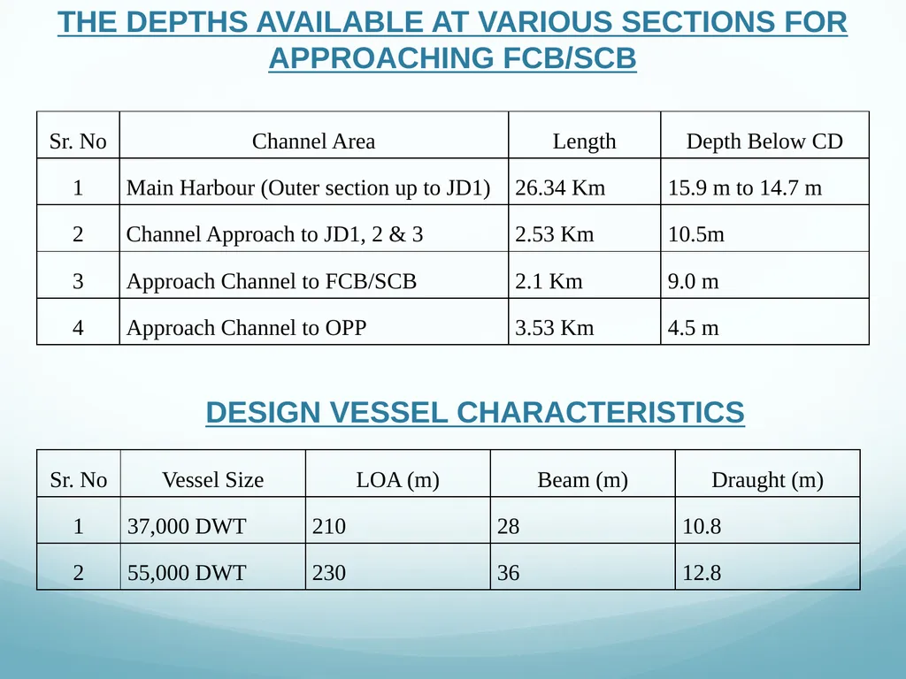
THE DEPTHS AVAILABLE AT VARIOUS SECTIONS FOR APPROACHING FCB/SCB DESIGN VESSEL CHARACTERISTICS<br>
57
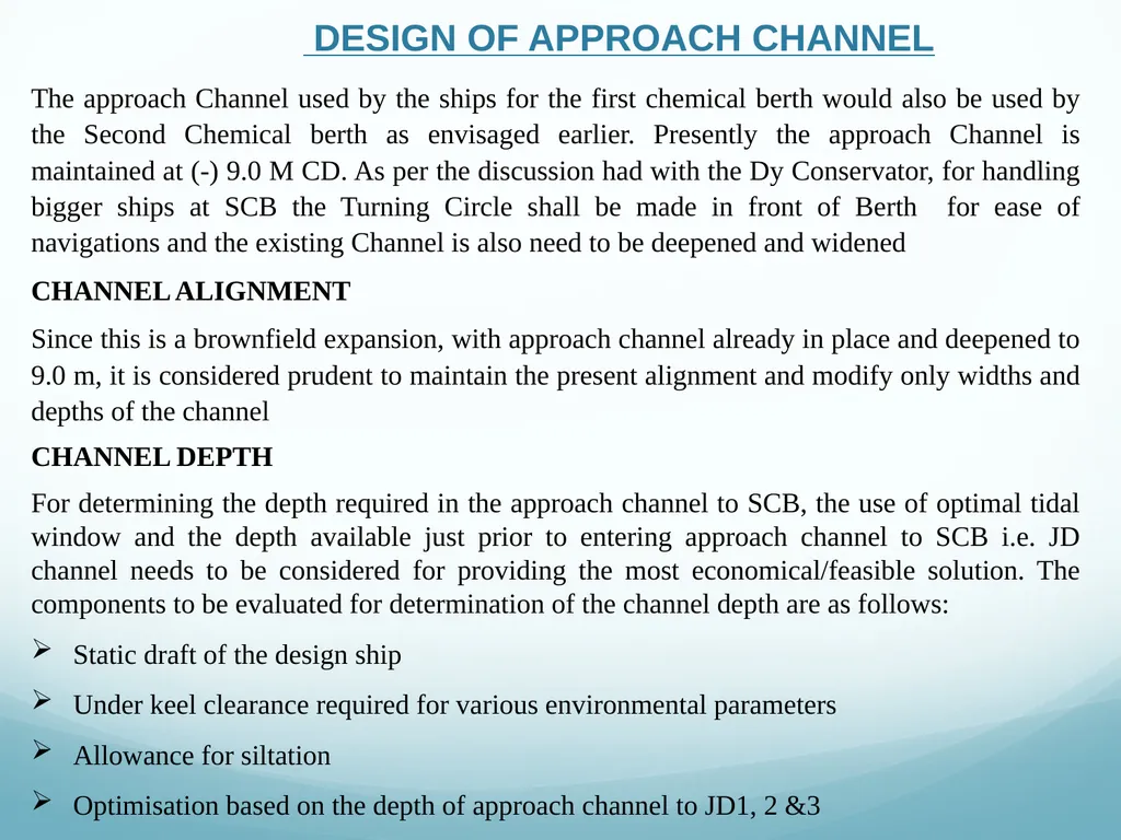
DESIGN OF APPROACH CHANNEL The approach Channel used by the ships for the first chemical berth would also be used by the Second Chemical berth as envisaged earlier. Presently the approach Channel is maintained at (-) 9.0 M CD. As per the discussion had with the Dy Conservator, for handling bigger ships at SCB the Turning Circle shall be made in front of Berth for ease of navigations and the existing Channel is also need to be deepened and widened
CHANNEL ALIGNMENT
Since this is a brownfield expansion, with approach channel already in place and deepened to 9.0 m, it is considered prudent to maintain the present alignment and modify only widths and depths of the channel
CHANNEL DEPTH
For determining the depth required in the approach channel to SCB, the use of optimal tidal window and the depth available just prior to entering approach channel to SCB i.e. JD channel needs to be considered for providing the most economical/feasible solution. The components to be evaluated for determination of the channel depth are as follows:
Static draft of the design ship
Under keel clearance required for various environmental parameters
Allowance for siltation
Optimisation based on the depth of approach channel to JD1, 2 &3<br>
CHANNEL ALIGNMENT
Since this is a brownfield expansion, with approach channel already in place and deepened to 9.0 m, it is considered prudent to maintain the present alignment and modify only widths and depths of the channel
CHANNEL DEPTH
For determining the depth required in the approach channel to SCB, the use of optimal tidal window and the depth available just prior to entering approach channel to SCB i.e. JD channel needs to be considered for providing the most economical/feasible solution. The components to be evaluated for determination of the channel depth are as follows:
Static draft of the design ship
Under keel clearance required for various environmental parameters
Allowance for siltation
Optimisation based on the depth of approach channel to JD1, 2 &3<br>
58
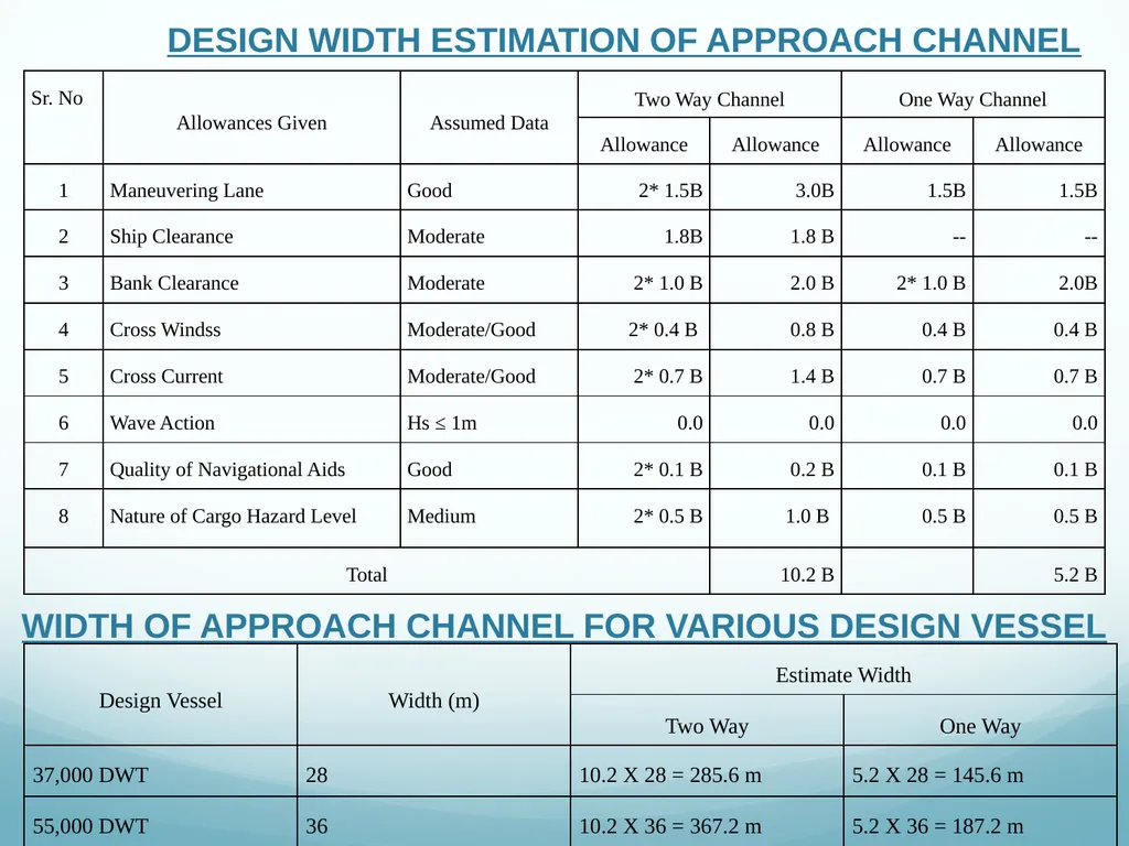
DESIGN WIDTH ESTIMATION OF APPROACH CHANNEL WIDTH OF APPROACH CHANNEL FOR VARIOUS DESIGN VESSEL<br>
59
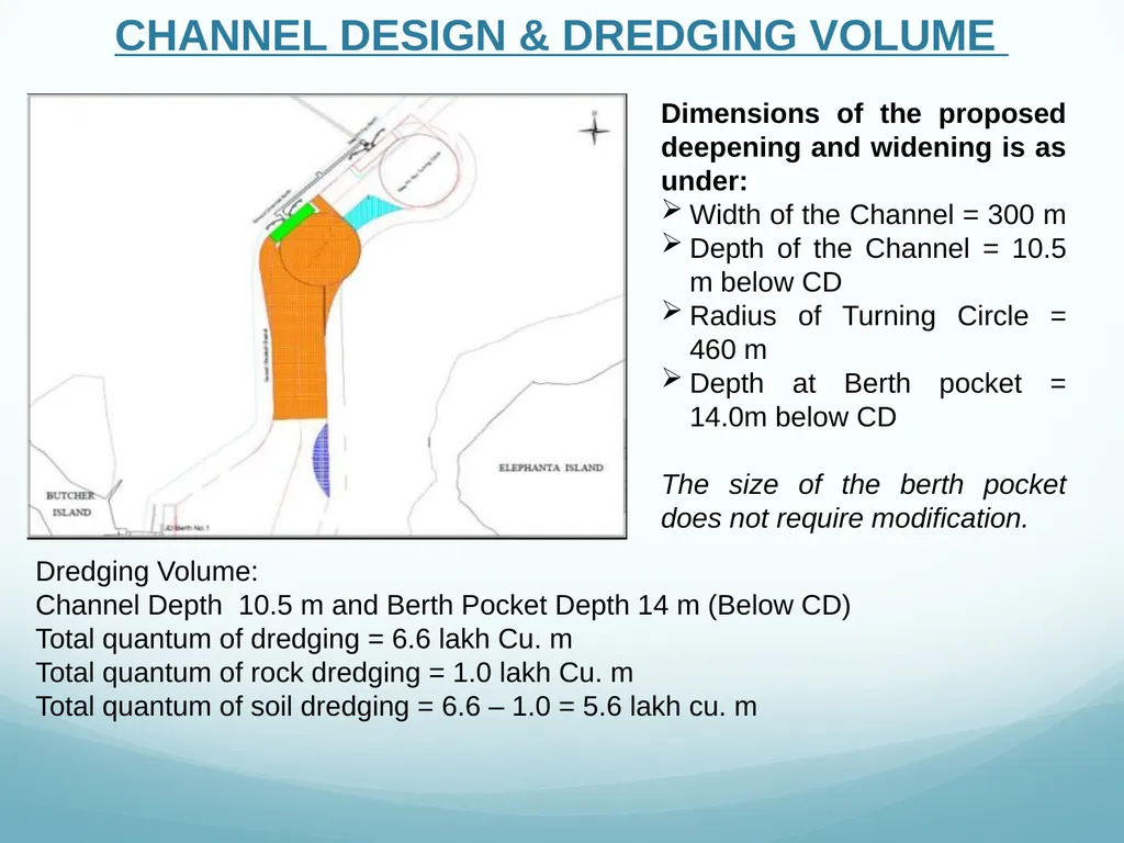
CHANNEL DESIGN & DREDGING VOLUME Dimensions of the proposed deepening and widening is as under:
Width of the Channel = 300 m
Depth of the Channel = 10.5 m below CD
Radius of Turning Circle = 460 m
Depth at Berth pocket = 14.0m below CD
The size of the berth pocket does not require modification. Dredging Volume:
Channel Depth 10.5 m and Berth Pocket Depth 14 m (Below CD)
Total quantum of dredging = 6.6 lakh Cu. m
Total quantum of rock dredging = 1.0 lakh Cu. m
Total quantum of soil dredging = 6.6 – 1.0 = 5.6 lakh cu. m<br>
Width of the Channel = 300 m
Depth of the Channel = 10.5 m below CD
Radius of Turning Circle = 460 m
Depth at Berth pocket = 14.0m below CD
The size of the berth pocket does not require modification. Dredging Volume:
Channel Depth 10.5 m and Berth Pocket Depth 14 m (Below CD)
Total quantum of dredging = 6.6 lakh Cu. m
Total quantum of rock dredging = 1.0 lakh Cu. m
Total quantum of soil dredging = 6.6 – 1.0 = 5.6 lakh cu. m<br>
60
DREDGING PROCESS The dredging process consists of following three elements:
Dredging: the process of removal of sediments and/or from the bed of the water body.
Transport of excavated material: transporting materials from the dredging area to the DS 3 site which is suggested by CWPRS.
Selection of Dredging Equipment
The most suitable types of dredgers to complete the dredging work of this nature in shortest possible time is Trailing Suction Hopper Dredger (TSHD) and Cutter Section Dredger (CSD). From the available bore hole data at berth pocket it can be seen that nature of strata is weathered rock which can be dredged with powerful cutter suction dredger. If the rock is sound/hard, it may not be economical to dredge with CSD.<br>
Dredging: the process of removal of sediments and/or from the bed of the water body.
Transport of excavated material: transporting materials from the dredging area to the DS 3 site which is suggested by CWPRS.
Selection of Dredging Equipment
The most suitable types of dredgers to complete the dredging work of this nature in shortest possible time is Trailing Suction Hopper Dredger (TSHD) and Cutter Section Dredger (CSD). From the available bore hole data at berth pocket it can be seen that nature of strata is weathered rock which can be dredged with powerful cutter suction dredger. If the rock is sound/hard, it may not be economical to dredge with CSD.<br>
61
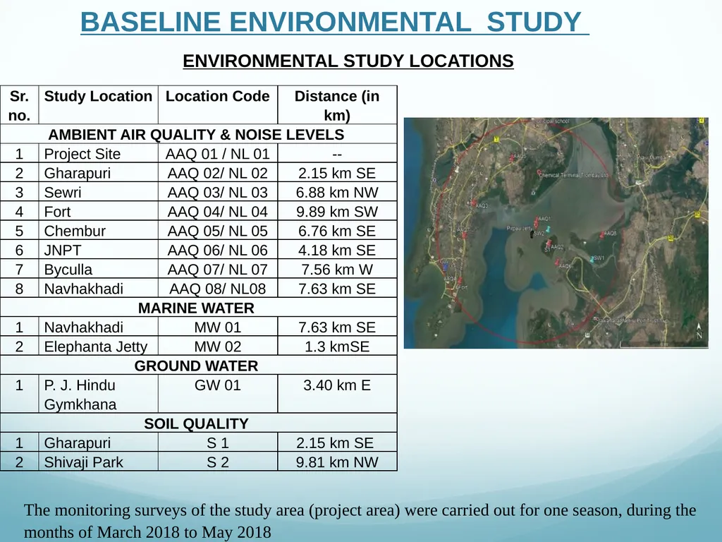
ENVIRONMENTAL STUDY LOCATIONS BASELINE ENVIRONMENTAL STUDY The monitoring surveys of the study area (project area) were carried out for one season, during the months of March 2018 to May 2018<br>
62
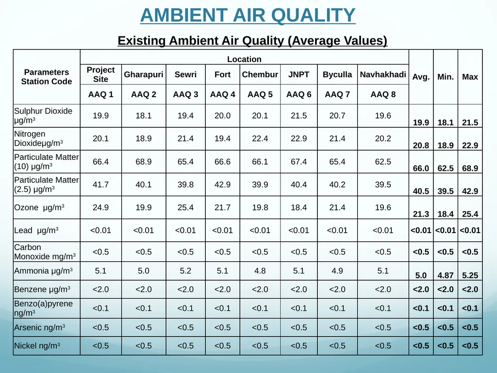
AMBIENT AIR QUALITY Existing Ambient Air Quality (Average Values)<br>
63
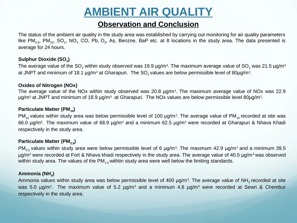
AMBIENT AIR QUALITY Observation and Conclusion The status of the ambient air quality in the study area was established by carrying out monitoring for air quality parameters like PM2.5, PM10, SO2, NOX, CO, Pb, O3, As, Benzne, BaP etc. at 8 locations in the study area. The data presented is average for 24 hours.
Sulphur Dioxide (SO2)
The average value of the SO2 within study observed was 19.9 µg/m3. The maximum average value of SO2 was 21.5 µg/m3 at JNPT and minimum of 18.1 µg/m3 at Gharapuri. The SO2 values are below permissible level of 80µg/m3.
Oxides of Nitrogen (NOx)
The average value of the NOx within study observed was 20.8 µg/m3. The maximum average value of NOx was 22.9 µg/m3 at JNPT and minimum of 18.9 µg/m3 at Gharapuri. The NOx values are below permissible level 80µg/m3.
Particulate Matter (PM10)
PM10 values within study area was below permissible level of 100 µg/m3. The average value of PM10 recorded at site was 66.0 µg/m3. The maximum value of 68.9 µg/m3 and a minimum 62.5 µg/m3 were recorded at Gharapuri & Nhava Khadi respectively in the study area.
Particulate Matter (PM2.5)
PM2.5 values within study area were below permissible level of 6 µg/m3. The maximum 42.9 µg/m3 and a minimum 39.5 µg/m3 were recorded at Fort & Nhava khadi respectively in the study area. The average value of 40.5 µg/m3 was observed within study area. The values of the PM2.5 withtin study area were well below the limiting standards.
Ammonia (NH3)
Ammonia values within study area was below permissible level of 400 µg/m3. The average value of NH3 recorded at site was 5.0 µg/m3. The maximum value of 5.2 µg/m3 and a minimum 4.8 µg/m3 were recorded at Sewri & Chembur respectively in the study area.<br>
Sulphur Dioxide (SO2)
The average value of the SO2 within study observed was 19.9 µg/m3. The maximum average value of SO2 was 21.5 µg/m3 at JNPT and minimum of 18.1 µg/m3 at Gharapuri. The SO2 values are below permissible level of 80µg/m3.
Oxides of Nitrogen (NOx)
The average value of the NOx within study observed was 20.8 µg/m3. The maximum average value of NOx was 22.9 µg/m3 at JNPT and minimum of 18.9 µg/m3 at Gharapuri. The NOx values are below permissible level 80µg/m3.
Particulate Matter (PM10)
PM10 values within study area was below permissible level of 100 µg/m3. The average value of PM10 recorded at site was 66.0 µg/m3. The maximum value of 68.9 µg/m3 and a minimum 62.5 µg/m3 were recorded at Gharapuri & Nhava Khadi respectively in the study area.
Particulate Matter (PM2.5)
PM2.5 values within study area were below permissible level of 6 µg/m3. The maximum 42.9 µg/m3 and a minimum 39.5 µg/m3 were recorded at Fort & Nhava khadi respectively in the study area. The average value of 40.5 µg/m3 was observed within study area. The values of the PM2.5 withtin study area were well below the limiting standards.
Ammonia (NH3)
Ammonia values within study area was below permissible level of 400 µg/m3. The average value of NH3 recorded at site was 5.0 µg/m3. The maximum value of 5.2 µg/m3 and a minimum 4.8 µg/m3 were recorded at Sewri & Chembur respectively in the study area.<br>
64
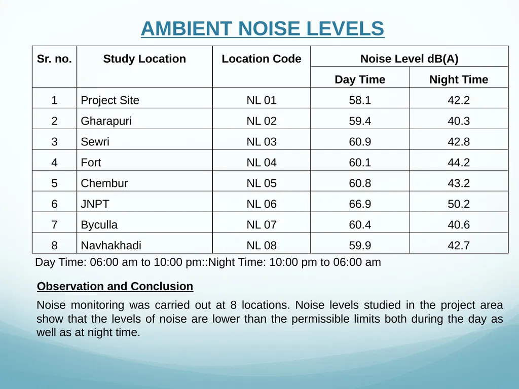
AMBIENT NOISE LEVELS Day Time: 06:00 am to 10:00 pm::Night Time: 10:00 pm to 06:00 am Observation and Conclusion Noise monitoring was carried out at 8 locations. Noise levels studied in the project area show that the levels of noise are lower than the permissible limits both during the day as well as at night time.<br>
65
MARINE WATER QUALITY<br>
66
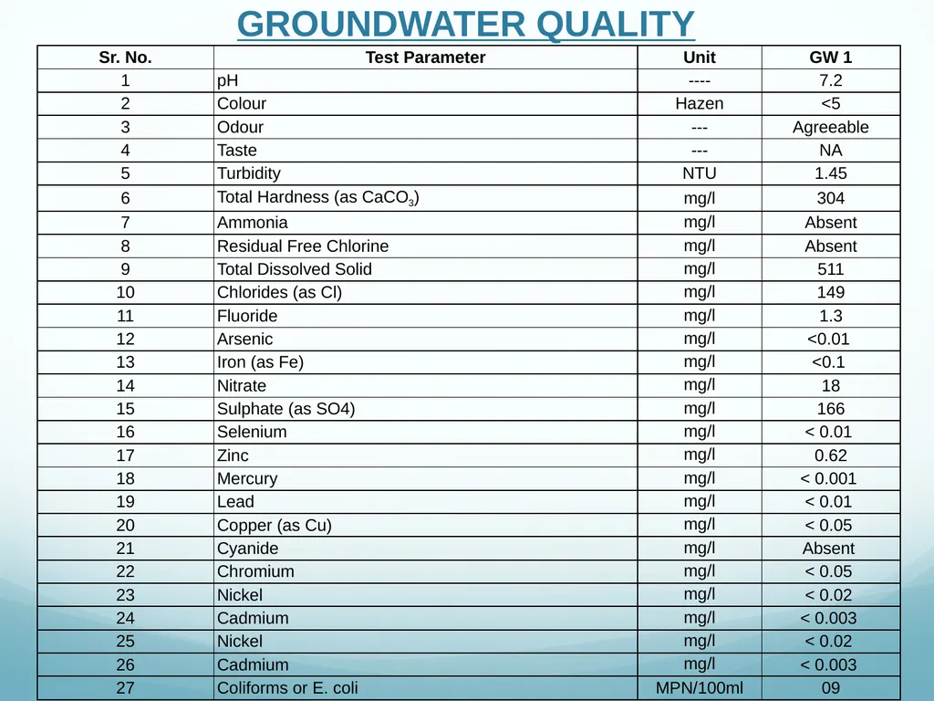
GROUNDWATER QUALITY<br>
67
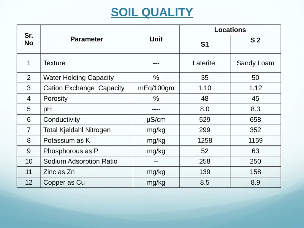
SOIL QUALITY<br>
68
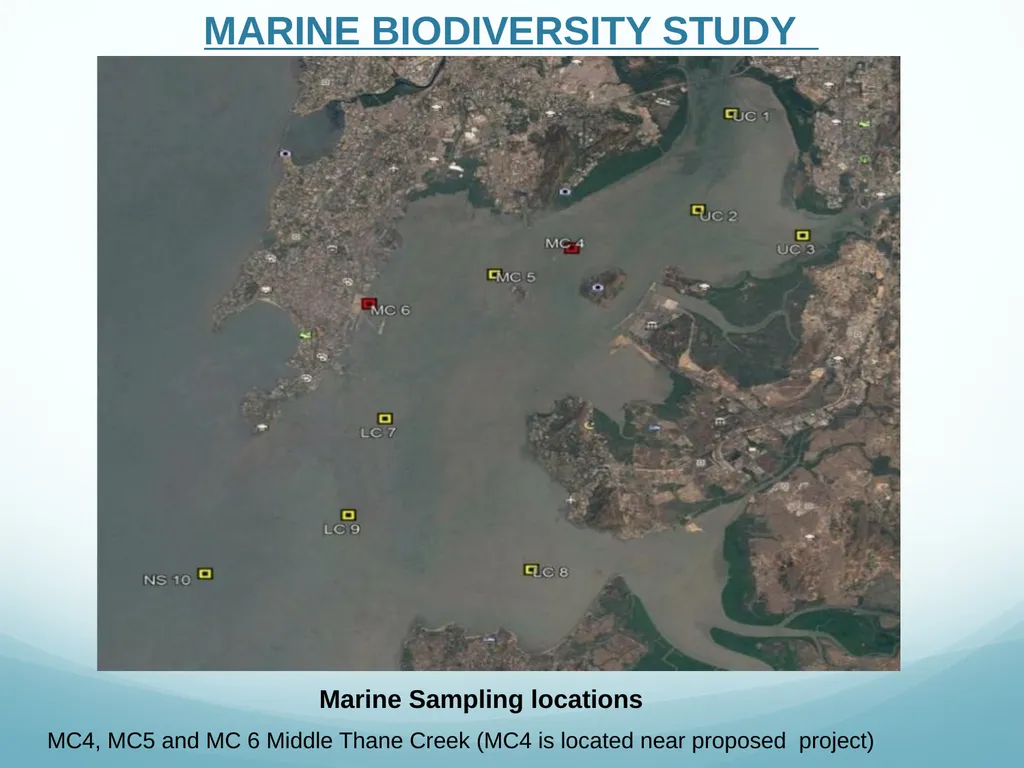
MARINE BIODIVERSITY STUDY Marine Sampling locations MC4, MC5 and MC 6 Middle Thane Creek (MC4 is located near proposed project)<br>
69
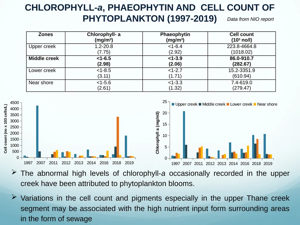
CHLOROPHYLL-a, PHAEOPHYTIN AND CELL COUNT OF PHYTOPLANKTON (1997-2019) The abnormal high levels of chlorophyll-a occasionally recorded in the upper creek have been attributed to phytoplankton blooms.
Variations in the cell count and pigments especially in the upper Thane creek segment may be associated with the high nutrient input form surrounding areas in the form of sewage Data from NIO report<br>
Variations in the cell count and pigments especially in the upper Thane creek segment may be associated with the high nutrient input form surrounding areas in the form of sewage Data from NIO report<br>
70
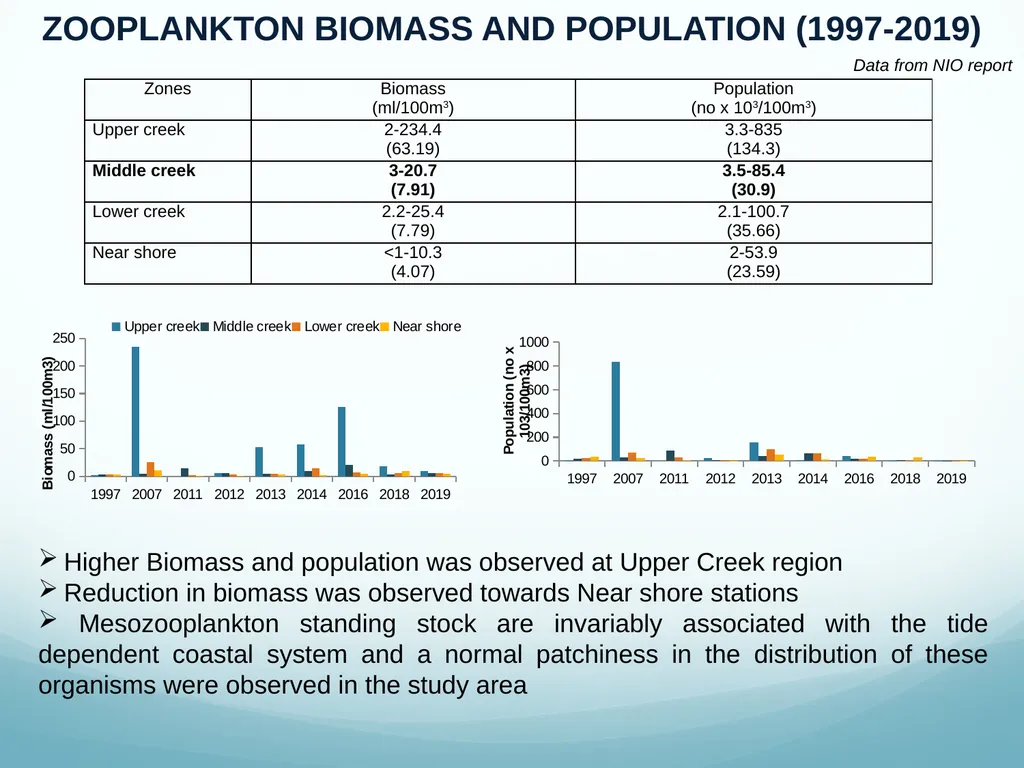
ZOOPLANKTON BIOMASS AND POPULATION (1997-2019) Higher Biomass and population was observed at Upper Creek region
Reduction in biomass was observed towards Near shore stations
Mesozooplankton standing stock are invariably associated with the tide dependent coastal system and a normal patchiness in the distribution of these organisms were observed in the study area Data from NIO report<br>
Reduction in biomass was observed towards Near shore stations
Mesozooplankton standing stock are invariably associated with the tide dependent coastal system and a normal patchiness in the distribution of these organisms were observed in the study area Data from NIO report<br>
71
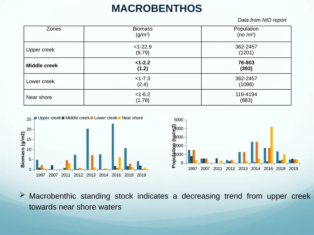
MACROBENTHOS Macrobenthic standing stock indicates a decreasing trend from upper creek towards near shore waters Data from NIO report<br>
72
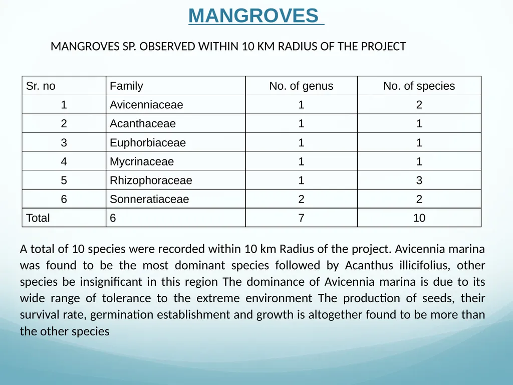
MANGROVES MANGROVES SP. OBSERVED WITHIN 10 KM RADIUS OF THE PROJECT A total of 10 species were recorded within 10 km Radius of the project. Avicennia marina was found to be the most dominant species followed by Acanthus illicifolius, other species be insignificant in this region The dominance of Avicennia marina is due to its wide range of tolerance to the extreme environment The production of seeds, their survival rate, germination establishment and growth is altogether found to be more than the other species<br>
73
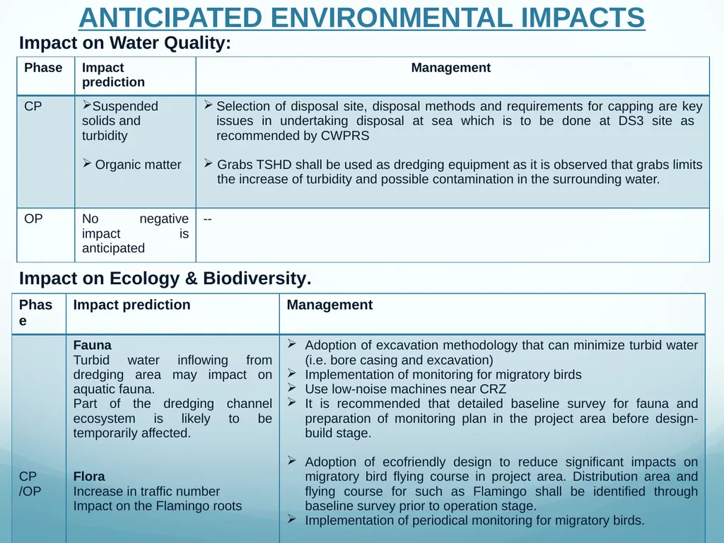
ANTICIPATED ENVIRONMENTAL IMPACTS Impact on Water Quality: Impact on Ecology & Biodiversity.<br>
74
Thank You<br>