
Sea Level Co-Variability Between U.S. Northeast
Description: Sea Level Co-Variability Between U.S. Northeast and Southeast Coasts Ou Wang Science or Technology Question: Interannual sea-level (SL) variations between the United States (U.S.) Northeast and Southeast Coasts are significantly less
Related Topics
Download Presentation
"Sea Level Co-Variability Between U.S. Northeast" is the property of its rightful owner. Permission is granted to download and print the materials on this website for personal, non-commercial use only, and to display it on your personal computer provided you do not modify the materials and that you retain all copyright notices contained in the materials. By downloading content from our website, you accept the terms of this agreement.
Presentation Transcript
slide1. Sea Level Co-Variability Between
U.S. Northeast and Southeast Coasts
Ou Wang Science or Technology Question: Interannual sea-level (SL) variations between the United States (U.S.) Northeast and Southeast Coasts are significantly less correlated than those within their respective sectors. The underlying causes of this discrepancy remain elusive, posing challenges to advancing SL forecasting models along these coastlines.
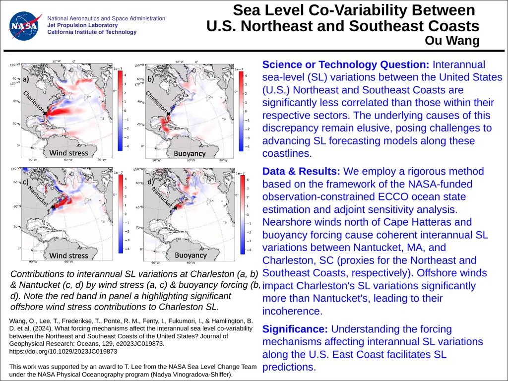
Data & Results: We employ a rigorous method based on the framework of the NASA-funded observation-constrained ECCO ocean state estimation and adjoint sensitivity analysis. Nearshore winds north of Cape Hatteras and buoyancy forcing cause coherent interannual SL variations between Nantucket, MA, and Charleston, SC (proxies for the Northeast and Southeast Coasts, respectively). Offshore winds impact Charleston's SL variations significantly more than Nantucket's, leading to their incoherence.
Significance: Understanding the forcing mechanisms affecting interannual SL variations along the U.S. East Coast facilitates SL predictions. Wang, O., Lee, T., Frederikse, T., Ponte, R. M., Fenty, I., Fukumori, I., & Hamlington, B. D. et al. (2024). What forcing mechanisms affect the interannual sea level co-variability between the Northeast and Southeast Coasts of the United States? Journal of Geophysical Research: Oceans, 129, e2023JC019873. https://doi.org/10.1029/2023JC019873
This work was supported by an award to T. Lee from the NASA Sea Level Change Team under the NASA Physical Oceanography program (Nadya Vinogradova-Shiffer). National Aeronautics and Space Administration
Jet Propulsion Laboratory
California Institute of Technology Contributions to interannual SL variations at Charleston (a, b) & Nantucket (c, d) by wind stress (a, c) & buoyancy forcing (b, d). Note the red band in panel a highlighting significant offshore wind stress contributions to Charleston SL.<br>
slide2. National Aeronautics and Space Administration
Jet Propulsion Laboratory
California Institute of Technology Contact:
Ou Wang, MS 300-323, Jet Propulsion Laboratory, 4800 Oak Grove Dr, Pasadena, CA 91109
Ou.Wang@jpl.nasa.gov
Citation:
Wang, O., Lee, T., Frederikse, T., Ponte, R. M., Fenty, I., Fukumori, I., & Hamlington, B. D. (2024). What forcing mechanisms affect the interannual sea level co-variability between the Northeast and Southeast Coasts of the United States? Journal of Geophysical Research: Oceans, 129, e2023JC019873. https://doi.org/10.1029/2023JC019873
Data Sources:
NASA Physical Oceanography Distributed Active Archive Center (PODAAC), https://podaac.jpl.nasa.gov/ECCO.
Technical Description of Figure:
Forcing influence maps for interannual sea-level anomalies (SLAs) near Charleston, SC, due to (a) wind stress and (b) buoyancy forcing. Panels (c) and (d) are the same as (a) and (b) but for Nantucket, MA. The values represent fractions per unit area (km−2) of variance of total reconstructed interannual SLA at Charleston or Nantucket explained by reconstructed SLA using forcing at each location.
Scientific significance, societal relevance, and relationships to future missions:
Interannual sea-level (SL) variations between the United States (U.S.) Northeast and Southeast Coasts are significantly less correlated than those within their respective sectors. The underlying causes of this discrepancy remain elusive, posing challenges to the advancement of SL forecasting models along these coastlines. Previous studies have used correlation-based analyses to investigate what affects the co-variability of SL variations between the two sectors. However, because correlation does not establish causality, these studies have been unable to pinpoint the causality of the reduced correlation across the two sectors. By using a rigorous adjoint-based method, our study establishes the causality of coastal SL variations by identifying the relative contributions to SL variations as a function of forcing type, location, and lag time. The method is based on data-constrained ocean and sea-ice state estimate from the Estimating the Circulation and Climate of the Ocean (ECCO) project.
By using Nantucket, MA, and Charleston, SC, as the proxies for the U.S. Northeast and Southeast Coasts, respectively, our results indicate that: 1) nearshore winds north of Cape Hatteras and buoyancy forcing cause coherent interannual sea-level variations between Nantucket and Charleston; 2) offshore winds contribute much more to interannual sea-level variation at Charleston than at Nantucket; and 3) offshore winds are the major factor causing incoherent interannual sea-level variations between Nantucket and Charleston.
Understanding the forcing mechanisms affecting interannual SL variations along the densely populated and economically important U.S. East Coast can facilitate the advancement of SL forecasting models along this coastline, including those using machine-learning methods.<br>
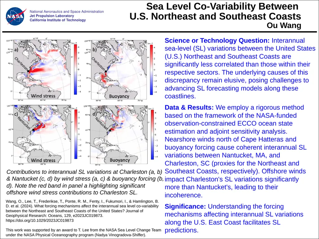
Data & Results: We employ a rigorous method based on the framework of the NASA-funded observation-constrained ECCO ocean state estimation and adjoint sensitivity analysis. Nearshore winds north of Cape Hatteras and buoyancy forcing cause coherent interannual SL variations between Nantucket, MA, and Charleston, SC (proxies for the Northeast and Southeast Coasts, respectively). Offshore winds impact Charleston's SL variations significantly more than Nantucket's, leading to their incoherence.
Significance: Understanding the forcing mechanisms affecting interannual SL variations along the U.S. East Coast facilitates SL predictions. Wang, O., Lee, T., Frederikse, T., Ponte, R. M., Fenty, I., Fukumori, I., & Hamlington, B. D. et al. (2024). What forcing mechanisms affect the interannual sea level co-variability between the Northeast and Southeast Coasts of the United States? Journal of Geophysical Research: Oceans, 129, e2023JC019873. https://doi.org/10.1029/2023JC019873
This work was supported by an award to T. Lee from the NASA Sea Level Change Team under the NASA Physical Oceanography program (Nadya Vinogradova-Shiffer). National Aeronautics and Space Administration
Jet Propulsion Laboratory
California Institute of Technology Contributions to interannual SL variations at Charleston (a, b) & Nantucket (c, d) by wind stress (a, c) & buoyancy forcing (b, d). Note the red band in panel a highlighting significant offshore wind stress contributions to Charleston SL.<br>
slide2. National Aeronautics and Space Administration
Jet Propulsion Laboratory
California Institute of Technology Contact:
Ou Wang, MS 300-323, Jet Propulsion Laboratory, 4800 Oak Grove Dr, Pasadena, CA 91109
Ou.Wang@jpl.nasa.gov
Citation:
Wang, O., Lee, T., Frederikse, T., Ponte, R. M., Fenty, I., Fukumori, I., & Hamlington, B. D. (2024). What forcing mechanisms affect the interannual sea level co-variability between the Northeast and Southeast Coasts of the United States? Journal of Geophysical Research: Oceans, 129, e2023JC019873. https://doi.org/10.1029/2023JC019873
Data Sources:
NASA Physical Oceanography Distributed Active Archive Center (PODAAC), https://podaac.jpl.nasa.gov/ECCO.
Technical Description of Figure:
Forcing influence maps for interannual sea-level anomalies (SLAs) near Charleston, SC, due to (a) wind stress and (b) buoyancy forcing. Panels (c) and (d) are the same as (a) and (b) but for Nantucket, MA. The values represent fractions per unit area (km−2) of variance of total reconstructed interannual SLA at Charleston or Nantucket explained by reconstructed SLA using forcing at each location.
Scientific significance, societal relevance, and relationships to future missions:
Interannual sea-level (SL) variations between the United States (U.S.) Northeast and Southeast Coasts are significantly less correlated than those within their respective sectors. The underlying causes of this discrepancy remain elusive, posing challenges to the advancement of SL forecasting models along these coastlines. Previous studies have used correlation-based analyses to investigate what affects the co-variability of SL variations between the two sectors. However, because correlation does not establish causality, these studies have been unable to pinpoint the causality of the reduced correlation across the two sectors. By using a rigorous adjoint-based method, our study establishes the causality of coastal SL variations by identifying the relative contributions to SL variations as a function of forcing type, location, and lag time. The method is based on data-constrained ocean and sea-ice state estimate from the Estimating the Circulation and Climate of the Ocean (ECCO) project.
By using Nantucket, MA, and Charleston, SC, as the proxies for the U.S. Northeast and Southeast Coasts, respectively, our results indicate that: 1) nearshore winds north of Cape Hatteras and buoyancy forcing cause coherent interannual sea-level variations between Nantucket and Charleston; 2) offshore winds contribute much more to interannual sea-level variation at Charleston than at Nantucket; and 3) offshore winds are the major factor causing incoherent interannual sea-level variations between Nantucket and Charleston.
Understanding the forcing mechanisms affecting interannual SL variations along the densely populated and economically important U.S. East Coast can facilitate the advancement of SL forecasting models along this coastline, including those using machine-learning methods.<br>