
Subject: Climatology Topic: Classification of
MS
Published · 8 slides · 0 views

1 / 1





Description
Subject: Climatology Topic: Classification of Climate Presented by: Hiba Gul Climatic changes Links to Climate Data Sources GIS-based map interface provides access to US and global climateweather data. This is a listing of variable types
Related Topics
Share
Embed code
Download this presentation From Below
"Subject: Climatology Topic: Classification of" is the property of its rightful owner. Permission is granted to download and print the materials on this website for personal, non-commercial use only, and to display it on your personal computer provided you do not modify the materials and that you retain all copyright notices contained in the materials. By downloading content from our website, you accept the terms of this agreement.
Presentation Transcript
01
Subject: Climatology
Topic: Classification of Climate
Presented by: Hiba Gul<br>
Topic: Classification of Climate
Presented by: Hiba Gul<br>
02
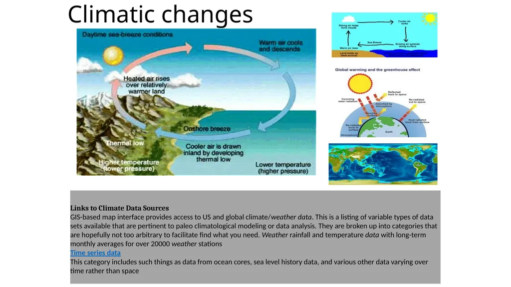
Climatic changes Links to Climate Data Sources
GIS-based map interface provides access to US and global climate/weather data. This is a listing of variable types of data sets available that are pertinent to paleo climatological modeling or data analysis. They are broken up into categories that are hopefully not too arbitrary to facilitate find what you need. Weather rainfall and temperature data with long-term monthly averages for over 20000 weather stations
Time series data
This category includes such things as data from ocean cores, sea level history data, and various other data varying over time rather than space<br>
GIS-based map interface provides access to US and global climate/weather data. This is a listing of variable types of data sets available that are pertinent to paleo climatological modeling or data analysis. They are broken up into categories that are hopefully not too arbitrary to facilitate find what you need. Weather rainfall and temperature data with long-term monthly averages for over 20000 weather stations
Time series data
This category includes such things as data from ocean cores, sea level history data, and various other data varying over time rather than space<br>
03
Classification of climates climate classification system. The system is based on the concept that native vegetation is the best expression of climate. Thus, climate zone boundaries have been selected with vegetation distribution in mind. It combines average annual and monthly temperatures and precipitation, and the seasonality of precipitation.
1 .1 GROUP A: Tropical/megathermal climates
1.2 GROUP B: Dry (arid and semiarid) climates ·
1.3 GROUP C: Mild Temperate/mesothermal climates
1.4 GROUP D: Continental/microthermal climate ·
1.5 GROUP E: Polar climates<br>
1 .1 GROUP A: Tropical/megathermal climates
1.2 GROUP B: Dry (arid and semiarid) climates ·
1.3 GROUP C: Mild Temperate/mesothermal climates
1.4 GROUP D: Continental/microthermal climate ·
1.5 GROUP E: Polar climates<br>
04
Tropical climates are characterized by constant high temperature (at sea level and low elevations) — all twelve months of the year have average temperatures of 18 °C (64 °F) or higher. They are subdivided as follows:Tropical rainforest climate All twelve months have average precipitation of at least 60 mm (2.4 in). These climates usually occur within 5–10° latitude of the equator. In some eastern-coast areas, they may extend to as much as 25° away from the equator. This climate is dominated by the Doldrums Low Pressure System all year round, and therefore has no natural seasons.
Some of the places that have this climate are indeed uniformly and monotonously wet throughout the year (e.g., the northwest Pacific coast of South and Central America, from Ecuador to Costa Rica, see for instance, Andagoya, Colombia), but in many cases the period of higher sun and longer days is distinctly wettest (as at Palembang, Indonesia) or the time of lower sun and shorter days may have more rain (as at Sitiawan, Malaysia).
A few places with this climate are found at the outer edge of the tropics, almost exclusively in the Southern Hemisphere; one example is Santos, Brazil.
Tropical monsoon climate (Am):This type of climate, most common in South America, results from the monsoon winds which change direction according to the seasons. This climate has a driest month (which nearly always occurs at or soon after the "winter" solstice for that side of the equator) with rainfall less than 60 mm, but more than (100 − [total annual precipitation {mm}/25]). Examples: Cairns, Queensland, Australia Miami, Florida, United States There is also another scenario under which some places fit into this category; this is referred to as the trade-wind littoral climate because easterly winds bring enough precipitation during the "winter" months to prevent the climate from becoming a tropical wet-and-dry climate. Nassau, Bahamas is included among these locations.
Tropical wet and dry or savanna climate :These climates have a pronounced dry season, with the driest month having precipitation less than 60 mm and also less than (100 − [total annual precipitation {mm}/25]). Examples: Darwin, Northern Territory, Australia Caracas, Venezuela
Mumbai, India Bangkok, Thailand
GROUP B: Dry (arid and semiarid) climates
These climates are characterized by the fact that actual precipitation is less than a threshold value set equal to the potential evapo transpiration. The threshold value (in millimeters) is determined as follows:
If the annual precipitation is less than 50% of this threshold, the classification is BW (desert climate); if it is in the range of 50%-100% of the threshold, the classification is BS (steppe climate).
Desert areas situated along the west coasts of continents at tropical or near-tropical locations are characterized by cooler temperatures than encountered elsewhere at comparable latitudes (due to the nearby presence of cold ocean currents) and frequent fog and low clouds, despite the fact that these places rank among the driest on earth in terms of actual precipitation received. This climate examples can be found at Lima, Peru, and Walvis Bay, Namibia.<br>
Some of the places that have this climate are indeed uniformly and monotonously wet throughout the year (e.g., the northwest Pacific coast of South and Central America, from Ecuador to Costa Rica, see for instance, Andagoya, Colombia), but in many cases the period of higher sun and longer days is distinctly wettest (as at Palembang, Indonesia) or the time of lower sun and shorter days may have more rain (as at Sitiawan, Malaysia).
A few places with this climate are found at the outer edge of the tropics, almost exclusively in the Southern Hemisphere; one example is Santos, Brazil.
Tropical monsoon climate (Am):This type of climate, most common in South America, results from the monsoon winds which change direction according to the seasons. This climate has a driest month (which nearly always occurs at or soon after the "winter" solstice for that side of the equator) with rainfall less than 60 mm, but more than (100 − [total annual precipitation {mm}/25]). Examples: Cairns, Queensland, Australia Miami, Florida, United States There is also another scenario under which some places fit into this category; this is referred to as the trade-wind littoral climate because easterly winds bring enough precipitation during the "winter" months to prevent the climate from becoming a tropical wet-and-dry climate. Nassau, Bahamas is included among these locations.
Tropical wet and dry or savanna climate :These climates have a pronounced dry season, with the driest month having precipitation less than 60 mm and also less than (100 − [total annual precipitation {mm}/25]). Examples: Darwin, Northern Territory, Australia Caracas, Venezuela
Mumbai, India Bangkok, Thailand
GROUP B: Dry (arid and semiarid) climates
These climates are characterized by the fact that actual precipitation is less than a threshold value set equal to the potential evapo transpiration. The threshold value (in millimeters) is determined as follows:
If the annual precipitation is less than 50% of this threshold, the classification is BW (desert climate); if it is in the range of 50%-100% of the threshold, the classification is BS (steppe climate).
Desert areas situated along the west coasts of continents at tropical or near-tropical locations are characterized by cooler temperatures than encountered elsewhere at comparable latitudes (due to the nearby presence of cold ocean currents) and frequent fog and low clouds, despite the fact that these places rank among the driest on earth in terms of actual precipitation received. This climate examples can be found at Lima, Peru, and Walvis Bay, Namibia.<br>
05
Introduction
Regions having similar characteristic features of climate are grouped under one climatic zone. According to a recent code of Bureau of Indian Standards, the country may be divided into five major climatic zones:
1 Hot & Dry (mean monthly temperature >30 and relative humidity <55%);
2 Warm & Humid (mean monthly temperature >25-30 and relative humidity >55-75%);
3 Temperate (mean monthly temperature 25-30 and relative humidity <75%);
4 Cold (mean monthly temperature <25 and relative humidity – all values);
5 Composite (This applies, when six months or more do not fall within any of the other categories)
India Climate can be divided into mainly four zones namely, Alpine, Sub tropical, Tropical and Arid. Situated roughly between 8º N and 37º NBrief Description Buildings in different climatic zones require different passive features to make structures energy-efficient. Some features that can be adopted in particular zones are listed below.
Hot and dry
The hot and dry zone lies in the western and the central part of India; Jaisalmer, Jodhpur and Sholapur are some of the towns that experience this type of climate.
In such a climate, it is imperative to control solar radiation and movement of hot winds. The design criteria should therefore aim at resisting heat gain by providing shading, reducing exposed area, controlling and scheduling ventilation, and increasing thermal capacity. The presence of “water bodies” is desirable as they can help increase the humidity, thereby leading to lower air temperatures. The ground and surrounding objects emit a lot of heat in the afternoons and evenings. As far as possible, this heat should be avoided by appropriate design features.
Some of the design features for buildings in this climate are: Appropriate orientation and shape of building Insulation of building envelope Massive structure Air locks, lobbies, balconies, and verandahs Weather stripping and scheduling air changes External surfaces protected by overhangs, fins, and trees Pale colours and glazed china mosaic tiles Windows and exhausts Courtyards, wind towers, and arrangement of openings Trees, ponds, and evaporative cooling Climatic Zones of India<br>
Regions having similar characteristic features of climate are grouped under one climatic zone. According to a recent code of Bureau of Indian Standards, the country may be divided into five major climatic zones:
1 Hot & Dry (mean monthly temperature >30 and relative humidity <55%);
2 Warm & Humid (mean monthly temperature >25-30 and relative humidity >55-75%);
3 Temperate (mean monthly temperature 25-30 and relative humidity <75%);
4 Cold (mean monthly temperature <25 and relative humidity – all values);
5 Composite (This applies, when six months or more do not fall within any of the other categories)
India Climate can be divided into mainly four zones namely, Alpine, Sub tropical, Tropical and Arid. Situated roughly between 8º N and 37º NBrief Description Buildings in different climatic zones require different passive features to make structures energy-efficient. Some features that can be adopted in particular zones are listed below.
Hot and dry
The hot and dry zone lies in the western and the central part of India; Jaisalmer, Jodhpur and Sholapur are some of the towns that experience this type of climate.
In such a climate, it is imperative to control solar radiation and movement of hot winds. The design criteria should therefore aim at resisting heat gain by providing shading, reducing exposed area, controlling and scheduling ventilation, and increasing thermal capacity. The presence of “water bodies” is desirable as they can help increase the humidity, thereby leading to lower air temperatures. The ground and surrounding objects emit a lot of heat in the afternoons and evenings. As far as possible, this heat should be avoided by appropriate design features.
Some of the design features for buildings in this climate are: Appropriate orientation and shape of building Insulation of building envelope Massive structure Air locks, lobbies, balconies, and verandahs Weather stripping and scheduling air changes External surfaces protected by overhangs, fins, and trees Pale colours and glazed china mosaic tiles Windows and exhausts Courtyards, wind towers, and arrangement of openings Trees, ponds, and evaporative cooling Climatic Zones of India<br>
06
Warm and humid
The warm and humid zone covers the coastal parts of the country, such as Mumbai, Chennai and Kolkata. The main design criteria in the warm and humid region are to reduce heat gain by providing shading, and promote heat loss by maximizing cross ventilation. Dissipation of humidity is also essential to reduce discomfort.
Moderate ; Pune and Bangalore are examples of cities that fall under this climatic zone. The design criteria in the moderate zone are to reduce heat gain by providing shading, and to promote heat loss by ventilation.
Some of the design features for buildings in this climate are:
Appropriate orientation and shape of building Roof insulation and east and west wall insulation Walls facing east and west, glass surface protected by overhangs, fins, and trees Pale colours and glazed china mosaic tiles Windows and exhausts Courtyards and arrangement of openings
Cold ; Generally, the northern part of India experiences this type of climate. the design criteria are to resist heat loss by insulation and controlling infiltration. Simultaneously, heat gain needs to be promoted by admitting and trapping solar radiation within the living space.
Some of the design features for buildings in this climate are:
Appropriate orientation and shape of building Use of trees as wind barriers Roof insulation, wall insulation, and double glazing Thicker walls Air locks and lobbies Weather stripping Darker colours Sun spaces, greenhouses and trombe walls (One of the simplest and most elegant solutions to retain solar heat is the Trombe wall, where solar heat is collected and stored in a wall of high thermal mass, tempering the heat gain during the day and releasing it at night. )
The Trombe wall is named after a French engineer Félix Trombe in the 1970s particularly well-suited to sunny climates that have high diurnal (day-night) temperature swings.
Composite
The composite zone covers the central part of India, such as New Delhi, Kanpur and Allahabad. The design criteria are more or less the same as for hot and dry climate except that maximizing cross ventilation is desirable in the monsoon period.
Some of the design features for buildings in this climate are:
Appropriate orientation and shape of building Use of trees as wind barriers Roof insulation and wall insulation Thicker walls Air locks and balconies Weather stripping Walls, glass surfaces protected by overhangs, fins, and trees Pale colours and glazed china mosaic tiles Exhausts Courtyards, wind towers, and arrangement of openings Trees and ponds for evaporative cooling Dehumidifiers and desiccant cooling<br>
Moderate ; Pune and Bangalore are examples of cities that fall under this climatic zone. The design criteria in the moderate zone are to reduce heat gain by providing shading, and to promote heat loss by ventilation.
Some of the design features for buildings in this climate are:
Appropriate orientation and shape of building Roof insulation and east and west wall insulation Walls facing east and west, glass surface protected by overhangs, fins, and trees Pale colours and glazed china mosaic tiles Windows and exhausts Courtyards and arrangement of openings
Cold ; Generally, the northern part of India experiences this type of climate. the design criteria are to resist heat loss by insulation and controlling infiltration. Simultaneously, heat gain needs to be promoted by admitting and trapping solar radiation within the living space.
Some of the design features for buildings in this climate are:
Appropriate orientation and shape of building Use of trees as wind barriers Roof insulation, wall insulation, and double glazing Thicker walls Air locks and lobbies Weather stripping Darker colours Sun spaces, greenhouses and trombe walls (One of the simplest and most elegant solutions to retain solar heat is the Trombe wall, where solar heat is collected and stored in a wall of high thermal mass, tempering the heat gain during the day and releasing it at night. )
The Trombe wall is named after a French engineer Félix Trombe in the 1970s particularly well-suited to sunny climates that have high diurnal (day-night) temperature swings.
Composite
The composite zone covers the central part of India, such as New Delhi, Kanpur and Allahabad. The design criteria are more or less the same as for hot and dry climate except that maximizing cross ventilation is desirable in the monsoon period.
Some of the design features for buildings in this climate are:
Appropriate orientation and shape of building Use of trees as wind barriers Roof insulation and wall insulation Thicker walls Air locks and balconies Weather stripping Walls, glass surfaces protected by overhangs, fins, and trees Pale colours and glazed china mosaic tiles Exhausts Courtyards, wind towers, and arrangement of openings Trees and ponds for evaporative cooling Dehumidifiers and desiccant cooling<br>
07
Thermal comforts & Effects of climate
Thermal comfort is affected by heat conduction, convection, radiation, and evaporative heat loss. Thermal comfort is maintained when the heat generated by human metabolism is allowed to dissipate, thus maintaining thermal equilibrium with the surroundings. It has been long recognized that the sensation of feeling hot or cold is not just dependent on air temperature alone.
Thermal comfort is the condition of mind that expresses satisfaction with the thermal environment and is assessed by subjective evaluation Maintaining this standard of thermal comfort for occupants of buildings or other enclosures is one of the important goals of HVAC (heating, ventilation, and air conditioning) design engineers
Sex differences
While thermal comfort preferences between genders seems to be small, there are some differences. Studies have found men report discomfort due to rises in temperature much earlier than women. Men also estimate higher levels of their sensation of discomfort than women
Effects of thermal discomfort
Thermal discomfort has been known to lead to sick building syndrome symptoms. The combination of high temperature and high relative humidity serves to reduce thermal comfort and indoor air quality. The occurrence of symptoms increased much more with raised indoor temperatures in the winter than in the summer due to the larger difference created between indoor and outdoor temperatures
Since there are large variations from person to person in terms of physiological and psychological satisfaction, it is hard to find an optimal temperature for everyone in a given space. Laboratory and field data have been collected to define conditions that will be found comfortable for a specified percentage of occupants. There are six primary factors that directly affect thermal comfort that can be grouped in two categories: personal factors - because they are characteristics of the occupants - and environmental factors - which are conditions of the thermal environment. The former are metabolic rate and clothing level, the latter are air temperature, radiant temperature, air speed and humidity.
Even if all these factors may vary with time, standards usually refer to a steady state to study thermal comfort, just allowing limited temperature variations
Air temperature
Main article: Dry-bulb temperature
The air temperature is the average temperature of the air surrounding the occupant, with respect to location and time. According to ASHRAE 55 standard, the spatial average takes into account the ankle, waist and head levels, which vary for seated or standing occupants Air temperature is measured with a dry-bulb thermometer and for this reason it is also known as dry-bulb temperature.<br>
Effects of thermal discomfort
Thermal discomfort has been known to lead to sick building syndrome symptoms. The combination of high temperature and high relative humidity serves to reduce thermal comfort and indoor air quality. The occurrence of symptoms increased much more with raised indoor temperatures in the winter than in the summer due to the larger difference created between indoor and outdoor temperatures
Since there are large variations from person to person in terms of physiological and psychological satisfaction, it is hard to find an optimal temperature for everyone in a given space. Laboratory and field data have been collected to define conditions that will be found comfortable for a specified percentage of occupants. There are six primary factors that directly affect thermal comfort that can be grouped in two categories: personal factors - because they are characteristics of the occupants - and environmental factors - which are conditions of the thermal environment. The former are metabolic rate and clothing level, the latter are air temperature, radiant temperature, air speed and humidity.
Even if all these factors may vary with time, standards usually refer to a steady state to study thermal comfort, just allowing limited temperature variations
Air temperature
Main article: Dry-bulb temperature
The air temperature is the average temperature of the air surrounding the occupant, with respect to location and time. According to ASHRAE 55 standard, the spatial average takes into account the ankle, waist and head levels, which vary for seated or standing occupants Air temperature is measured with a dry-bulb thermometer and for this reason it is also known as dry-bulb temperature.<br>
08
Radiant temperature
Main article: Mean radiant temperature
The radiant temperature is related to the amount of radiant heat transferred from a surface, and it depends on the emissivity of the material - i.e. the ability to absorb or emit heat. The mean radiant temperature, defined as the uniform temperature of an imaginary enclosure in which the radiant heat transfer from the human body is equal to the radiant heat transfer in the actual non-uniform enclosure, is a key variable for thermal comfort calculations for the human body.
Air speed Air speed is defined as the rate of air movement at a point, without regard to direction. According to ASHRAE 55 standard, it is the average speed of the air to which the body is exposed, with respect to location and time. The temporal average is the same as the air temperature, while the spatial average is based on the assumption that the body is exposed to a uniform air speed, according to the SET thermo-physiological model. However, some spaces might provide strongly non uniform air velocity fields and consequent skin heat losses that cannot be considered uniform. Therefore, the designer shall decide the proper averaging, especially including air speeds incident on unclothed body parts, that have greater cooling effect and potential for local discomfort.
Relative humidity While the human body has sensors within the skin that are fairly efficient at feeling heat and cold, relative humidity (RH) is harder to detect. The influence of humidity on the perception of an indoor environment can play a part in the perceived temperature and their thermal comfort. As a matter of fact, relative humidity affects the evaporation from the skin, which is the prevailing way of heat loss at high temperatures, normally from 26°C (80°F). At lower RH more sweat is allowed to evaporate from the body, while at higher values it is harder for this process to happen, because the air's moisture content is already elevated. Therefore, very humid environments (RH > 70-80%) are usually uncomfortable because the air is close to the saturation level, thus strongly reducing the possibility of heat loss through evaporation. On the other hand, very dry environments (RH < 20-30%) are also uncomfortable because of their effect on the mucous membranes. The recommended level of indoor humidity is in the range of 30-60%, but new methods allow lower and higher humidities, depending on the other factors involved in thermal comfort<br>
Air speed Air speed is defined as the rate of air movement at a point, without regard to direction. According to ASHRAE 55 standard, it is the average speed of the air to which the body is exposed, with respect to location and time. The temporal average is the same as the air temperature, while the spatial average is based on the assumption that the body is exposed to a uniform air speed, according to the SET thermo-physiological model. However, some spaces might provide strongly non uniform air velocity fields and consequent skin heat losses that cannot be considered uniform. Therefore, the designer shall decide the proper averaging, especially including air speeds incident on unclothed body parts, that have greater cooling effect and potential for local discomfort.
Relative humidity While the human body has sensors within the skin that are fairly efficient at feeling heat and cold, relative humidity (RH) is harder to detect. The influence of humidity on the perception of an indoor environment can play a part in the perceived temperature and their thermal comfort. As a matter of fact, relative humidity affects the evaporation from the skin, which is the prevailing way of heat loss at high temperatures, normally from 26°C (80°F). At lower RH more sweat is allowed to evaporate from the body, while at higher values it is harder for this process to happen, because the air's moisture content is already elevated. Therefore, very humid environments (RH > 70-80%) are usually uncomfortable because the air is close to the saturation level, thus strongly reducing the possibility of heat loss through evaporation. On the other hand, very dry environments (RH < 20-30%) are also uncomfortable because of their effect on the mucous membranes. The recommended level of indoor humidity is in the range of 30-60%, but new methods allow lower and higher humidities, depending on the other factors involved in thermal comfort<br>