/
Using Specific Differential Phase to Predict Significant Severe Thunderstorm Wind Damage Using Specific Differential Phase to Predict Significant Severe Thunderstorm Wind Damage

Using Specific Differential Phase to Predict Significant Severe Thunderstorm Wind Damage - PowerPoint Presentation

yoshiko-marsland
yoshiko-marsland . @yoshiko-marsland
Follow
362 views
Uploaded On 2019-06-26

Using Specific Differential Phase to Predict Significant Severe Thunderstorm Wind Damage - PPT Presentation

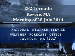
Brian J Frugis NOAANWS Albany New York NROW XIX 7 November 2018 Motivation Determining severe vs significant severe thunderstorms can be difficult for a warning meteorologist This has been a challenge for NWS Albany ALY forecasters on several occasions during the summers of 2016 ID: 760342

damage significant warning kdp significant damage kdp warning severe radar wind thunderstorms elevated kenx deg column albany time cross

Share:

Link:

Embed:

Download Presentation from below link

Download Presentation The PPT/PDF document "Using Specific Differential Phase to Pre..." is the property of its rightful owner. Permission is granted to download and print the materials on this web site for personal, non-commercial use only, and to display it on your personal computer provided you do not modify the materials and that you retain all copyright notices contained in the materials. By downloading content from our website, you accept the terms of this agreement.


Presentation Transcript

Slide1

Using Specific Differential Phase to Predict Significant Severe Thunderstorm Wind Damage across the Northeastern United States

Brian J.

Frugis

NOAA/NWS Albany, New York

NROW XIX – 7 November 2018

Slide2

Motivation

Determining severe vs. significant severe thunderstorms can be difficult for a warning meteorologist.

This

has been a challenge for NWS Albany (ALY) forecasters on several occasions during the summers of 2016 & 2017. Several significant thunderstorms were either missed or under warned.

Impact-based

warnings requires the warning forecaster to have specific knowledge of wind speeds & damage potential for warning text/graphics.

New

technology and warning techniques being investigated in research need to be implemented into operations

.

Slide3

What is a Significant Severe Thunderstorm?

SPC considers thunderstorms that produce wind gust of 65

kts

(75 MPH), hail two inches in diameter or greater, and/or an EF2+ tornado to be significant

For the purpose of this study, will also consider thunderstorms that produce injuries or deaths to be significant as well

Slide4

Significant Severe Thunderstorm Climatology for Northeast*

*For the purpose of this study, Northeast is considered New England, New York, New Jersey, Delaware, northeastern Maryland & Central and Eastern Pennsylvania

Slide5

Significant Severe Wind vs. Tornadoes

There were 261 significant severe wind reports in the Northeast between 2012 and 2017 and only 138 tornadic events of any strength (EF0+) reported in that same time.

Slide6

WFO Albany: Percentage of Significant Events 2012 to 2017

Out of the 1423 severe wind reports received to WFO Albany between 2012 and 2017, only 46 (about 3%) were considered significant

Slide7

Radar Limitations Always Need to Be Kept in Mind

Images from NOAA/NWS Warning Decision Training Division (WDTD)

Radar & Applications Course (RAC, formerly DLOC)

Slide8

Beam Blockage from KENX

Catskill Mountains south of KENX cause considerable beam blockage. This is an issue for storms that develop over the high terrain and then track eastward into the mid-Hudson Valley, as it may underestimate strength of storms headed towards populated areas around Kingston and Poughkeepsie.

Slide9

Good Rule of Thumb from Warning Decision Training Division (WDTD)

Radar and Applications Course (RAC), Topic 2, Lesson 7 “Radar Sampling Issues”

Slide10

Radar Analysis of Significant Severe Thunderstorms

Radar data from the Albany KENX WSR-88D was examined for the 46 thunderstorms that produced significant wind damage across the Albany WFO CWA from 2012 to 2017. Several radar-based parameters, such as storm type, radial velocity and Specific Differential Phase (KDP), were collected at the time of and just prior to the time of the damage report via GR2Analyst software.

Slide11

Radial Velocity Analysis

Slide12

Specific Differential Phase (KDP)

Out of the 46 storms analyzed, 30 of them showed an elevated KDP column suspended aloft for several scans before the wind damage occurred. This KDP column collapsed towards the surface at the time of the wind damage report as a result of a wet microburst. Within the 30 times this was noted, 22 of those events were associated with supercell thunderstorms.

The highest K

DP

value within the suspended column aloft averaged to be 7.6

deg

/km within these thunderstorms & the median value was 7.0

deg

/km.

Slide13

Max KDP Height Over Time

Typical Radar Volume Scan Lasts 4 to 6 minutes

Slide14

Max KDP Value Over Time

Typical Radar Volume Scan Lasts 4 to 6 minutes

Slide15

Example of Lowering KDP Core

3 July 2014 over southern Herkimer County, New York

Type

of storm: Supercell

Max KDP Value: 8.8

deg

/km

Significant damage occurred at 2014Z in hamlet of

Jordanville

.

Elevated KDP core was seen at least 12 minutes before significant damage occurred

Slide16

Descending KDP Column During a Squall Line Event

KENX K

DP

Cross-section

13 Aug 2016 2214Z

KENX KDP Cross-section13 Aug 2016 2220Z

KENX KDP Cross-section13 Aug 2016 2226Z

Cross-section of K

DP

from KENX show the elevated K

DP

column falling down to the surface on 13

August

2016 thanks to a strong microburst within a severe squall line. Significant damage occurred at

2225Z

at the Pine Lake Campground in the town of Caroga in Fulton County, New York. The max value of the K

DP

within the elevated column was around 5.6

deg

/km.

Slide17

KDP vs. Z

A comparison of vertical cross-sections of K

DP

and Z from 30 June 2017 at 2016Z near

Ravena

, NY. This storm would go on to produce significant damage in South

Schodack

, NY at 2028Z. The elevated K

DP

core was around 8

deg

/km around 10,000 ft. The K

DP

core aloft is easier to pick out for a warning forecaster compared to the broad area of 50+

dBZ

within the Z cross-section.

Slide18

Use During Warning Process

While

a warning forecaster is interrogating other base data products, they can look for building columns of K

DP

within a thunderstorm.

If

values appear to remain elevated and reach critical values (around 6

deg

/km based off this study), a warning decision forecaster can anticipate an increased chance for significant damage when this column collapses towards the surface.

While

base velocity can have its flaws based on beam angle and direction, K

DP

columns can help alleviate this limitation.

Still

, inherent issues with beam width and terrain blockage will cause issues when evaluating K

DP

as well.

In

addition, storms that contain large hail may not always show K

DP

columns, as K

DP

is not plotted when associated with low values of correlation coefficient (<0.90).

Slide19

Other Considerations & Future Work

The depth of the mixing layer was measured to see if high cores of K

DP

above this layer were able to still make it to the surface

Mixing layer depth varied considerably from 1000

ft

to 9000

ft

Having a small mixed layer did not prevent high K

DP

cores from making it down to the surface

Low level lapse rates within the mixed layer were typically rather steep

Average values were 10

°/km (basically dry adiabatic)

Null cases will need to be examined to see how often high K

DP

cores don’t make it down to the surface and why that may be the case

Slide20

Summary

Significant severe thunderstorms do occur over the Northeastern United States, with significant wind damage being the highest threat

.

Determining if a severe thunderstorm will produce significant damage can be difficult at times for warning forecasters to pick out based on radial (pure) velocity alone. Knowing how strong a thunderstorm will be is valuable information for impact-based warnings

.

Radar limitations (beam blockage, larger angles, distance from RDA) can all have an impact on the quality of radar data and need to be kept in mind during warning decisions

.

Slide21

Summary

Watching for collapsing K

DP

columns may be helpful during the warning process, especially within supercells with elevated K

DP

values of greater than 6.5 to 7

deg

/km.

This feature has been seen mostly in supercells, but also has some potential in squall line cases as well

.

Additional cases, including null cases, will need to be examined over the next few years to fully learn the utility of these items

.

Slide22

Questions?

Brian.Frugis@noaa.gov