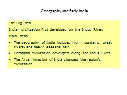
PPT-Ancient India Geography of India

Author : calandra-battersby | Published Date : 2018-10-14

India is considered a subcontinent because of its size It is actually a part of Asia In the north are high mountains the Himalayas and Hindu Kush In the center is

Presentation Embed Code

Download Presentation

Download Presentation The PPT/PDF document "Ancient India Geography of India" is the property of its rightful owner. Permission is granted to download and print the materials on this website for personal, non-commercial use only, and to display it on your personal computer provided you do not modify the materials and that you retain all copyright notices contained in the materials. By downloading content from our website, you accept the terms of this agreement.

Ancient India Geography of India: Transcript


India is considered a subcontinent because of its size It is actually a part of Asia In the north are high mountains the Himalayas and Hindu Kush In the center is the Deccan Plateau Himalayan Mts. In this lesson you will read about the contributions made by ancient Indians in the field of Mathematics and Science including Medical Science Ayurveda Yoga Astronomy Astrology etc You will be surprised to know that a lot of scientific knowledge was 6. th. Grade. Ancient India. Civilization began to develop in . Ancient India. around 2500 B.C. . This . time marks when some of the first people in India began to develop a writing system. . These . at Davos 2014. The essence of Brand India at Davos 2014 has been expressed . through a . classic juxtaposition of ancient rudimentary and traditional princely . art forms from India . with the . present day visuals of . Geography of India. India is part of. a . subcontinent. (landmass . smaller than a. continent) &. shaped like. an upside down triangle. . Arabian Sea, Indian Ocean & Bay of Bengal. What Continent is India on?. Where in Asia is India Located?. India. India. Physical Features. India Is a Subcontinent.. A Subcontinent is a large landmass that is smaller than a continent.. There is a wide variety . TEMPLES. Ancient India – Achievements. Magnificent temples—both Hindu and Buddhist—were built all around India. They remain some of the most beautiful buildings in the world . today. Gupta. temples were topped by huge towers and were covered with carvings of the god worshipped inside. The Big Idea. Indian civilization first developed on the Indus River.. Main Ideas. The geography of India includes high mountains, great rivers, and heavy seasonal rain.. Harappan. civilization developed along the Indus River.. Essential Question: How does the climate of an area affect how people live?. What are Monsoons?. Monsoons. A . monsoon. is a wind system that influences large climatic regions and reverses direction seasonally. . Basic chronology. c. 3000 BCE: farming settlements appear along the valley of the river Indus. in what is now Pakistan . c. 2500 BCE: high point of the Indus Valley civilization. c. 2000 BCE: some Indus sites showing signs of decline. Unit . 4 . - . Geography of India. Preview. Mountains and Seas. - Indian is surrounded by two geographic features. There are mountain ranges to the north and large bodies of water to the south.. Rivers, Farming, and Civilization. Indus River. Ganges River. subcontinent. monsoon. citadel. Migrate. caste. Brahman. avatar. reincarnation. Dharma. ahimsa. meditate. nirvana. missionary. Make a new page in your Notebook-put . Chapter 4 Vocabulary, People, Places . Ancient India- Mr. Nicky's . Youtube. The Indus and Ganges River Valleys. Section 1: p.108-113. subcontinent-. monsoon-. citadel-. migrate-. caste-. India's Geographic Setting:.  . What mountain ranges separate India from the rest of Asia? . India is considered a subcontinent because of its size It is actually a part of AsiaIn the north are high mountains the Himalayas and Hindu Kush In the center is the Deccan PlateauWall of mountainsg How did geography affect early settlement in IndiaIntroductionExtending through northern India the Himalayas himuh-LAY-uhz are home to the worlds tallest mountain Mount Everest and divide India from t

Download Document

Here is the link to download the presentation.
"Ancient India Geography of India"The content belongs to its owner. You may download and print it for personal use, without modification, and keep all copyright notices. By downloading, you agree to these terms.

Related Documents