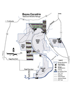
/
enedictine ottoms Wildlife Area he US Army Corps of Engineers purchased the area as a enedictine ottoms Wildlife Area he US Army Corps of Engineers purchased the area as a

enedictine ottoms Wildlife Area he US Army Corps of Engineers purchased the area as a - PDF document

danika-pritchard
danika-pritchard . @danika-pritchard
Follow
538 views
Uploaded On 2015-02-26

enedictine ottoms Wildlife Area he US Army Corps of Engineers purchased the area as a - PPT Presentation

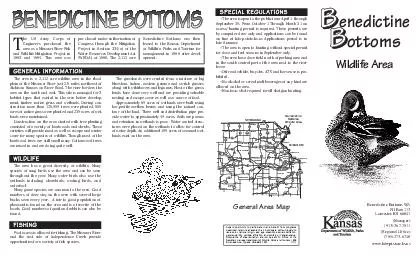
This area was pur chased under authorization of Congress through the Mitigation Project in Section 334a of the Water Resources Development Act WRDA of 1986 The 2112 acre Benedictine Bottoms was then leased to the Kansas Department of Wildlife Parks ID: 39519

This area was pur

Share:

Link:

Embed:

Download Presentation from below link

Download Pdf The PPT/PDF document "enedictine ottoms Wildlife Area he US Ar..." is the property of its rightful owner. Permission is granted to download and print the materials on this web site for personal, non-commercial use only, and to display it on your personal computer provided you do not modify the materials and that you retain all copyright notices contained in the materials. By downloading content from our website, you accept the terms of this agreement.


Presentation Transcript

MISSOURI RIVER Wildlife Area/Public Lands (Primarily Grass)WetlandsTrees/Wooded AreasPaved RoadGravel RoadAuthorized Vehicles Onlye DitchLeveeParkinInformation Center (Area Beyond Closed to Public Vehicles)Well BENEDICTINE BOTTOMSATCHISONSTATE OF MISSOURISTATE OF STATE OF Private Road Independence Creek BBenedictineBBottomsWildlife Area he US Army Corps ofEngineers purchased thearea as a Missouri River Fishand Wildlife Mitigation Project in1993 and 1994. This area waspurchased under authorization ofCongress through the MitigationProject in Section 334(a) of theWater Resources Development Act(WRDA) of 1986. The 2,112 acreBenedictine Bottoms was thenleased to the Kansas Departmentof Wildlife, Parks and Tourism formanagement in 1998 after devel- The area is a 2,112 acre wildlife area in the floodplain of the Missouri River just 2.5 miles northeast ofAtchison Kansas on River Road. The river borders thearea on the south and east. This site is managed for 3habitat types that existed in the area before develop-ment, timber, native grass and wetlands. During con-struction more than 175,000 trees were planted, 550acres of native grass were planted and 230 acres of wet-lands were maintained. Construction on the area started with tree plantingconsisted of a variety of hardwoods and shrubs. Thesevarieties will provide mast as well as escape and wintercover for many species of wildlife. Though most of thehardwood trees are still small many Cottonwood treesare mixed in and are doing quite well. The grasslands were created from a mixture of bigbluestem, Indian, eastern gamma and switch grassesalong with wildflowers and legumes. Most of the grass-lands have done very well and are providing valuablenesting and escape cover as well as a source of food. Approximately 80 acres of wetlands were built usinglow-profile earthen berms and using the natural con-tour of the land. Three well and distribution pipe pro-vide water to approximately 40 acres. Soils are porousand retention in wetlands is poor. Water control struc-tures were placed on the wetlands to allow for controlof water depth. An additional 190 acres of seasonal wet-lands exist on the area. The area has a great diversity of wildlife. Manyspecies of song birds use the area and can be seenthroughout the year. Many water birds also use thewetlands including shorebirds, wading birds, andwaterfowl. Many game species are common to the area. Goodnumbers of deer stay on the area with several largebucks seen every year. A fair to good population ofpheasant is found on the area and is a favorite of thelocals. Good numbers of quail and rabbits can also befound. GENERAL INFORMATION SPECIAL REGULATIONS WILDLIFE GEARYWABAUNSEEPOTTAWATOMIEJACKSONATCHISONBROWNSHAWNEELEAVEN- WORTHOSAGEWYANDOTTE GroveWestmorelandMarysvilleJunctionTopekaLeavenworthAtchisonTroyHiawathaLawrenceLyndonOttawaPaola 8 8 8 8 2 7 8 87 40 Wildlife Area General Area Map Foot access is allowed for fishing. The Missouri Riverand the east side of Independence Creek provideopportunities for a variety of fish species. FISHING The area is open to the public from April 1 throughSeptember 30. From October 1 Through March 31 anaccess/hunting permit is required. These permits areby computer draw only and applications can be foundon line at kdwp.state.ks.us Applications period is inlate Summer.The area is open to hunting without special permitfor dove and teal seasons in September only. The area has a dove field north of parking area andin the south central part of the area next to the riverlevee. Off road vehicle, bicycles, ATV and horse use is pro-hibited. No alcohol or cereal malt beverages of any kind areallowed on the area. Non-toxic shot required for all shotgun hunting. Benedictine Bottoms WAPO Box 113Lancaster, KS 66041(913) 367-7811(Regional Office)(785) 273-6740www.kdwpt.state.ks.us Equal opportunity to participate in and benefit from programsdescribed herein is available to all individuals without regard torace, color, national origin, sex, age, disability, sexual orientation,gender identity, political affiliation, and military or veteran status.Complaints of discrimination should be sent to Office of theSecretary, Kansas Department of Wildlife, Parks and Tourism, 1020S Kansas Ave., Topeka, KS 66612-1327.11/11