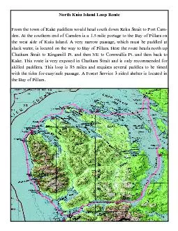
/
the west side of Kuiu Island A very namust be paddled at slack water the west side of Kuiu Island A very namust be paddled at slack water

the west side of Kuiu Island A very namust be paddled at slack water - PDF document

davies
davies . @davies
Follow
345 views
Uploaded On 2021-06-28

the west side of Kuiu Island A very namust be paddled at slack water - PPT Presentation

242322212019181716Bay Campsites and information pages for the Northwest Kuiu paddling loop route Campsite Name Campsite Number Keku 7 16 Keku 4 17 Kingsmill 5 19 Kingsmill 3 ID: 848472

tide port campsite bay port tide bay campsite 146 miles alexander beach map kuiu number water characteristics camden located

Share:

Link:

Embed:

Download Presentation from below link

Download Pdf The PPT/PDF document "the west side of Kuiu Island A very namu..." is the property of its rightful owner. Permission is granted to download and print the materials on this web site for personal, non-commercial use only, and to display it on your personal computer provided you do not modify the materials and that you retain all copyright notices contained in the materials. By downloading content from our website, you accept the terms of this agreement.


Presentation Transcript

1 the west side of Kuiu Island. A very nam
the west side of Kuiu Island. A very namust be paddled at slack water, is located on the way to Bay Kake. This route is very exposed in Chwith the tides for easy/safe passage. A Forest Service 3 sided shelter is located in #24#23#22#21#20#19#18#17#16Bay Campsites and information pages for the Northwest Kuiu paddling loop route Campsite Name Campsite Number Keku 7 #16 Keku 4

2 #17 Kingsmill 5 #19 Kingsmill 3 #2
#17 Kingsmill 5 #19 Kingsmill 3 #20 Port Camden 7 #24 Saginaw 4 #18 Washington Bay 1 #21 Port Camden 1 #23 Bay of Pillars Portage Trail #617Shelter in Bay of Pillars #22 # 16 NW Kuiu Map: Port Alexander D-1 Located on an island in the Keku Island group. It’s the second largest island directly south of Payne Island. The campsite beach faces

3 SW. Cornwallis Point is 5.5 miles to th
SW. Cornwallis Point is 5.5 miles to the NW and Kake is 9 miles to the east. Number of tents: Tide levelBeach Characteristics: Distance to campsite at low tide: Water source: pack it in NMap Port Alexander D-1 # 17 NW Kuiu Map: Port Alexander D-1 W 134-12.450’: Located on the NW corner of Kumiles to the NW. The beach campsite is located behind a small island and fac

4 es to the NE. Kake is 12 miles east acro
es to the NE. Kake is 12 miles east across Keku Strait. Number of tents: Tide level: Beach Characteristics: Distance to campsite at low tide: Water source: small creek nearby NCampsite Map Port Alexander D-1 # 18 NW Kuiu Map: Port Alexander D-1 W 134-19.050’Bay and Security Bay in a small bay. Beach campsite faces NW. Number of tents: Tide level: 15’

5 Beach Characteristics: Distance to camp
Beach Characteristics: Distance to campsite at low tide: Water source: NMap Port Alexander D-1 Kingsmill 5 # 19 NW Kuiu Map: Port Alexander D-2W 134-24.050’Site is 1.4 miles NW of the Kingsmill Pt. Light and 7.3 miles SE of and is a great base camp to explore this area. With a high tide paddlers can check out the Number of tents: Tide level: ( Beach Charact

6 eristics: exposed to north windsDistance
eristics: exposed to north windsDistance to campsite at low tide: Water source: small creek N Kingsmill 3 # 20 NW Kuiu Map: Port Alexander D-2 W 134-23.383’Small cove off of Chatham Strait, 4.2 miles north of Washington Bay and 5.2 miles south of the Kingsmill Light. Beach faces west. Number of tents: Tide level: ’ ( Beach Characteristics: Distance to campsite a

7 t low tide: Water source: Large creek NM
t low tide: Water source: Large creek NMap Port Alexander D-2 Washington Bay 1 # 21 NW Kuiu Map: Port Alexander C-2 W 134-22.416’: Campsite is located on Chatham Straits in a bight one mile south of Washington Bay. Pt Ellis is 10 miles to the south and Kingmill is 13 miles to the north. Campsite faces west for outstanding sunsets! Number of tents: Tide level: 11

8 ’ (Beach Characteristics: Distan
’ (Beach Characteristics: Distance to campsite at low tide: Water source: small creek near by N N N Shelter in Bay of Pillars # 22 NW Kuiu Map: Port Alexander C-1 N 56-35.006’ W 134-16.166’: Very nice three sided shelter on protected bay. This is a free first come, first served Forest Service shelter located about one mile southwest of cannery ruins. It’s 9

9 .1 miles to the Port Camden Portag the p
.1 miles to the Port Camden Portag the portage must be done at slack water. Lots of island to explore in this area. Number of tents: Tide level: 11’ Beach Characteristics: Distance to campsite at low tide: Water small creek near by Map Port Alexander C-1 Bay of Pillars Portage Trail # 617 The trailhead is marked with a large remond markers. From Port Camden, the trato a spur

10 road. At high tide you are able to padd
road. At high tide you are able to paddle close to this road end. Follow the trail to Bay of Pillars. Watch for Blue Diead 1.5 hours before slack Bay of Pillars. Two kayak where the last portagers left them. It’s 3 miles to the narrows. At mid tide the tidal current causes large Port Camden 1 # 23 NW Kuiu Map: Port Alexander C-1 Latitude: Longitude: Located on the

11 Port Camden side old road spur off Fore
Port Camden side old road spur off Forest Service road # 6402. Nice spot with creek and meadow nearby. Note that Port Camden has a very large tide flat so plan to arrive ing on the Bay of Pillars side of the Portage is very poor. existing old road Number of tents: Beach Characteristics: Large tide flatsDistance to campsite at low tide: 3/4 mileWater source: N Port Camden 7

12 # 24 NW Kuiu Map: P-Burg D-6 W 133-5
# 24 NW Kuiu Map: P-Burg D-6 W 133-53.500’: Located 1.5 miles south of Pt. Camden on the east side of Port Cam-den. Large gravel beach. Site faces southwest and is 13.5 miles south of Kake and 13.6 miles north of the Bay of Pillars portage. Number of tents: Tide level: 18’ Beach Characteristics: Distance to campsite at low tide: Water source: small drainage 1/