/
Flight Planning To prepare photography for photogrammetric operations a flight planning Flight Planning To prepare photography for photogrammetric operations a flight planning

Flight Planning To prepare photography for photogrammetric operations a flight planning - PowerPoint Presentation

eleanor
eleanor . @eleanor
Follow
66 views
Uploaded On 2023-06-25

Flight Planning To prepare photography for photogrammetric operations a flight planning - PPT Presentation

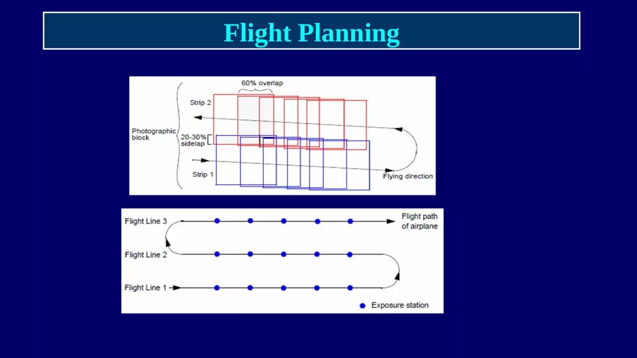
Flight Planning Factors to be discussed in flight planning Selection of photo scale Flight direction Flying Height and Camera focal length Overlap for stereo viewing and complete coverage ID: 1003411

photo flight scale photos flight photo photos scale number area length strip speed height coverage overlap flying strips consecutive

Share:

Link:

Embed:

Download Presentation from below link

Download Presentation The PPT/PDF document "Flight Planning To prepare photography f..." is the property of its rightful owner. Permission is granted to download and print the materials on this web site for personal, non-commercial use only, and to display it on your personal computer provided you do not modify the materials and that you retain all copyright notices contained in the materials. By downloading content from our website, you accept the terms of this agreement.


Presentation Transcript

1. Flight Planning

2. To prepare photography for photogrammetric operations a flight planning is necessary

3. Flight PlanningFactors to be discussed in flight planning:Selection of photo scale:* Flight direction - Flying Height and Camera focal length* Overlap for stereo viewing and complete coverage Forward Overlap 50-80% Side Overlap 15-30%* Number of strips and total number of photos needed to cover an area (BLOCK)

4. Flight PlanningStandard photo dimensions is the squared format 23x23 cmCommonly used camera focal length is 150mm (100mm, 210mm and 300mm are also available)For a plotting instrument of accuracy factor (C-F) of 2000 and CI = 1m; It is recommended to fly at an altitude H = CI x CF = 1m x 2000=2000m or lessFlying height and photo scale will decide required camera focal length, f = H x photo scale

5. Flight PlanningFlying Height – Camera – Photo ScalePhoto scale = f/HA photo of scale 1/10000 can allow ground accuracy of 0.05m if plotter accuracy is 2µmFor this scale flying height should be within 1.5km if a camera of focal length 150mm is available

6. Flight Planning – Flying HeightExample:A camera of focal length 150mm is available, what is the maximum flying height if the scale should not be smaller than 1:8000, CI=1.0m and plotter C-Factor is 1500?From scale and focal length, H < 0.15x8000 < 1200mFrom CI and CF; H < 1.00x1500 < 1500mFlying height should be less or equal to 1200m

7. Flight Planning - Image MotionThis is caused by movement of camera in craft during exposure, affected by camera opening time, craft speed and photo scale Flight Direction

8. Flight PlanningFlight speed, V should also be selected to reduce image motion (IM) on the photo. With slow‐flying aircraft, fast film, and fast shutter speeds (t), IM is frequently not a problem. For a photography flown close to the ground (large scale photo), IM calculation should be made prior to the photo mission so that adjustments for V or t can be made if necessary. We can calculate image movement (IM) in mm using the equation:  IM =  (V) (t) (f / H); V in m/sec; t, shutter speed in sec, H, flying height in m, f, focal length in mm 

9. Flight Speed and Image MotionExample:Compute the maximum craft speed to produce an aerial photo of scale 1:10000, using a shutter of speed 1/1000 sec, if image motion is not to exceed 0.005mmSolution:IM = V t (f/H) = 0.005 = V x (1/1000) x (1/10000)V = (0.005/1000) x 1000 x 10000 = 50 m/sec = 180 km/hrIf flight speed is is 300km/hr, what shutter speed is needed to allow image motion of 0.010mm (photo scale is 1/10000)?t= IM (H/f) / V = 0.010 x 10000 / (300x1000x1000/3600) = 1/833 sec;Use shutter speed 1/1000 sec

10. Overlap

11. Flight runOverlapIn the flight direction, called Forward overlap (FL), should not be less than 60%. Mainly needed for stereo viewing

12.

13. FL

14. Forward Overlap (FL)Forward lap (between consecutive photos in a strip) is usually chosen to be more than 50% (usually 60-70%). If forward lap is 60%, stereo model area (effective model area) will be =(40%L) * L = 0.4 * 2300 * 2300 =2.116 sq.km. (Assuming photo format 23cmx23cm and photo scale1/10000)Distance between consecutive exposure stationsis the air base, B = 0.4 * L =0.4 * 2300 = 920mB/H (Base to Height Ratio) is preferred to be large enough for better stereo viewing and height determination.

15. Forward OverlapDistance between consecutive exposure stations is Base line, B. If format dimension in flight direction is L and FL is 60% then B = 40% of L = 0.4xL. If format is 23x23cm and scale is 1:2000, L=460m and B=184m. Exposures on one line form a strip of photos.

16. Number of Photos in a Strip Number of photos per strip = length of area to be photographed (Q) / distance between consecutive photos (B) + 1:If area to be covered by aerial photos = Q * W =60km * 20km, flight direction better be chosen along longer area dimension (60km). Q=60km; W=20kmNumber of photos per strip = (Q/B) + 1 = (60/0.92) +1 = 65.2 +1, Take 66 + 1 = 67 photosTo assure stereo coverage add two photos on each Side of the strip, hence67 + 4 = 71 photosPer strip

17. Side Overlap (SL)Between each consecutive strips there should be overlap of not less than 15%, usually 30%, called side overlap (SL); distance between consecutive flight lines (G) will be 70% of photo ground coverage (L)

18. Side OverlapOverlap between consecutive strips (side lap) assures complete coverage along width of the area, assumed 25% in this case:

19. Number of StripsSide lap is usually taken more than 20% of width of photo coverageDistance between consecutive flight lines, G = 80% of coverage width = 0.8 * 2300 = 1840m; 2300m is the photo ground coverageIf Area width is 20km, Align first and last flight lines 0.3*2300m (one third of the photo lateral ground coverage) outside the north and south boundary lines to ensure lateral coverage outside the project area. Hence, effective area width, W’=20km + 2x0.3x2.3= 21.38km. Number of strips to cover the area = W’/G + 1= (21.38/1.84) +1 = 11.6 +1 = 13 strips

20. Total Number of PhotosThe total Number of photos to cover the whole area 60kmx20km =Number of photos per strip x number of stripsTotal number of photos required = number of photos per strip x number of strips= 71*13=923 photos. Length of film for one photo = 23cm/scale= 23cm = 0.23mLength of film required=923*0.23= 212.3mA flight plan should be drawn to scale showing positions of exposure stations and flight lines to be used by craft crew

21. Conclusions on Flight Planning RequirementsDetermine photogrammetric specifications in terms of flight height, the number of photographs per strip, the number of strips or (flight lines), approximate locations for exposure stations, and equipment to be used. Specifications should also be developed for ground control and compilation methodology.Verify that the weather conditions are suitable for flying. Flying under conditions of low visibility or potential strong turbulence should be avoided. Bad weather conditions could not only produce unacceptable photographic results, but also risk the flying crew.

22. ExampleDetermine data required to produce photography of scale 1:8000 to produce contour maps of CI=1m, Using Stereo plotter of C-Factor 1800; maximum image motion not more than 0.010mm, to cover an area of dimensions 80km x 30km. Forward and Side laps to be 70% and 20%, respectively, shutter sped (exposure time) 1/1500 secSolution:From C-F and CI; H less than CI x CF, 1.0 x 1800 = 1800mFor scale 1:8000, focal length, f = [1800 / 8000] x 1000 mm = 225mmPhoto ground coverage length= 23x8000/100 =1840mForward Lap = 70%; Air Base, B = 30% of 1840 = 552mNo of photos per strip = (80000/552) +1 = 144.9; take 145 photosFor certainty of long coverage add to photos to each side :Number of photos per strip =145 + 4 =149 photos

23. Example SolutionDistance between flight lines = 80% of ground coverage (1840m) = 0.8x1840 = 1472mNo of flight lines (strips) = (W’/1472) + 1W’ = W + 2x1.84x0.3= 21.104kmNo of strips = (21104/1472) + 1 = 14.3 + 1; take 15 + 1 = 16 stripsTotal No. of photos =149x16 = 2384 photosFilm length = 2384x0.23 =548.32mAir craft flight speed = IM / (t x f/H) = IM x (H/f) / t = [0.01 x 8000x1000/ (1/1500)] m/sec = 120m/sec= 120 x 3600 / 1000 = 432 km/hr=