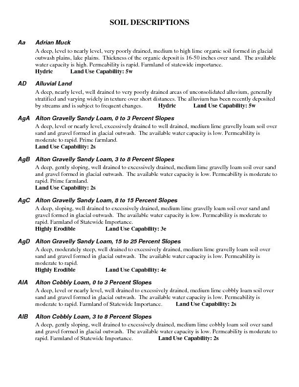
/
SOIL DESCRIPTIONS Aa Adrian Muck  A deep, level to nearly level, very SOIL DESCRIPTIONS Aa Adrian Muck  A deep, level to nearly level, very

SOIL DESCRIPTIONS Aa Adrian Muck A deep, level to nearly level, very - PDF document

ellena-manuel
ellena-manuel . @ellena-manuel
Follow
506 views
Uploaded On 2016-06-10

SOIL DESCRIPTIONS Aa Adrian Muck A deep, level to nearly level, very - PPT Presentation

Ap Appleton Loam 0 to 5 Percent Slopes This is a deep nearly level or gently sloping somewhat poorly drained high lime cobbly loam soil formed in glacial till Available water capacity is modera ID: 355391

Appleton Loam

Share:

Link:

Embed:

Download Presentation from below link

Download Pdf The PPT/PDF document "SOIL DESCRIPTIONS Aa Adrian Muck A deep..." is the property of its rightful owner. Permission is granted to download and print the materials on this web site for personal, non-commercial use only, and to display it on your personal computer provided you do not modify the materials and that you retain all copyright notices contained in the materials. By downloading content from our website, you accept the terms of this agreement.


Presentation Transcript

SOIL DESCRIPTIONS Aa Adrian Muck A deep, level to nearly level, very poorly drained, medium to high lime organic soil formed in glacial water capacity is high. Permeability is rapid. Farmland of statewide importance. Hydric Land Use Capability: 5w AD Alluvial Land A deep, nearly level, well drained to very poorlyated alluvium, generally stances. The alluvium has been recently deposited by streams and is subject to frequent changes. Hydric Land Use Capability: 5w AgA Alton Gravelly Sandy Loam, 0 to 3 Percent Slopes A deep, level or nearly level, excessively drained to well drained, medium lime gravelly loam soil over sand and gravel formed in glacial outwash. The available water capacity is low. Permeability is moderate to rapid. Prime farmland. Land Use Capability: 2s AgB Alton Gravelly Sandy Loam, 3 to 8 Percent Slopes A deep, gently sloping, well drained to excessively drained, medium lime gravelly loam soil over sand and gravel formed in glacial outwash. The available water capacity is low. Permeability is moderate to rapid. Prime farmland. Land Use Capability: 2s AgC Alton Gravelly Sandy Loam, 8 to 15 Percent Slopes A deep, sloping, well drained to excessively drained, medium lime gravelly loam soil over sand and gravel formed in glacial outwash. The available water capacity is low. Permeability is moderate to rapid. Farmland of Statewide Importance. Highly Erodible Land Use Capability: 3e AgD Alton Gravelly Sandy Loam, 15 to 25 Percent Slopes A deep, moderately steep, well drained to excessively drained, medium lime gravelly loam soil over sand and gravel formed in glacial outwash. The available water capacity is low. Permeability is Highly Erodible Land Use Capability: 4e AlA Alton Cobbly Loam, cessively drained, medium lime cobbly loam soil over sand and gravel formed in glacial outwash. The available water capacity is low. Permeability is moderate to rapid. Farmland of Statewide Importance. Land Use Capability: 2sAlB Alton Cobbly Loam, A deep, gently sloping, well drained to excessively drained, medium lime cobbly loam soil over sand and gravel formed in glacial outwash. The available water capacity is low. Permeability is moderate to rapid. Farmland of Statewide Importance. Land Use Capability: 2s Ap Appleton Loam, 0 to 5 Percent Slopes This is a deep, nearly level or gently sloping, somewhat poorly drained, high lime cobbly loam soil formed in glacial till. Available water capacity is moderate to high. Permeability is moderately slow or slow. Prime farmland. Land Use Capability: 3w Be Beaches very low. Permeability is rapid. BoA Bombay Gravelly Fine Sandy Loan, 0 to 3 Percent Slopes A deep, nearly level, well drained, medium to high lime gravelly loam soil formed in glacial till. The available water capacity is moderate to high. Permeability is moderate to slow. Prime farmland. Use Capability: 2wBoB Bombay Gravelly Fine Sandy Loan, 3 to 8 Percent Slopes A deep, gently sloping, moderately well drained, medium to high lime gravelly loam soil formed in glacial till. The available water capacity is moderate to high. Permeability is moderate to slow. Prime farmland. Land Use Capability: 2e BoC Bombay Gravelly Fine Sandy Loan, 8 to 15 Percent Slopes A deep, sloping, moderately well drained, medium to high lime gravelly loam soil formed in glacial till. The available water capacity is moderate to high. Permeability is moderate to slow. Farmland of Statewide Importance. Highly Erodible Land Use Capability: 3e Ca Canandaigua Silt Loam A deep, nearly level, poorly drained and very poorly drained, medium to high lime silty soil formed in lacustrine deposits. The available water capacity is high. Permeability is moderately slow. Farmland of Statewide Importance. Hydric Land Use Capability: 5w Cd Carlisle Muck A deep, level, very poorly drained, medium to high lime organic soil formed on till plains, and lake Permeability is moderately rapid. Prime farmland. Hydric Land Use Capability: 5w CeB Cazenovia Silt Loam, 3 to 8 Percent Slopes A deep, gently sloping, well drained and moderately well drained, medium to high lime, loamy soil formed in reddish brown glacial till. The available water capacity is high. Permeability is slow. Prime farmland. Highly Erodible Land Use Capability: 2e CeC Cazenovia Silt Loam, 8 to 15 Percent Slopes A deep, sloping, well drained and moderately well drained, medium to high lime, loamy soil formed in acity is high. Permeability is slow. Farmland of Statewide Importance. Highly Erodible Land Use Capability: 3e CoA Cazenovia Gravelly Silt Loam, Bedrock Substratum, 0 to 3 % Slopes A deep, level to nearly level, well drained and moderately well drained, medium to high lime, gravelly loam soil formed in reddish brown glacial till thatavailable water capacity is moderate. Permeability is slow. Prime farmland. Land Use Capability: 2w CoB Cazenovia Gravelly Silt Loam, Bedrock Substratum, 2 to 6 % Slopes A deep, gently sloping, well drained and moderately well drained, medium to high lime, gravelly loam soil formed in reddish brown glacial till that is 40 water capacity is moderate. Permeability is slow. Prime farmland. Land Use Capability: 2e Cp Chippeny Muck A deep, level, very poorly drained, medium to high lime organic soil formed on till plains, and lake Permeability is moderately rapid. Prime farmland. Hydric Land Use Capability: 7w CrB Collamer Silt Loam, 2 to 6 Percent Slopes A deep, gently sloping, moderately well drained, medium lime, silty soil formed in lacustrine deposits. The available water capacity is high. Permeability is rapid. Farmland of Statewide Importance. Use Capability: 2e CsA Colonie Loamy Very Fine Sand, 0 to 2 Percent Slopes A deep, level, well drained to excessively drained, low lime, sandy soil formed in glacial outwash. The available water capacity is low. Permeability is rapid. Farmland of Statewide Importance. Use Capability: 1 CsB Colonie Loamy Very Fine Sand, 2 to 6 Percent Slopes d to excessively drained, low lime, sandy soil formed in glacial outwash. The available water capacity is low. Permeability is rapid. Farmland of Statewide Importance. Land Use Capability: 2eCsC Colonie Loamy Very Fine Sand, 6 to 12 Percent Slopes cessively drained, low lime, sandy soil formed in glacial outwash. The available water capacity is low. Permeability is rapid. Highly Erodible Land Use Capability: 3eCsD Colonie Loamy Very Fine A deep, moderately steep, well drained to excessively drained, low lime, sandy soil formed in glacial outwash. The available water capacity is low. Permeability is rapid. Highly Erodible Land Use Capability: 4eCTE Colonia and Dunkirk Soils, Hilly A deep, hilly, well drained and moderately well drained, medium to low lime, sandy and silty soils formed in outwash and lacustrine deposits, dominateday. The available water capacity is low to high. Permeability is rapid to moderately slow. Highly Erodible Land Use Capability: 6e DkB Dunkirk Silt Loam, 2 to 6 Percent Slopes A deep, gently sloping, moderately well drained, medium lime, silty soil formed in lacustrine deposits dominated by silt, very fine sand and clay. The available water capacity is high. Permeability is moderately slow or slow. Prime Farmland. Land Use Capability: 4e DkC3 Dunkirk Silt Loam, 6 to 12 Percent Slopes, Severely Eroded A deep, sloping, moderately well drained, medium lime, silty soil formed in lacustrine deposits that is rmeability is moderately slow or Highly Erodible Land Use Capability: 4e DkD Dunkirk Silt Loam, 12 to 20 Percent Slopes A deep, moderately steep, moderately well-drained, medium lime, silty soil formed lacustrine deposits dominated by silt, very fine sand and clay. The available water capacity is high. Permeability is moderately slow or slow. Highly Erodible Land Use Capability: 4e Ed Edwards Muck A deep, level, very poorly drained, high lime, organic soil formed in outwash plains, and lake plains. r marly substratum. The available water capacity is high. Permeability is moderately rapid in the organic and variable in the marly substratum. Prime farmland. Hydric Land Use Capability: 4w ElA Elnora Loamy Fine Sand, 0 to 2 Percent Slopes A deep, level, moderately well drained, low lime sandy soil formed in lacustrine deposits. The available water capacity is moderate. Permeability is moderately rapid to rapid. Farmland of Statewide Importance. Land Use Capability: 2w ElB Elnora Loamy Fine Sand, 2 to 6 Percent Slopes A deep, gently sloping, moderately well drained, low lime, sandy soil formed in lacustrine deposits. The available water capacity is moderate. Permeability is moderately rapid to rapid. Capability: 2w FaB Farmington Silt Loam, 0 to 8 Percent Slopes A shallow, nearly level to gently sloping, well drained, medium lime, loamy soils formed in till that is 10 to 20 inches thick over limestone bedrock. The available water capacity is low. Permeability is moderate. Farmland of Statewide Importance. Land Use Capability: 3e Fr Fredon Loam A deep, level, somewhat poorly drained, medium lime, loamy soil formed in glacial outwash. The available water capacity is moderate. Permeability is moderate to rapid. Capability: 3w Fw Fresh Water Marsh A deep, level, very poorly drained, marshy areas around ponds or swamps covered dominantly with grasses, cattails, rushes or Hydric Land Use Capability: 8w Ha Halsey Silt Loam, 0 to 3 Percent Slopes A deep, nearly level, very poorly drained, medium lime soil formed in gravelly glacial outwash. The available water capacity is moderate. Permeability is moderate to rapid. Farmland of Statewide Importance. Hydric Land Use Capability: 5w Hm Hamlin Silt Loam, 0 to 3 Percent Slopes A deep, nearly level, well drained, medium lime, loamy soil formed in flood plains. The available water capacity is high. Permeability is moderate. Prime farmland. Land Use Capability: 1HnA Hilton Gravelly Loam, 0 to 3 Percent Slopes A deep, nearly level, moderately well drained, medium lime, loamy soil formed in glacial till. The available water capacity is moderate. Permeability is moderate to slow. Prime farmland. Use Capability: 2w HnB Hilton Gravelly Loam, 3 to 8 Percent Slopes A deep, gently sloping, moderately well drained, medium lime, loamy soil formed in glacial till. The available water capacity is moderate. Permeability is moderate to slow. Prime farmland. Erodible Land Use Capability: 2e HnC Hilton Gravelly Loam, 8 to 15 Percent Slopes A deep, sloping, moderately well drained, medium lime, loamy soil formed in glacial till. The available water capacity is moderate. Permeability is moderate to slow. Farmland ofHighly Erodible Land Use Capability: 3e HoA Hilton Gravelly Loam, Bedrock S A deep, nearly level, moderately well drained, loamy soil formed in glacial till that is 40 to 70 inches thick over bedrock. The available water capacity is moderate. Permeability is moderate to slow. Prime farmland. Land Use Capability: 2w HoB Hilton Gravelly Loam 3 to 8 Percent Slopes A deep, gently sloping, moderately well-drained, loamy soil formed in glacial till that is 40 to 70 inches thick over bedrock. The available water capacity is moderate. Permeability is moderate to slow. Prime farmland. Potentially Highly Erodible Land Use Capability: 2e IrA Ira Gravelly Fine Sandy Loam, 0 to 3 Percent Slopes A deep, nearly level, well drained, low lime, loamy soil formed in glacial till. It has a very firm fragipan at a depth of 20 to 40 inches. The available water capacity is moderate. Permeability is moderate to slow. Prime farmland. Land Use Capability: 2w IrB Ira Gravelly Fine Sandy Loam, 3 to 8 Percent Slopes A deep, gently sloping, well drained, low lime, loamy soil formed in glacial till. It has a very firm ble water capacity is moderate. Permeability is moderate to slow. Prime farmland. Land Use Capability: 2w IrC Ira Gravelly Fine Sandy Loam, 8 to 15 Percent Slopes A deep, sloping, well drained, low lime, loamy soil formed very firm fragipan at a is moderate. Permeability is moderate to slow. Farmland of Statewide Importance. Highly Erodible Land Use Capability: 3e Jo Joliet Loam, 0 to 3 Percent Slopes A shallow, level or nearly level, somewhat poorly drained, low to medium lime, loamy soil formed in till that is 10 to 20 inches thick over bedrock. The available water capacity is low. Permeability is moderate to slow. Farmland of Statewide Importance. Hydric Land Use Capability: 4wJu Junius Loamy Very Fine Sand, 0 to 3 Percent Slopes A deep, level or nearly level, somewhat poorly drained, high lime, sandy soil formed in lake laid deposits. The available water capacity is moderate. Permeability is rapid and Farmland of Statewide Importance. Land Use Capability: 3w LdB Lairdsville and Riga Silty Clay Loams, 2 to 6 Percent Slopes A moderately deep, gently sloping, well drained, medium lime, clayey soil formed in glacial till that is ive gray shale bedrock. The available water capacity is moderate. Permeability is slow. Farmland of Statewide Importance. Highly Erodible Land Use Capability: 2e LdC Lairdsville and Riga Silty Clay Loams A moderately deep, sloping to moderately steep, well drained, medium lime, clayey soil formed in available water capacity is moderate. Permeability is slow. Highly Erodible Land Use Capability: 3e LEE Lairdsville and Riga Silty Clay Loams, Hill A moderately deep, hilly, well drained, medium lime, clayey soil formed inches thick over red and olive gray shale bedrock. The available water capacity is moderate. Permeability is slow. Farmland of Statewide Importance. Highly Erodible Land Use Capability: 4eLk Lakemont Silty Clay Loam, A deep, nearly level, poorly to very poorly drained, medium lime, clayey soil formed in lacustrine The available water capacity is moderate. Permeability is very slow. Farmland of Statewide Importance. Hydric Land Use Capability: 4w Lm Lamson Very Fine Sandy Loam A deep, level or nearly level, poorly to very poorly drained, medium lime, loamy soil over fine sand and very fine sand, formed in lacustrine deposits. ThPermeability is slow to moderate. Farmland of Statewide Importance. Land Use Capability: 5w LoA Lockport and Brockport Silty Clay Loams, 0 to 3 Percent Slops A moderately deep, nearly level, somewhat poorly drained, medium lime, clayey soils formed in loamy shale bedrock. The available water capacity is moderate. Permeability is very slow. Farmland of Statewide Importance. Capability: 3w LoB Lockport and Brockport Silty Clay Loams, 3 to 8 Percent Slops A moderately deep, gently sloping, somewhat poorly drained, medium lime, clayey soils formed in loamy glacial till that is 20 to 40 inches thick over red and olive gray shale bedrock. The available water capacity is moderate. Permeability is very slow. Farmland of Statewide Importance. Capability: 3w Ls Lyons Mucky Silt Loam A deep, level to nearly level, poorly drained, high lime, loamy soil formedwater capacity is moderate to low. Permeability is very slow. Farmland of Statewide Importance.Hydric Land Use Capability: 5w Ly Lyons Very Stony Silt Loam A deep, level to nearly level, poorly drained, high lime, loamy soil formedavailable water capacity is moderate to low. Permeability is slow to very slow. Hydric Land Use Capability: 7s Ma Madalin Silty Clay Loam A deep, level, poorly drained, high lime, clayey soil formed in lacustrine deposits. The available water capacity is moderate. Permeability is slow to very slow. Hydric Land Use Capability: 4w MdB Madrid Gravelly Fine Sandy Loam, 2 to 8 Percent Slopes A deep, gently sloping, well-drained, medium lime, loamy soil formed in glacial till. The available water capacity is high. Permeability is moderate. Prime farmland. Highly Erodible Land Use Capability: 2e MdC Madrid Gravelly Fine Sandy Loam, 8 to 15 Percent Slopes A deep, sloping, well-drained, medium lime, loamy soil formed in glacial till. The available water capacity is high. Permeability is moderate. Farmland of Statewide Importance. Highly Erodible Land Use Capability: 3e MdD Madrid Gravelly Fine Sandy Loam, 15 to 25 Percent Slopes A deep, moderately steep, well drained, medium lime, loamy soil formed in glacial till. The available water capacity is high. Permeability is moderate. Highly Erodible Land Use Capability: 4e Me Martisco Muck A deep, nearly level, very poorly drained, high lime, silty soil formed in lacustrine deposits, that is 8 to 16 inches thick of organic material over silty marl. The available water capacity is moderate to high. Permeability is moderately slow to slow. Farmland of Statewide Importance. Hydric Land Use Capability: 5w MfA Massena Gravelly Loam, 0 to 3 Percent Slopes A deep, nearly level, somewhat poorly drained, medium lime, loamy soil formed in glacial till. The available water capacity is moderate to low. Permeability is slow. Prime farmland. Hydric Land Use Capability: 3w MfB Massena Gravelly Loam, 3 to 8 Percent Slopes A deep, gently sloping, somewhat poorly drained, medium lime, loamy soil formed in glacial till. The available water capacity is moderate to low. Permeability is slow. Prime farmland. Hydric Land Use Capability: 3w Mg Massena Very Stony Loam, 0 to 3 Percent Slopes A deep, nearly level, somewhat poorly drained, medium lime, loamy soil formed in very stony glacial till. The available water capacity is moderate to low. Permeability is slow. Hydric Land Use Capability: 5s Mn Minoa Very Fine Sandy Loam, 0 to 3 Percent Slopes A deep, nearly level, somewhat poorly drained, medium lime, loamy soil over loamy very fine sand formed in lacustrine deposits. The available water capacity is moderate. Permeability is moderate. Prime farmland.Land Use Capability: 3w Ne Newstead Gravelly Fine Sandy Loam, 0 to 3 Percent Slopes A moderately deep, level or nearly level, somewhat poorly to poorly drained, high loamy soil formed in es over limestone bedrock. The available water capacity is moderate to low. Permeability is moderate. Farmland of Statewide Importance. Land Use Capability: 3w Ng Niagara Silt Loam, 0 to 3 Percent Slopes A deep, level or nearly level, somewhat poorly drained, medium lime, silty soil formed in lacustrine deposits. The available water capacity is high. Permeability is moderately slow. Capability: 3w OaB Oakville Loamy Fine Sand, 0 to 6 Percent Slopes A deep, nearly level to gently sloping, well drained, low lime, sandy soil formed in glacial outwash deposits. The available water capacity is low. Permeability is moderately rapid. Prime farmland. Land Use Capability: 2s OnB Ontario Gravelly Loam, 3 to 8 Percent Slopes A deep, gently sloping, well-drained, medium to high lime, loamy soil formed in glacial till. The available water capacity is moderate. Permeability is moderate to slow. Farmland of Statewide Importance.Highly Erodible Land Use Capability: 2e OnC Ontario Gravelly Loam,A deep, sloping, well-drained, medium to high lime, loamy soil formed in glacial till. The available water capacity is moderate. Permeability is moderate to slow. Farmland of Statewide Importance.Highly Erodible Land Use Capability: 3e OnD Ontario Gravelly Loam, 15 to 25 Percent Slopes A deep, steep, well-drained, medium to high lime, loamy soil formed in glacial till. The available water capacity is moderate. Permeability is moderate to slow. Highly Erodible Land Use Capability: 4e OSE Ontario Soils, Steep A deep, steep, well-drained, medium to high lime, loamy soil formed in glacial till. The available water capacity is moderate. Permeability is moderate to slow. Highly Erodible Land Use Capability: 6e OvA Ovid Silt Loam, 0 to 3 Percent Slopes A deep, nearly level, somewhat poorly drained to moderately well drained, medium lime, loamy soil formed in reddish glacial till. The available water capacity is high. Permeability is slow. Prime farmland. Land Use Capability: 3w OvB Ovid Silt Loam, 3 to 8 Percent Slopes A deep, gently sloping, somewhat poorly drained to moderately well drained, medium lime, loamy soil formed in reddish glacial till. The available water capacity is high. Permeability is slow. Prime farmland. Land Use Capability: 3wPa Palms Muck A deep, nearly level, very poorly drained, medium to high lime, organic soil formed in till plains and nic deposit is 16 to 51 inches over loamy mineral material. The available water capacity is high. Permeability is moderate. Farmland of Statewide Importance. Hydric Land Use Capability: 5wPcA Palmyra Gravelly Loam, 0 to 1 Percent Slopes to excessively well drained, high lime, loamy soil formed in gravelly glacial outwash. The available water capacity is moderate. Permeability is moderate. Prime farmland. Land Use Capability: 1PcB Palmyra Gravelly Loam, 3 to 8 Percent Slopes ned to excessively well drained, high lime, loamy soil formed in gravelly glacial outwash. The available water capacity is moderate. Permeability is moderate. Prime farmland. Highly Erodible Land Use Capability: 2ePcC Palmyra Gravelly Loam, 8 to 15 Percent Slopes cessively well drained, high lime, loamy soil formed in gravelly glacial outwash. The available water capacity is moderate. Permeability is moderate. Farmland of Statewide Importance. Highly Erodible Land Use Capability: 3ePgA Palmyra Cobbly Loam, 0 to 3 Percent Slopes well drained, high lime, loamy soil formed in cobbly glacial outwash. The available water capacity is moderate. Permeability is moderate. Farmland of Statewide Importance. Land Use Capability: 1PgB Palmyra Cobbly Loam, 3 to 8 Percent Slopes d to excessively well drained, high lime, loamy soil formed in cobbly glacial outwash. The available water capacity is moderate. Permeability is moderate. Farmland of Statewide Importance. Highly Erodible Land Use Capability: 2ePhD Palmyra Soils, 15 to 25 Percent Slopes A deep, moderately steep, well drained to excessively well drained, high lime, loamy soil formed in is moderate. Permeability is moderate. Farmland of Statewide Importance. Highly Erodible Land Use Capability: 4e PLE Palmyra and Alton Soils, Steep ned, medium to high lime, loamy soil formed in is moderate. Permeability is Highly Erodible Land Use Capability: 6e PoA Phelps Gravelly Loam, 0 to 3 Percent Slopes A deep, nearly level, moderately well drained, high lime, loamy soil formed in gravelly glacial outwash. The available water capacity is low to moderate. Permeability is moderate to rapid. Prime Farmland.Land Use Capability: 2w PoB Phelps Gravelly Loam, 3 to 8 Percent Slopes well drained, high lime, loamy soil formed in gravelly glacial outwash. The available water capacity is low to moderate. Permeability is moderate to rapid. Prime Farmland. Land Use Capability: 2ePpA Phelps Cobbly Loam, 0 to 3 Percent Slopes A deep, nearly level, moderately well drained, high lime, loamy soil formed in cobbly glacial outwash. The available water capacity is low to moderate. Permeability is moderate to rapid. Farmland of Statewide Importance. Land Use Capability: 2wRaA Rhinebeck Silty Clay Loam, 0 to 3 Percent Slopes A deep, level or nearly level, somewhat poorly drained, medium to high lime, loamy soil formed in lacustrine sediments. The available water capacity is moderate. Permeability is slow. Farmland of Statewide Importance. Land Use Capability: 3w RaB Rhinebeck Silty Clay Loam, 2 to 5 Percent Slopes A deep, gently sloping, somewhat poorly drained, medium to high lime, loamy soil formed in lacustrine sediments. The available water capacity is moderate. Permeability is slow. Farmland of Statewide Importance. Land Use Capability: 3w SdB Sodus Gravelly Fine Sandy Loam, 3 to 8 Percent Slopes A deep, gently sloping, well drained, low lime, loamy soil formed in glacial till. It has very firm fragipan at a depth of 15 to 24 inches. The available water capacity is moderate. Permeability is moderate to slow. Farmland of Statewide Importance. Land Use Capability: 2e SdC Sodus Gravelly Fine Sandy A deep, sloping, well drained, low lime, loamy soil formed in glacial till. It has very firm fragipan at a is moderate. Permeability is moderate to slow. Farmland of Statewide Importance. Highly Erodible Land Use Capability: 3e SdD Sodus Gravelly Fine Sandy A deep, moderately steep, well drained, low lime, loamy soil formed in glacial till. It has a very firm ble water capacity is moderate. Permeability is Highly Erodible Land Use Capability: 4e SSE Sodus Soils, Steep A deep, steep, well drained, low lime, loamy soil formed in glacial till. It has a very firm fragipan at a moderate. Permeability is moderate to slow. Highly Erodible Land Use Capability: 6e Te Teel Silt Loam, A deep, level or nearly level, moderately well drained to somewhat poorly drained, medium to high lime, loamy soil formed on flood plains. The available water capacity is high. Permeability is moderate. Prime Farmland.Land Use Capability: 2w Wa Wallington Silt Loam, 0 to 2 Percent Slopes A deep, nearly level, somewhat poorly drained, low lime, loamy soil high in silts and very fine sands formed in lacustrine deposits. It has a very firm water capacity is moderate. Permeability is moderate to slow. Prime farmland. Capability: 3w WcA Wassic Silt Loam, 0 to 3 Percent Slopes A moderately deep, nearly level, well to moderately well drained, high lime, loamy soil formed in ches thick over limestone bedrock. moderate. Permeability is moderate. Farmland of Statewide Importance. Land Use Capability: 2s WcB Wassic Silt Loam, 3 to 8 Percent Slopes A moderately deep, gently sloping, well to moderately well drained, high lime, loamy soil formed in ches thick over limestone bedrock. moderate. Permeability is moderate. Farmland of Statewide Importance. Highly Erodible Land Use Capability: 2e Wd Wayland Silt Loam, 0 to 3 Percent Slopes A deep, level or nearly level, poorly drained to very poorly drained, medium lime, loamy soil formed on is moderate. Permeability is slow. Hydric Land Use Capability: 5w WnA Williamson Silt Loam, 0 to 2 Percent Slopes A deep, level, well drained, low lime, loamy soil formed sand. It has a very firm fragipan at ble water capacity is moderate. Permeability is slow. Prime farmland. Land Use Capability: 2wWnB Williamson Silt Loam, 2 to 6 Percent Slopes well drained, low lime, loamy soil formed in lacustrine deposits high a very firm fragipan at a depth ofcapacity is moderate. Permeability is slow. Prime farmland. Highly ErodibleCapability: 2eWnC Williamson Silt Loam,A deep, sloping, moderately well drained, low lime, loamy soil formed in lacustrine deposits high in silts and very fine sand. It has a very firm fragipan at a is moderate. Permeability is slow. Farmland of Statewide Importance. Highly ErodibleLand Use Capability: 3e