PDF-TROPICAL CYCLONE DAY OUTLOOK Equator to S and E to W
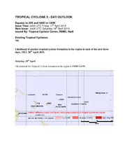
Next Issue 0400 UTC Saturday 18 th April 2015 Issued By Tropical Cyclone Centre RSMC Nadi Existing Tropical Cyclones Nil Likelihood of another tropical cyclone formation
Download Presentation
"TROPICAL CYCLONE DAY OUTLOOK Equator to S and E to W" is the property of its rightful owner. Permission is granted to download and print materials on this website for personal, non-commercial use only, provided you retain all copyright notices. By downloading content from our website, you accept the terms of this agreement.
Presentation Transcript
Transcript not available.