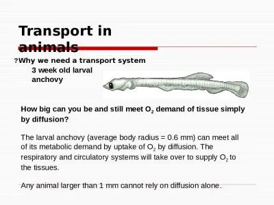
/
Environmental impact evaluation in transport Environmental impact evaluation in transport

Environmental impact evaluation in transport - PowerPoint Presentation

liane-varnes
liane-varnes . @liane-varnes
Follow
382 views
Uploaded On 2018-02-25

Environmental impact evaluation in transport - PPT Presentation

Harun Dogo Environmental Economist Environment and Natural Resources World Bank July 18 2017 Transport projects have diverse environmental effects Effects of transport projects on land resources ID: 635371

air pollution impacts data pollution air data impacts water impact quality resources monitoring effects areas transport assessment environmental land

Share:

Link:

Embed:

Download Presentation from below link

Download Presentation The PPT/PDF document "Environmental impact evaluation in trans..." is the property of its rightful owner. Permission is granted to download and print the materials on this web site for personal, non-commercial use only, and to display it on your personal computer provided you do not modify the materials and that you retain all copyright notices contained in the materials. By downloading content from our website, you accept the terms of this agreement.


Presentation Transcript

Slide1

Environmental impact evaluation in transport

Harun Dogo

Environmental Economist

Environment and Natural Resources, World Bank

July 18, 2017Slide2

Transport projects have diverse environmental effectsSlide3

Effects of transport projects on land resources

Direct:

Land use change

Forest conversion

Habitat fragmentation

Indirect:

Sprawl

Loss of natural capital

Reduction in ecosystem servicesCumulative:Reduced carbon sequestration (climate change)

See Rodrigue (2017) for further description of impacts

Effect of Road Quality on Forest Clearing Intensity

(Barra et al., 2016)Slide4

Data and monitoring for land resource impacts

Data

type

Collection method

Benefits

Challenges

Tree cover/land feature recognition

high-resolution remote sensed image processing

Conducted remotely, cover large areas

Can be expensive to purchase/process high-resolution imageryGround

monitored dataOn-the-ground monitoring by individuals

C

apture nuance that remote sensing cannot

Impractical for large impact areas, conflict zones, etc.Aerial imageryImage collection from airplanes or dronesLess labor-intensive than ground monitoring, but still local engagementRequires both local data collection and image processing

White dots indicate detected oil palm trees in remotely sensed imagery (CRISP, 2001)

Soil sampling can determine contaminants/VOCs

Drone imagery can target specific areas/resources to monitorSlide5

Assessment of land resource impacts

Example

: Estimation of road effects on forest cover

and biodiversity indicators in the DRC combine to simulate effects of transport policy implementation (Barra et al., 2016)

Hotspot analysis:

show overlapping impacts of transport development with cities, biodiversity, economic opportunities, etc.

Cost-benefit analysis

: value of natural capital x extent of impact = significance of impact

Example: Parallel assessment of feasible project options in Botswana including environmental impact costs (Botswana Ministry of Works, Transport & Communications, 2001)Slide6

Effects of transport projects on air quality

Indirect:

Respiratory and cardiovascular problems

Direct:

Noise

Local pollution (particulate matter, carbon monoxide)

Cumulative:

Greenhouse gas effects (climate change)

Deaths from Ambient Air Pollution (OECD, 2014)Slide7

Data and Monitoring for Air Quality Impacts

Data

type

Collection method

Benefits

Challenges

Remote

ly sensed particulate matter data

Processed satellite images

Free, open global sources available

Modeled surfaces mean some inaccuracy

Ground monitored chemical/noise data

Ground air monitoring stations, blood testing, noise monitoring tools

Greater local accuracyExpensive, difficult to implementCO2 concentrations

Processed satellite images/ground monitoring or modeled estimation of impact

Climate change impacts taken into account

Longer-term, dispersed effects mean difficult to monitor locally – estimating impacts with general models can also be inaccurate

Atmospheric CO2 monitoring (NOAA, 2017)

Blood tests can reveal human exposure to harmful substances like lead

Noise pollution monitorSlide8

Assessment of air quality impacts

Need to consider current/future traffic loads, fuel types, exposure, etc.

National/international assessment tools and frameworks:

WHO

AirQ

+ software tool for health risk assessment of air pollution

US Environmental Protection Agency Integrated Science Assessments

Ananberg

et al. (2016) assess 12 multinational air pollution health impact assessment tools

Approach for evaluation of mortality and morbidity from road traffic-related air pollution in Austria, France, and Switzerland (Sommer et al., 2000)Slide9

Effects of transport projects on water resources

Direct:

Water pollution from runoff

Habitat fragmentation

Fuel spills

Dredging

Indirect:

Groundwater contamination

Air pollution falloutInvasive species transferCumulative:Long-term water quality decline

For more information, see US DOT (2002), World Wildlife Fund (2017) and Rodrigue (2017)

Satellite imagery shows “ship tracks” of elevated NO2 levels from shipping pollution (NASA, 2012)Slide10

Data and Monitoring for Water Resource Impacts

Data

type

Collection method

Benefits

Challenges

Remotely sensed water pollution/ temperature

Satellite imagery processing

Global, open source data available

Modeled surface, may not be frequently updated or high enough resolution to show project impact

Water quality levels

Local testing

Fine-scale, targeted water quality data

Difficult to isolate effects of project Water quality test instrumentsSlide11

Assessment of water resource impacts

Hydrologic impact modeling

Valuation of costs

Ecosystem service valuation (value of ecosystems to humans)

Hedonic pricing (isolating environmental value based on willingness-to-pay)

Land cover classification to determine connected pavement for hydrologic modeling

(

Janke

& Gulliver, 2011)

Tracking ecosystem services (erosion control, nutrients in drinking water, carbon storage) redistribution from road development and mitigation in the Amazon(Mandle et al., 2011)

Pucallpa-Cruzeiro do Sul road, PeruSlide12

Thank you!Slide13

Useful Resources for More Information

Rodrigue

, J-P (2017). The Environmental Impacts of Transportation.

https://people.hofstra.edu/geotrans/eng/ch8en/conc8en/ch8c1en.html

Anenberg

, Susan C., Anna

Belova

,

Jørgen Brandt, Neal Fann, Sue Greco, Sarath Guttikunda, Marie-Eve Heroux, et al. 2016. “Survey of Ambient Air Pollution Health Risk Assessment Tools.” Risk Analysis 36 (9): 1718–36. doi:10.1111/risa.12540.Slide14

Data sources for land resources

Indicators

Country Coverage

Database/Source

Forest coverage and loss

Global

Hansen et al., 2013

Soil degradation

Naipal 2015

Vegetation Index (NDVI);

Net Primary Productivity (NPP)

NEO (MODIS/Terra)

Biodiversity

Biodiversity Hot Spots (2011): IBAT and Conservation International

Bird areas

Endemics Bird Areas (1987-1998): IBAT

Protected areas

70 countries

Protected Areas (2014): World Database on Protected Areas (WDPA) (April 2014)Slide15

Data sources for air quality

Indicators

Country Coverage

Database/Source

PM2.5 air pollution, satellite

Global

CIESIN, 2015

PM2.5 air pollution, all

and

dust/salt-removed

van Donkelaar et al., 2016

PM2.5 air pollution, emissions

ECCAD

PM10 air pollution

Black Carbon

NO x

Mercury Slide16

Data sources for water resources

Indicators

Country Coverage

Source

Area of district's shoreline by low, medium, high & very high threat

70 countries

Reefs at Risk (REEF)

database,

World Resources Institute (WRI), 2011

Ocean Health Index/Cumulative Impact Score, fertilization,

pesticides, pollution, night lights, fishing, sea surface temperature, UV, ocean acidification, sea level rise, ocean shipping, invasive species, ocean pollution pressure, oil rigs

Global

Degradation of Marine Ecosystems (COAST),

Halpern et al (2015)

Climate Change Sea Level Trend (SLT)

Nicholls and

Cazenave

Freshwater withdrawal, irrigation, precipitation,

runoff, etc.

Aqueduct

Database,

World Resources Institute (WRI)