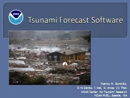
Nancy N Soreide DW Denbo Y Wei D Arcas VV Titov NOAA Center for Tsunami Research NOAA PMEL Seattle WA NOAA Center for Tsunami Research Chile tsunami event Feb 27 2010 YouTube video embedded in slide ID: 427343
Download Presentation The PPT/PDF document "Tsunami Forecast Software" is the property of its rightful owner. Permission is granted to download and print the materials on this web site for personal, non-commercial use only, and to display it on your personal computer provided you do not modify the materials and that you retain all copyright notices contained in the materials. By downloading content from our website, you accept the terms of this agreement.
Slide1
Tsunami Forecast Software
Nancy N. Soreide, D.W. Denbo, Y. Wei, D. Arcas, V.V. TitovNOAA Center for Tsunami ResearchNOAA PMEL, Seattle, WASlide2
NOAA Center for Tsunami Research
Chile tsunami event (Feb 27, 2010)
YouTube video embedded in slide
… or play from
YouTube
or local video file
2Slide3
Overview of Tsunami Forecasting
NOAA Center for Tsunami Research3
Earthquake!
Data network
Model & data assimilation
Tsunami forecast guidanceSlide4
5
6
7
8
9
10
-4
-3
-2
-1
0
1
2
3
4
5
Courtesy V.K.
Gusiakov
Earthquake Magnitude
Tsunami Intensity
4
The intensity of the earthquake alone does not predict the size of a tsunami
… or even if a tsunami will occur.Slide5
Tsunami detection buoys
DART® tsunami buoys measure the size of a tsunami, in the open ocean, before it comes ashore
5Slide6
DART® Buoys are strategically located throughout the ocean
Real-time, high resolution buoy data is used to refine the forecast - while the tsunami is still propagating through the ocean.
DART®
Earthquake
6Slide7
Combines
Earthquake seismic informationReal-time tsunami buoy measurements in the deep oceanComputer models to predict tsunami propagation and coastal floodingProvidesReal-time tsunami propagation forecastsReal-time coastal flooding forecasts* Installed at the NOAA Tsunami Warning Centers in Alaska and Hawaii
NOAA Center for Tsunami Research7
NOAA Tsunami Forecast software
* For selected coastal communitiesSlide8
Tsunami propagation is pre-computed
for Unit Sources along global coastlines Unit earthquake source locations are co-located with earthquake locations
8
NOAA Center for Tsunami ResearchSlide9
DART® data is assimilated into the model to refine the forecast
NOAA Center for Tsunami Research9Slide10
Real-time Coastal Flooding Forecasts
for selected coastal communitiesNOAA Center for Tsunami Research
10Slide11
Future forecast productAreas of flooding & Harbor currents
11
NOAA Center for Tsunami ResearchSlide12
http://nctr.pmel.noaa.gov
NOAA Center for Tsunami ResearchLocated at NOAA PMEL in Seattle, WA12
Maximum tsunami amplitude
Chile tsunami February 27, 2010Slide13
BACKUP SLIDES
13NOAA Center for Tsunami ResearchSlide14
NOAA Center for Tsunami Research
Chile tsunami event (Feb 27, 2010)
Video & Media Player embedded in slide
… or play from
YouTube
or local video file
14