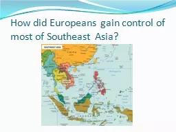
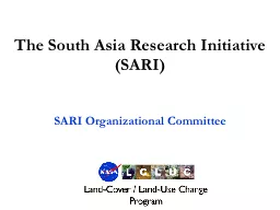
Update Krishna Prasad Vadrevu NASA MSFC Background to the SARI initiative Regional science issues from the SARI meetings 20152016 SARI next steps Presentation topics How it started strong interest in a SARI from local scientists ID: 800081
Download The PPT/PDF document "The South/Southeast Asia Research Init..." is the property of its rightful owner. Permission is granted to download and print the materials on this web site for personal, non-commercial use only, and to display it on your personal computer provided you do not modify the materials and that you retain all copyright notices contained in the materials. By downloading content from our website, you accept the terms of this agreement.
Slide1
The South/Southeast Asia Research Initiative (SARI) Update
Krishna Prasad VadrevuNASA MSFC
Slide2Background to the SARI initiative Regional science issues from the
SARI meetings (2015-2016)SARI next steps
Presentation topics
Slide3How it started - strong interest in a SARI from local scientists
Jan-10-13th, 2013-Regional Science Meeting, Coimbatore
Total participants =120US – 18 researchersNepal-3; Srilanka-2; Myanmar-1; Afghanistan, Myanmar, Bangladesh-1 eachPakistan, China invited but could not attend – Visa issuesIndia – University Researchers, Government, Non-Government, NGO’s
Slide4Meeting Summary-The Earth ObserverMarch/April 2013
http://eospso.gsfc.nasa.gov/eos_homepage/for_scientists/earth_observer.php
Slide5Agricultural land use in South/SE Asia
Significant increase in Agricultural Land Area (x 1000ha) in Several South and Southeast Asian Countries
Data Source: FAO, 2015Vadrevu et al., 2017, ERL (in press)
Slide6Forest Area in South/SE Asia
Significant decrease in Forest
Area (x 1000ha) in Several South and Southeast Asian CountriesData Source: FAO, 2015Vadrevu et al., 2015, ERL (in Press)
Slide7SARI - GoalTo
develop an innovative research, education, and capacity building program involving state-of-the-art remote sensing, natural sciences, engineering and social sciences to enrich LCLUC science in South/Southeast Asia.
Slide8Regional Science Issues – Inputs from SARI Workshops
Slide9SARI meetings - funded by NIES, Japan and several other international, regional and local partners
Slide10ForestsSpatiotemporal Drivers of Fine-Scale Forest Plantation Establishment in Village-Based Economies of Andhra Pradesh
Consequences of Changing Mangrove Forests in South Asia on the Provision of Global Ecosystem Goods and ServicesComplex Forest Landscapes and Sociopolitical Drivers of Deforestation - The Interplay of Land-use Policies, Armed Conflict, and Human Displacement in
MyanmarImpacts of Afforestation on Sustainable Livelihoods in Rural Communities in IndiaTropical Deciduous Forests of South Asia: Monitoring Degradation and Assessing Impacts of Urbanization2015-2016 LCLUC South Asia Projects
Slide11Agriculture and Food security Landscapes In Flux: The Influence of Demographic Change and Institutional Mechanisms on Land Cover Change, Climate Adaptability and Food Security in Rural India
The Future of Food Security in India: Can Farmers Adapt to Environmental Change?Understanding Changes in Agricultural Land Use and Land Cover in the Breadbasket Area of the Ganges Basin 2000-2015: A Socioeconomic-Ecological Analysis
UrbanUrban Growth, Land-Use Change, and Growing Vulnerability in the Greater Himalaya Mountain Range Across India, Nepal, and Bhutan Human HealthUnderstanding the Role of Land Cover/Land Use Nexus in Malaria Transmission Under Changing Socio-Economic Climate in Myanmar 2015-2016 LCLUC South Asia Projects
Slide12Agriculture Long- term Food Security is a major concern for the region;
Agricultural production and land use is changing Crop water requirements; Extreme events (flooding and drought (almost every year!)Adaptation options needs to be explored to address food security questions RS data needed to monitor agriculture (within season) and forecast crop production (integrating Landsat+ Sentinel + other high resolution data);
Transitioning from research to operational research3-year research projects (eg: 6-different teams working on Rice mapping in Mekong; coordination required and transitioning from research to operations; Crop type and area statisticsProduction estimatesYield forecastingGEOGLAM working on some of the above activities.
Slide13Water Resources Water management policies and systems need to be enhanced to accommodate the current and future trends (extreme events, limited flow, ground water management)
Shortage of freshwater because of urbanization, agriculture and aquaculture; Nutrient and pesticide residue issues need attention;Inconsistent data at national and regional data on water resources; Upstream countries need to share data more effectively;
Data on water quantity and water quality including sediment transport; subsidence, change of water bodies (RS for mapping/monitoring); Need for more detailed at temporal scale on water resource datasets; Science results need to be communicated to decision makers.
Slide14Urban EnvironmentsRapid Urban Change in this region including mega cities - some planning
But largely uncontrolled development and industrial infrastructure– displacing rural communitiesTraffic and pollution unprecedented – with human health impacts;How infrastructure can cope up with the sewage/drainage/flooding related issues); Urban development tied to health/diseases – thus need attention; Need for timely monitoring and transparency (satellite based approaches still not robust!)
Need for land zoning to update land records; Comprehensive urban planning is a challenge but very much needed.
Slide15Emissions Inventories and GHG’s Policy mandate – national contribution (Intended Naturally Determined Contributions (INDC’s) – MRV;
Underlying data sets still in development especially w.r.t AFOLU – forestry and agriculture (inventory) (eg: Cambodia almost no GHG data); Vietnam no standardized methodologies;)Need for enhanced national GHG monitoring systemsUsing Instrumentation and integrating satellite remote sensing data;Robust methodologies to develop spatially explicit GHG inventories;
Emissions data linking with public health.Need a closer partnership with policy formulation community to inform the policy development; Training on GHG inventory expertise is needed for the country; Need for capacity building and training in air pollution inventory methodologies.
Slide16Data and AnalysisMany Data Management Challenges (many countries yet to develop Spatial Data Infrastructure (SDI)
Need for adequate funding and Efficiencies can be made at the national level (data stewardship) Cloud computing and Private Clouds offer an opportunity – IT/Science partnerships Priority for high resolution datasets; time series analysis at large spatial scales in LCLUC;Metadata is poor (data quality is always questionable);
Need authentic data (to be approved by Govt; otherwise, it becomes to difficult to convince the results); Data transfer/sharing mechanisms;.Transitioning the data to users in a useful manner is very important (eg: SERVIR application projects; GEOGLAM crop monitor;)
Slide17Involving National Researchers and Practitioners – Universities, Institutes and Operational Agencies;Strong emphasis on Applied Research with regional / national societal applications and benefits.Facilitate strengthening regional/national projects through co-design and collaborations;
SARI Priority
Slide18Collaborations are the
Key !
Slide19October, 2017
Total Meeting Participants =140Training Participants = 903-Day Meeting
3-Day Trainingincluding tea/coffee breaks + lunches
Slide20Ho Chi Minh City University of TechnologyVietnam National University-Ho Chi Minh City
22-different institution contribution
22 different institutions/programs – Collaborations are the key to success !
Slide21Volume-I
Volume-II
SARI - Peer Reviewed Publications
Slide22SARI Outputs-2015-2016-2017 (in just 2.5 years)
SARI Peer Reviewed Publications: 102NASA LCLUC South Asia projects just started (March-1, 20177)
Slide23Landsat images for the whole country of Myanmar
Images
from Landsat 8 for the period of January-March, 2015. LANDSAT-8 – 2015 – CLOUD FREE IMAGESFREE LANDSAT-8 DATA
Slide24Dates: May 2-4 2017Venue: GGIndraprastha
University, New DelhiTotal participants: 80TopicsRemote sensing of agriculture i.e., crop identification and crop phenology/growth mapping/monitoring, yield estimation/prediction, key biophysical, biochemical and environmental parameters governing crop production, crop damage/disaster monitoring, precision farming, crop residue management,
etc.
Slide25http://explore.tandfonline.com/cfp/est/tres-remote-sensing-in-asia-cfp
Deadline: December 31st, 2017Eds: Krishna Vadrevu, Vinay Dadhwal, Garik
Gutman and Chris Justice
Slide262017 – Operational Mapping/Monitoring of Agricultural crops in South/Southeast Asia
Meeting Focus: Agriculture Dates: May 2-4th, 20172017 - SARI LCLUC regional meeting in Thailand
Meeting: July 17-18-19Training: July 20-21-222018 - LCLUC and Emissions Meeting in LaosDates: TBDTraining2018 - LCLUC in Mountain Environments, BhutanDates: TBDTrainingSARI forthcoming meetings (2017-2018)
Slide27Dates: July 17-19th, 2017
Venue: Chiang Mai, Thailand.Training: 20-22nd, 2017Themes: LCLUC relating to (1) agriculture and water resources, 2) biomass burning, including land-atmosphere interactions, 3) urbanization, and 4) land use in coastal zones and estuaries, and 5) land use in forests and mountain regions
www.lcluc.umd.edu
Slide28SARI website www.sari.umd.edu