/
Estuary Environments Salmon River/ Estuary Environments Salmon River/

Estuary Environments Salmon River/ - PowerPoint Presentation

olivia-moreira
olivia-moreira . @olivia-moreira
Follow
346 views
Uploaded On 2018-10-06

Estuary Environments Salmon River/ - PPT Presentation

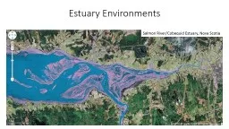
Cobequid Estuary Nova Scotia Landward limit of tidal facies Seaward limit of fluvial influence Estuary a coastal embayment with mixed marinefluvial influence Estuaries have retrogradational ID: 685714

estuary tidal firm ravinement tidal estuary ravinement firm surface sediment transgressive bedding beds marine wave seaward fluvial surfaces setting

Share:

Link:

Embed:

Download Presentation from below link

Download Presentation The PPT/PDF document "Estuary Environments Salmon River/" is the property of its rightful owner. Permission is granted to download and print the materials on this web site for personal, non-commercial use only, and to display it on your personal computer provided you do not modify the materials and that you retain all copyright notices contained in the materials. By downloading content from our website, you accept the terms of this agreement.


Presentation Transcript

Slide1

Estuary Environments

Salmon River/

Cobequid

Estuary, Nova ScotiaSlide2

Landward limit of tidal

facies

Seaward limit of fluvial influence

Estuary: a coastal

embayment with mixed marine/fluvial influence

Estuaries have

retrogradational

facies

stacking pattern (form during transgression); deltas prograde and form during regressionSlide3

Tide-Dominated

Estuary

Flaser

bedding, bidirectional (mostly seaward)

x-beds, IHS

Herringbone dune cross-beddingSlide4

Wave-Dominated Estuary

Wapengo

Lagoon, Australia

Central Basin

Bay-Head Delta

Flood-Tidal Delta

BarrierSlide5

Flaser

bedding, bidirectional (mostly seaward)

x-beds, IHS

Fine-grained sed.

Low-angle upper plane bed laminationSlide6

Likely planar lamination,

interfingering

with central basin mudSlide7

Flood-directed dunes (planar x-beds)

High-energy tidal inlet (erosive base, 3D dunes)Slide8

Transgressive

Ravinement Surface: tidal or wave scour cut during landward transgression of shoreline

Transgressive

shoreface

or estuary mouth deposits

above; regressive fluvial or coastal belowSlide9

Ravinement

surfaces are stratigraphic

discontinuities formed in a marine setting

Can also be demarcated by distinctive trace

fossils (animal burrows or borings)

Glossifungites

Ichnofacies

Traces with sharp walls, scratch-marked walls,

and/or contrasting

sediment fill indicate firmground

(firm but not lithified substrate)Skolithos and

ArenicolitesRhizocoralliumSlide10

1.

Erosion of upper unconsolidated sediment exposes compacted firm lower layers

Can occur at

:

tidal

ravinement

surfaces, wave

ravinement

surfaces, tidal channel lateral migration, tidal creek

meanders (require exhumation of firm sediment in marine setting)

2

. Organisms colonize firm substrate, creating open burrow networks

3. Subsequent deposition of contrasting sediment infills burrowsSlide11

FSST and LST missing,

transgressive

ravinement

surface has scoured below maximum regressive surface and

subaerial unconformity

Combined TRS,

MRS

,

RSME/SU

Use name of most recent

surface