/
datacensusgov datacensusgov

datacensusgov - PDF document

oneill
oneill . @oneill
Follow
342 views
Uploaded On 2021-10-08

datacensusgov - PPT Presentation

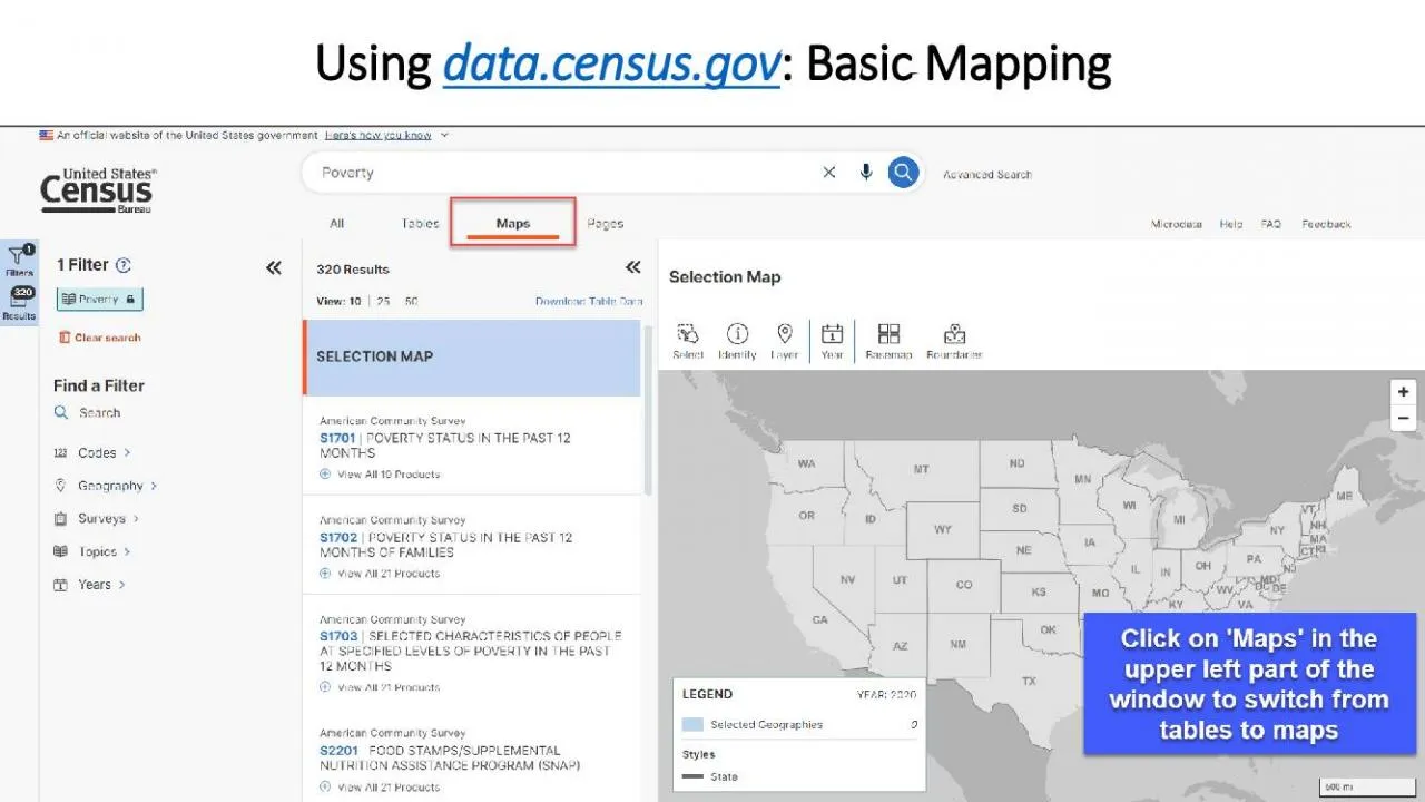
1Using Basic MappingClick on MAPS in the upperleft part of the windowto switch from tables to maps2Usingdatacensusgov Customize MapClick on the CUSTOMIZE MAP button in the upperright corner of the w ID: 898019

state click map button click state button map data left table customize select upper switching hit geographies located view

Share:

Link:

Embed:

Download Presentation from below link

Download Pdf The PPT/PDF document "datacensusgov" is the property of its rightful owner. Permission is granted to download and print the materials on this web site for personal, non-commercial use only, and to display it on your personal computer provided you do not modify the materials and that you retain all copyright notices contained in the materials. By downloading content from our website, you accept the terms of this agreement.


Presentation Transcript

1 1 Using data.census.gov : Basic Mapping
1 Using data.census.gov : Basic Mapping Click on ‘MAPS’ in the upper - left part of the wind

2 ow to switch from tables to maps. 2 Usi
ow to switch from tables to maps. 2 Using data.census.gov : Customize Map Click on the CUSTOMIZE M

3 AP button in the upper - right corner
AP button in the upper - right corner of the window. 3 Left - click on any state and hit ‘Sele

4 ct’ to add a state. 4 Alternatively,
ct’ to add a state. 4 Alternatively, left - click on any state and hit ‘Deselect’ to remove

5 the state. 5 Click on the Rectangle S
the state. 5 Click on the Rectangle Selection Tool in the lower part of the window. Right - cl

6 ick on one of the states and hold the m
ick on one of the states and hold the mouse to draw over all states you would like to add. 6 Th

7 is is a quick way to select multiple g
is is a quick way to select multiple geographies at one time . Please note that any geograph

8 y that touches the rectangle will be a
y that touches the rectangle will be added. 7 To remove a state, remember to left - click on the

9 state and hit ‘Deselect’. 8 In th
state and hit ‘Deselect’. 8 In this example, South Dakota has been deselected. 9 You can q

10 uickly switch between Data Variables, P
uickly switch between Data Variables, Products, and Geographies by using the dropdown menu. 10 S

11 witching between Data Variables 11 Switc
witching between Data Variables 11 Switching between Products 12 Switching between Geographies 13 A

12 nother way to adjust the filters is to
nother way to adjust the filters is to select the Filter button located in the upper left of the

13 screen. This will open the filters menu
screen. This will open the filters menu. 14 To customize a map, click on the CUSTOMIZE MAP button

14 located in the upper - right corner. 1
located in the upper - right corner. 15 To apply further customizations, select the cog icon loc

15 ated beneath the legend. 16 You can cha
ated beneath the legend. 16 You can change the color palette, change the number of data classes,

16 and choose a different classification
and choose a different classification type. 17 To generate a table from the map view, click on

17 the VIEW TABLE button. 18 This gives yo
the VIEW TABLE button. 18 This gives you a preview of the map table. To view the full table, cl

18 ick on the GO TO FULL TABLE button. Yo
ick on the GO TO FULL TABLE button. You can also select the HIDE button to hide the preview scr

Related Contents


Next Show more