/
Model of a Latin American City Model of a Latin American City

Model of a Latin American City - PowerPoint Presentation

phoebe-click
phoebe-click . @phoebe-click
Follow
389 views
Uploaded On 2018-11-02

Model of a Latin American City - PPT Presentation

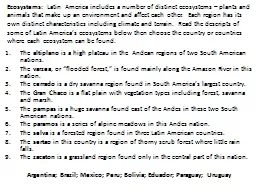
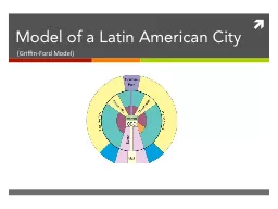
GriffinFord Model History Latin American cities fell under the rule of Spain during the colonial era As such they all followed the same set of regulations and laws known as the Laws of the Indies They allowed Spain to keep reign over its colonies One of the included requirements was for t ID: 709333

class zone city cities zone class cities city cbd residential middle elite spine sector latin american area housing maturity

Share:

Link:

Embed:

Download Presentation from below link

Download Presentation The PPT/PDF document "Model of a Latin American City" is the property of its rightful owner. Permission is granted to download and print the materials on this web site for personal, non-commercial use only, and to display it on your personal computer provided you do not modify the materials and that you retain all copyright notices contained in the materials. By downloading content from our website, you accept the terms of this agreement.


Presentation Transcript

Slide1

Model of a Latin American City

(Griffin-Ford Model)Slide2

History

Latin American cities fell under the rule of Spain during the colonial era. As such, they all followed the same set of regulations and laws known as the Laws of the Indies. They allowed Spain to keep reign* over its colonies. One of the included requirements was for the cities to have a grid pattern established around a central plaza. The wealthy lived near the plaza while the poor lived along the outskirts. This would be the start of the similar patterns found in Latin American cities.

*that rhymed

The Latin American City Model was created by Ernest Griffin and Larry Ford, two geographers, in 1980. They determined that the organization of many cities in this region follow a similar pattern. Eventually, they released a revised model later in 1996 that we now use today.Slide3

The market is located on the other side of the CBD and is less industrialized. It is a traditional area for selling food and goods brought from outside the city (informal economy).

The CBD and Market

The CBD (Central Business District) is where most of the business is focused. It is characterized by compact, high-building densities and high land cost. Many retail store, offices, and cultural activities are concentrated here. It also has the best infrastructure and many means of transportation.Slide4

The Spine contains many amenities, offices, and shops attractive to the wealthy people. It is a narrow strip that juts out from the

CBD. At the end is a mall or edge city for those in the elite sector.

The Elite Residential Sector and Spine

The elite residential sector is the living area of the upper class and the upper-middle class. It has the best housing and forms closely on either side of the spine. The residents frequent the spine and have better services such as water and electricity. Slide5

Gentrification occurs when middle-class residents move back into the inner city to fix the housing. It is located in the Zone of Maturity and helps increase property values.

The Zone of Maturity and Gentrification

The Zone of Maturity is located around the CBD. It has better housing, although not as good as around the spine, and is filled with middle-class residents who moved in after the wealthy moved into the elite residential sector. It has a fully developed infrastructure.Slide6

Middle-Class residential is an outer semi ring on either side of the elite residential sector. It holds middle-class housing and clusters around an agglomeration, such as a mall.

The Zone of in situ Accretion and Middle-Class Residential

The zone of in situ accretion is a transitional area between the zone of maturity (higher class) and the periferico (lower class). It contains housing of modest quality and appears to be in a “constant state of on-going construction”. Homes and infrastructure are unfinished.Slide7

Outside the

disamenity

sector is the zone of peripheral squatter settlements. It is home to the poorest people of the cities. It lacks infrastructure and most people live there illegally.

The

Disamenity

and Peripheral Squatters

The

Disamenity

sticks out from the market like spokes on a wheel and goes through the zone of in situ accretion. It is one of the poorest parts of the city and is not connected to regular city services in some cases. It can be overrun by gangs and drug lords in extreme cases. It is also unique to Latin American cities.Slide8

Now, many Latin American cities have an industrial area or park separate from the CBD.

R

esidents from other sectors work there.

The

Periferico

and the Industrial Park

A

periferico

, or ring highway, connects malls, edge cities, and industrial parks so residents and workers may travel between them easier. It is found encircling the zone of in situ accretion and

disamenity

sectors,

seperating

them from the zone of peripheral squatter settlements. Slide9

Example: Rio

Rio is an example of a city which the Griffin-Ford Model can be applied to. The CBD is located towards the south east. Surrounding the CBD to the east along the spine is the Elite residential area. Towards the west is the zone of maturity, and on the outskirts of town is the peripheral squatter settlements.