/
National Oceanic and Atmospheric Administration National Geodetic Survey National Geodetic National Oceanic and Atmospheric Administration National Geodetic Survey National Geodetic

National Oceanic and Atmospheric Administration National Geodetic Survey National Geodetic - PDF document

phoebe-click
phoebe-click . @phoebe-click
Follow
531 views
Uploaded On 2015-03-10

National Oceanic and Atmospheric Administration National Geodetic Survey National Geodetic - PPT Presentation

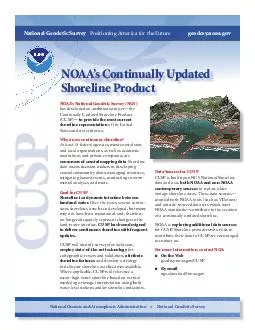
noaagov NOAAs Continually Updated Shoreline Product CUSP Data Sources for CUSP CUSP is built upon NGS National Shoreline data and uses both NOAA and nonNOAA contemporary sources to replace older vintage shoreline areas These data sources coupled with ID: 43553

noaagov NOAAs Continually Updated Shoreline

Share:

Link:

Embed:

Download Presentation from below link

Download Pdf The PPT/PDF document "National Oceanic and Atmospheric Adminis..." is the property of its rightful owner. Permission is granted to download and print the materials on this web site for personal, non-commercial use only, and to display it on your personal computer provided you do not modify the materials and that you retain all copyright notices contained in the materials. By downloading content from our website, you accept the terms of this agreement.


Presentation Transcript

National Oceanic and Atmospheric Administration National Geodetic Survey National Geodetic Survey Positioning America for the Future geodesy.noaa.gov Shoreline Product Data Sources for CUSP CUSP is built upon NGS National Shoreline data and uses both NOAA and non-NOAA contemporary sources to replace older vintage shoreline areas. These data sources— and outside-sourced data sets which meet NOAA standards—contribute to the creation of a continually updated shoreline. NOAA is exploring additional data sources for CUSP. Shoreline providers who wish to contribute their data to CUSP are encouraged to contact us. For more information, contact NGS: On the Web geodesy.noaa.gov/CUSP By email ngs.shoreline@noaa.gov NOAA’s National Geodetic Survey (NGS) Continually Updated Shoreline Product (CUSP)— to provide the most current shoreline representation of the United States and its territories. Why a new continuous shoreline? At least 15 federal agencies, most coastal state and local organizations, as well as academic consumers of coastal mapping data . Shoreline data assists decision makers in developing coastal community plans, managing resources, mitigating hazard events, conducting environ - mental analyses, and more. Goal for CUSP Shoreline is a dynamic interface between Over the years, several contin - uous shorelines have been developed, but many may not have been maintained and, therefore, no longer adequately represent changes to the land-water interface. CUSP has been designed to deliver continuous shoreline with frequent updates. CUSP will identify surveys for inclusion, CUSP for cartographic review and validation, attribute shoreline features , and develop a strategy to delineate shoreline as it becomes available. Where applicable, CUSP will reference a mean-high water shoreline based on vertical modeling or image interpretation using both water level stations and/or shoreline indicators.