Explore
Featured
Recent
Articles
Topics
Login
Upload
Featured
Recent
Articles
Topics
Login
Upload
Search Results for 'Elevation-Line'
Elevation-Line published presentations and documents on DocSlides.
Angles of elevation & depression
by alyssa
Solve problems involving angles of elevation and a...
Angle of elevation and depression
by gagnon
Warm Up. 1.. . Identify the pairs of alternate . ...
8.4 Angles of Elevation and Depression
by cheryl-pisano
-Quiz Friday over Pythagorean Theorem/Special Rig...
MnTOPO – A place to view, print, and download LiDAR Elevation Data
by cheryl-pisano
MnTOPO – A place to view, print, and download L...
Day 3: Angles of Elevation and
by natalia-silvester
Depression. 1/14 and 1/15. EQ: . How do we draw ....
The Role of Moral Elevation in PTSD and Moral Injury
by davies
Adam McGuire, PhD. Postdoctoral . Fellow. VISN 17 ...
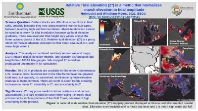
Figure: A national scale relative tidal elevation (Z*) mapping product displayed at diverse well d
by elizabeth
Relative Tidal Elevation (Z*) is a metric that nor...
Online Banking System Trust Elevation
by Younggunner
Online Banking Use Cases. Reference: . http://umld...
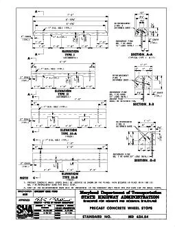
ELEVATION
by elena
TYPE I ELEVATION TYPE II SECTION A-A SECTION B-B E...
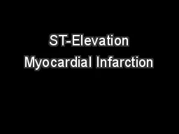
ST-Elevation Myocardial Infarction
by danika-pritchard
(STEMI). Greg Johnsen, MD, FACC, FSCAI. Epidemiol...
Kentucky Aerial Photography and Elevation Data Program - KYAPED
by pasty-toler
National Height Mod Partner Meeting. M. ay 1, 201...
ST-Elevation Myocardial Infarction
by pamella-moone
(STEMI). Greg Johnsen, MD, FACC, FSCAI. Epidemiol...
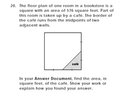
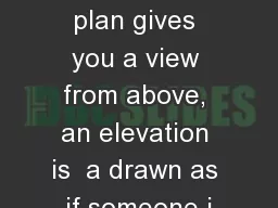
Elevations While a floor plan gives you a view from above, an elevation is a drawn as if someone i
by lois-ondreau
One common use of an elevation is to show the arr...
Elevation and Hydrography
by myesha-ticknor
A match made on earth. USGS, . SouthAtlantic. Wa...
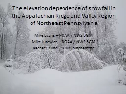
The elevation dependence of snowfall in the Appalachian Rid
by trish-goza
Mike Evans – NOAA / NWS BGM. Mike . Jurewicz. ...
Terrain Analysis Using Digital Elevation Models (
by celsa-spraggs
TauDEM. ). Learning Objectives. To be able to del...
Winter Invertebrate Composition as a Function of Elevation
by min-jolicoeur
How does invertebrate richness, diversity, and ab...
Kentucky Aerial Photography and Elevation Data Program - KY
by myesha-ticknor
National Height Mod Partner Meeting. M. ay 1, 201...
Louisiana Coastal Elevations
by tawny-fly
Slides from Prof. . Roy Dokka. Global sea-level h...
This map shows the elevation in
by trish-goza
meters. Which landforms does this region have?. ...
Do Now Solve the right triangle given the following information:
by cora
. Section 2.4. Solving Right Triangles. Objectiv...
Scientific investigation &
by briana-ranney
mapping. Scientific Method. A . scientific theory...
Topography The Art of Reading &
by yoshiko-marsland
Using Contour Maps. What is a Topographic Map?. E...
Topography
by tatiana-dople
A . map . showing the surface features of an area...
MCAS
by jane-oiler
Bootcamp. Contour Maps!. Random Fact of the Day. ...
IceSat-1
by celsa-spraggs
Ice Team. Sofia Shapiro. Dexter . Becklund. Matth...
What do you know about maps and globes?
by celsa-spraggs
. On the blank paper at your desk complete a bra...
Right Triangle Trig Applications
by helene
Angles of Elevation and Depression. Dr. Shildneck....
UNIT 4: MAPPING THE EARTH
by anastasia
After . Unit . 4 you should be able to:. Accuratel...
Students make a clay model volcano
by elizabeth
25193028192030321and then create a topographic map...
Working Drawings: Exterior Elevations
by liane-varnes
CMCE 1110 Construction Drawings. Professor Anders...
Graphs of Piecewise Linear Functions
by marina-yarberry
Define appropriate quantities from a situation, c...
Graphs of Piecewise Linear Functions
by cheryl-pisano
Define appropriate quantities from a situation, c...
Applications of Trig Functions
by kittie-lecroy
Angle of Elevation. : the angle from the line of ...
MnTOPO – A place to view, print, and download LiDAR Eleva
by karlyn-bohler
Accessing and Viewing Minnesota LiDAR Data On-lin...
Contour Lines
by min-jolicoeur
Contour lines are lines drawn on a map that conne...
8.4 Angles of Elevation and Depression
by alexa-scheidler
Angle of Elevation: the angle formed by a horizo...
Topographic Mapping
by kittie-lecroy
Goals. Define and describe topographic maps.. Def...
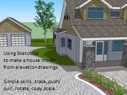
Using
by natalia-silvester
SketchUp. . to make a house model. from elevatio...
Office Hours
by tatyana-admore
Mon: 11:30 AM to 12:30 PM & 1:45 PM to 3:0...
Load More...