Explore
Featured
Recent
Articles
Topics
Login
Upload
Featured
Recent
Articles
Topics
Login
Upload
Search Results for 'Landsat-Data'
Landsat-Data published presentations and documents on DocSlides.
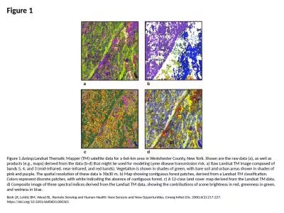
Figure 1 Figure 1. Landsat Thematic Mapper (TM) satellite data for a 6x6-km area in Westch
by cecilia
Beck LR, Lobitz BM, Wood BL. Remote Sensing and Hu...
Use of MODIS data to assess global Landsat surface reflectance products
by aaron
Chengquan. Huang. 1,2. . Min Feng. 1,2. , . Jos...
Landsat Archive, Products, Collection
by marina-yarberry
and . LGAC Status. 21 February 2018. Chris Engebr...
Landsat-8 Calibration Update (Radiometry)
by faustina-dinatale
Landsat Cal/Val Team. Landsat Calibration Meeting...
Landsat BRDF correction:
by susan
recent development and perspective. Hankui Zhang, ...
Landsat: Calculating Surface Reflectance
by giovanna-bartolotta
(from: METRIC: Mapping Evapotranspiration at high...
Landsat 5 Decommission Plan
by kittie-lecroy
Overview to LST. February 12, 2013. Presented By....
Landsat Calibration: Interpolation, Extrapolation, and Reflection
by pamella-moone
LDCM Science Team Meeting. USGS EROS. August 16-1...
Landsat Advisory Group Update
by luanne-stotts
April 2, 2014. Co-Chairs. Kass Green and Roger ...
CEOS Systems Engineering Office (SEO) Data Services for GFO
by trish-goza
Brian Killough. NASA LaRC, CEOS SEO. Presented at...
SEO Data Services Tools for GFOI
by danika-pritchard
Brian Killough. CEOS Systems Engineering Office (...
USGS Headquarters Update
by danika-pritchard
Tim Newman. Program Coordinator. Land Remote Sens...
Examining Surface Reflectance, NDVI and LAI from TM, ETM and OLI for Data Fusion and ET Mapping
by alexa-scheidler
Feng Gao, Martha Anderson, Liang Sun, Yang . Yang...
Resolution Landsat ETM image
by danika-pritchard
Learning Objectives. Be able to name and define t...
Kristi Kline
by olivia-moreira
September 29, 2015. WGISS 40. USGS Plans for Arch...
AmericaView 2016 Update Rick
by danika-pritchard
Lawrence, Emma Bode, Shannon Savage – . Montana...
Landsat Downloads &
by phoebe-click
MODIS . Downloads. Data Sources for GIS in Water ...
Canopy Forest Cover Change in
by stefany-barnette
Fanjingshan. National Nature Reserve:. “What m...
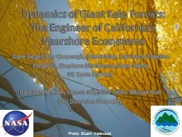
Dynamics of Giant Kelp Forests:
by tatiana-dople
The Engineer of California’s. Nearshore. Ecosy...
Stefan-Boltzmann law governs the radiation of energy by a black body: M = {emissivity} * T
by eve
4. . Emissivity is a constant, so the energy radia...
X II Fórum Ambiental da Alta Paulista
by moistbiker
Estância Turística de Tupã, . 2016. Artigo Comp...
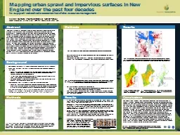
Mapping urban sprawl and impervious surfaces in New England over the past
by phoebe-click
Mapping urban sprawl and impervious surfaces in N...
Which are the best bands???
by phoebe-click
Which bands? . Landsat and . Sentinel. Spectral ...
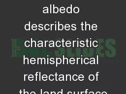
Intrinsic surface albedo describes the characteristic hemispherical reflectance of the land surface
by alexa-scheidler
Near nadir imagers do not provide the multi-angle...
Landsat-based thermal change of Nisyros Island (volcanic)
by aaron
November 2014 lava flow on Kilauea (USGS Volcano ...
1 Remote sensing of snow in visible and near-infrared wavel
by marina-yarberry
Jeff Dozier – UCSB. NASA Snow Remote Sensing Wo...
From Sputnik to Google Earth
by aaron
A Brief History of Satellite Remote Sensing. Sput...
Globiom
by celsa-spraggs
brazil. PRELIMINARY RESULTS. Adriana . Affonso. ...
Landsat-based thermal change of Nisyros Island (volcanic)
by briana-ranney
November 2014 lava flow on Kilauea (USGS Volcano ...
Temporal Reduction of the Ice Shelf in Pine
by olivia-moreira
Island Bay . Antarctica: 1972 - 2003. Abstract . ...
Globiom
by olivia-moreira
brazil. PRELIMINARY RESULTS. Adriana . Affonso. ...
Data management plans and standards for space data: how to
by pasty-toler
BigSkyEarth. , Sorrento, 2016. , Christian Muller...
How to Prepare for Hitachi Vantara HQT-2225 Certification?
by NWExam
Start here--- https://shorturl.at/diI25 ---Get com...
Cohesity COH100 Exam Prep: Important Questions with Answers
by NWExam
Start here---https://shorturl.at/ZPRp9---Get compl...
Working Group: Data Products and Access
by lewis808
Robert Cook, . Oak Ridge National Laboratory. Terr...
Introduction of International Scientific Data Service Platform
by isabella
Scientific Data Center. Computer Network Informati...
CEOS Data Cube Concept and Prototype Project Plans
by karlyn-bohler
Brian Killough. CEOS Systems Engineering Office (...
CEOS Data Cube Open Source Software Status
by pasty-toler
Brian Killough. CEOS Systems Engineering Office (...
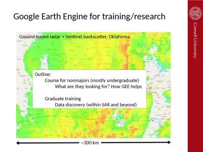
Google Earth Engine for training/research
by maisie
~300 km. Ground-based radar + Sentinel backscatter...
Jed Sundwall, Global Open
by danika-pritchard
Data . Lead. NOAA . . AWS . Big Data Project. W...
Load More...