Explore
Featured
Recent
Articles
Topics
Login
Upload
Featured
Recent
Articles
Topics
Login
Upload
Search Results for 'Landsat'
Landsat published presentations and documents on DocSlides.
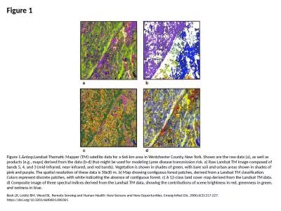
Figure 1 Figure 1. Landsat Thematic Mapper (TM) satellite data for a 6x6-km area in Westch
by cecilia
Beck LR, Lobitz BM, Wood BL. Remote Sensing and Hu...
Landsat BRDF correction:
by susan
recent development and perspective. Hankui Zhang, ...
Landsat Archive, Products, Collection
by marina-yarberry
and . LGAC Status. 21 February 2018. Chris Engebr...
Landsat: Calculating Surface Reflectance
by giovanna-bartolotta
(from: METRIC: Mapping Evapotranspiration at high...
Landsat-8 Calibration Update (Radiometry)
by faustina-dinatale
Landsat Cal/Val Team. Landsat Calibration Meeting...
Landsat 5 Decommission Plan
by kittie-lecroy
Overview to LST. February 12, 2013. Presented By....
Use of MODIS data to assess global Landsat surface reflectance products
by aaron
Chengquan. Huang. 1,2. . Min Feng. 1,2. , . Jos...
Landsat Calibration: Interpolation, Extrapolation, and Reflection
by pamella-moone
LDCM Science Team Meeting. USGS EROS. August 16-1...
Landsat Advisory Group Update
by luanne-stotts
April 2, 2014. Co-Chairs. Kass Green and Roger ...
Stefan-Boltzmann law governs the radiation of energy by a black body: M = {emissivity} * T
by eve
4. . Emissivity is a constant, so the energy radia...
X II Fórum Ambiental da Alta Paulista
by moistbiker
Estância Turística de Tupã, . 2016. Artigo Comp...
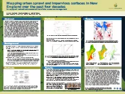
Mapping urban sprawl and impervious surfaces in New England over the past
by phoebe-click
Mapping urban sprawl and impervious surfaces in N...
USGS Headquarters Update
by danika-pritchard
Tim Newman. Program Coordinator. Land Remote Sens...
Which are the best bands???
by phoebe-click
Which bands? . Landsat and . Sentinel. Spectral ...
AmericaView 2016 Update Rick
by danika-pritchard
Lawrence, Emma Bode, Shannon Savage – . Montana...
Intrinsic surface albedo describes the characteristic hemispherical reflectance of the land surface
by alexa-scheidler
Near nadir imagers do not provide the multi-angle...
Examining Surface Reflectance, NDVI and LAI from TM, ETM and OLI for Data Fusion and ET Mapping
by alexa-scheidler
Feng Gao, Martha Anderson, Liang Sun, Yang . Yang...
Landsat-based thermal change of Nisyros Island (volcanic)
by aaron
November 2014 lava flow on Kilauea (USGS Volcano ...
Resolution Landsat ETM image
by danika-pritchard
Learning Objectives. Be able to name and define t...
1 Remote sensing of snow in visible and near-infrared wavel
by marina-yarberry
Jeff Dozier – UCSB. NASA Snow Remote Sensing Wo...
Kristi Kline
by olivia-moreira
September 29, 2015. WGISS 40. USGS Plans for Arch...
From Sputnik to Google Earth
by aaron
A Brief History of Satellite Remote Sensing. Sput...
Globiom
by celsa-spraggs
brazil. PRELIMINARY RESULTS. Adriana . Affonso. ...
Landsat-based thermal change of Nisyros Island (volcanic)
by briana-ranney
November 2014 lava flow on Kilauea (USGS Volcano ...
Landsat Downloads &
by phoebe-click
MODIS . Downloads. Data Sources for GIS in Water ...
Canopy Forest Cover Change in
by stefany-barnette
Fanjingshan. National Nature Reserve:. “What m...
CEOS Systems Engineering Office (SEO) Data Services for GFO
by trish-goza
Brian Killough. NASA LaRC, CEOS SEO. Presented at...
Temporal Reduction of the Ice Shelf in Pine
by olivia-moreira
Island Bay . Antarctica: 1972 - 2003. Abstract . ...
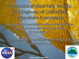
Dynamics of Giant Kelp Forests:
by tatiana-dople
The Engineer of California’s. Nearshore. Ecosy...
Globiom
by olivia-moreira
brazil. PRELIMINARY RESULTS. Adriana . Affonso. ...
SEO Data Services Tools for GFOI
by danika-pritchard
Brian Killough. CEOS Systems Engineering Office (...
Working Group: Data Products and Access
by lewis808
Robert Cook, . Oak Ridge National Laboratory. Terr...
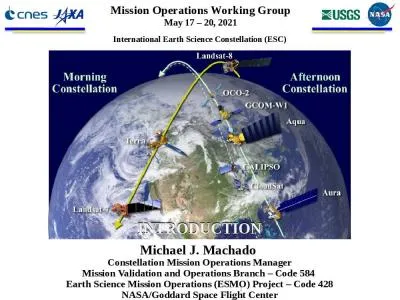
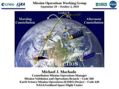
International Earth Science Constellation (ESC)
by faith
1. Michael J. Machado . Constellation Mission Oper...
1 Michael J. Machado Constellation Mission Operations Manager
by hailey
Mission . Validation and Operations Branch – Cod...
Introduction of International Scientific Data Service Platform
by isabella
Scientific Data Center. Computer Network Informati...
HTCondor Workflow Development for Statistical Modeling of
by joanne
Satellite Image Time Series . with Ancillary Data....
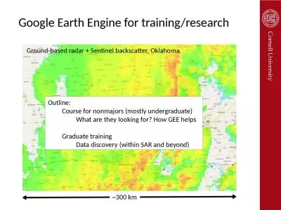
Google Earth Engine for training/research
by maisie
~300 km. Ground-based radar + Sentinel backscatter...
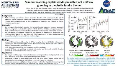
Background: Arctic warming can influence tundra ecosystem function with consequences for climate fe
by thomas
Methods:. We generated phenologically-modeled time...
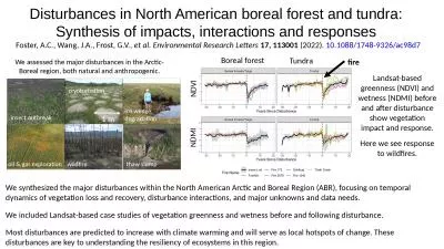
Disturbances in North American boreal forest and tundra:
by williams
Synthesis of impacts, interactions and responses ....
Terra 2.0 – The Vision
by daniella
Continuation and continuity of the Terra (AM polar...
Load More...