Explore
Featured
Recent
Articles
Topics
Login
Upload
Featured
Recent
Articles
Topics
Login
Upload
Search Results for 'Mapping-Spatial-Data-From-Multiple-Sources'
Mapping-Spatial-Data-From-Multiple-Sources published presentations and documents on DocSlides.
Mapping Spatial Data from Multiple Sources
by stefany-barnette
Olivia Gill, Bruce Smith and John Dawson. Explosi...
Concept Mapping Mind Mapping and Argument Mapping The University of
by mackenzie
these tools may offer educators as yet unrealised ...
MULTIPLE INTELLIGENCES “The theory of multiple intelligences was developed in 1983 by
by natalia-silvester
Dr. Howard Gardner, professor of education at Har...
Mapping Urban Economies Beyond National Histories. Spatial-Economic Organizations of Ottoman Neighb
by arya
M. . Erdem. . Kabaday. ı. , . Istanbul . Bilgi. ...
Design-Time/Run-Time Mapping of Security-Critical
by pasty-toler
Applications in Heterogeneous . MPSoCs. Andreas ....
Mapping Urban Economies Beyond National Histories. Spatial-
by debby-jeon
M. . Erdem. . Kabaday. ı. , . Istanbul . Bilgi....
Market mapping Market mapping
by giovanna-bartolotta
This section covers the following: . What market ...
Multibeam Mapping The Evolution of Mapping the Ocean
by myesha-ticknor
Lead line mapping. Lead line mapping was the earl...
The Multiple Sclerosis Solution™ Free PDF eBook by Jodi Knapp
by Thicaterfe
Jodi Knapp: The Multiple Sclerosis Solution PDF, T...
Geog 301: Lecture 4 The value of spatial data
by elina
Again, portions swiped from Dr. Sterling Quinn. Wh...
Preparing Spatial Data to Archive
by jocelyn
Yaxing . Wei. . &. Suresh K.S. . Vannan. Envi...
Organization Spatial Data Mining Fall 2011
by claire
Introduction. Region Discovery—Finding Interesti...
Locational Analytics, Spatial Decision-Making and Big Data:
by tatyana-admore
Overview . of Spatial Big Data and . Analytics. (...
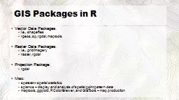
Spatial data in R
by sherrill-nordquist
M Sumner. Outline. Packages. Spatial. Import and ...
Multiplexor A multiplexor is a device that takes a number of data inputs and selects one of them to
by jane-oiler
The interface of a multiplexor provides means to ...
Collaborative Data Sharing with Mappings and Provenance
by olivia-moreira
Todd J. Green. University of Pennsylvania. Spring...
Challenges and Solutions for Mapping Pathology Data to SEND
by olivia-moreira
. Mike Wasko, Rich Buchanan, Fred Mura, and Laur...
LoS MIMO
by windbey
ECE Department. University of California, Santa Ba...
LoS MIMO Upamanyu Madhow
by liane-varnes
ECE Department. University of California, Santa B...
A CyberGIS Environment for Near-Real-Time Spatial
by shangmaxi
Analysis. . of . Social Media Data . Shaowen Wang...
Moving Toward Spatial Access: Lessons Learned
by conchita-marotz
Daniel Carter. UNC Highway Safety Research Center...
Introduction to Spatial Database System
by aaron
Presented by . Xiaozhi. Yu. Outline. What is spa...
Spatial Database Systems
by ellena-manuel
Tyler Reainthong. CSE 7330. Fall 2009. Topics. De...
Intro to Spatial Analysis with
by luanne-stotts
What can we do with GIS?. SPATIAL STATISTICS. Wha...
Regional marine spatial planning
by briana-ranney
- the Shetland experience. Rachel . Shucksmith. M...
Role of Spatial Database
by myesha-ticknor
in. Biodiversity Conservation Planning. Sham . Da...
dMazeRunner : Executing Perfectly Nested Loops on Dataflow Accelerators
by clara
Shail Dave. 1. , . Youngbin. Kim. 2. , . Sasikant...
What is a GIS? Geospatial technologies are technolo-gies for collecting and dealing with geographic
by tawny-fly
three main types: . . Global Positioning Systems...
FROMENTAL – KIKU 01These panels feature the finest hand-painted d
by lam
For further information, please view our showrooms...
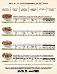
CaloriesCalories fromFatFat-TotalSaturatedFatTransFattyAcidsterolTotal
by alexa-scheidler
CaloriesCalories fromFatFat-TotalSaturatedFatTrans...
RAMP: Resource-Aware Mapping for CGRAs
by dandy
Shail Dave. ,. Mahesh Balasubramanian, Aviral Shr...
Update Exchange with Mappings and Provenance
by alida-meadow
Todd J. Green. Grigoris Karvounarakis Zachar...
Risk Mapping, Assessment, and Planning
by kittie-lecroy
RiskMAP in Oklahoma. Gavin Brady, CFM, State NFIP...
Mapping Requirements &
by alexa-scheidler
Processing T-4 . Forms. Pipeline Safety Division....
Using Semantic Mapping to Manage Heterogeneity in XLIFF Int
by alida-meadow
by. Dave Lewis, . Rob Brennan, . Alan Meehan, Dec...
Crime Mapping Level 1
by alida-meadow
BCJI . Webinar. February 23, 2015. What is a GIS?...
H. François P. Spandre, S. Morin et E. George
by brown
PySciDataGre. , Grenoble, 8 . février. 2019. Fro...
What Spatial Thinking Skills are Important in Hydrogeology?
by freya
Peggy McNeal. 1. , Heather Petcovic. 2. , Joel Moo...
Estimating Mortality from Pneumoconiosis Using Multilevel Spatial Binary Regression
by playhomey
Rajib Paul, PhD. University of North Carolina at C...
Spatial Query Languages
by yoshiko-marsland
Standard Database Query Languages. Outline. What ...
Load More...