/
computer-based cartographic communication theory computer-based cartographic communication theory

computer-based cartographic communication theory - PowerPoint Presentation

susan2
susan2 . @susan2
Follow
27 views
Uploaded On 2024-02-02

computer-based cartographic communication theory - PPT Presentation

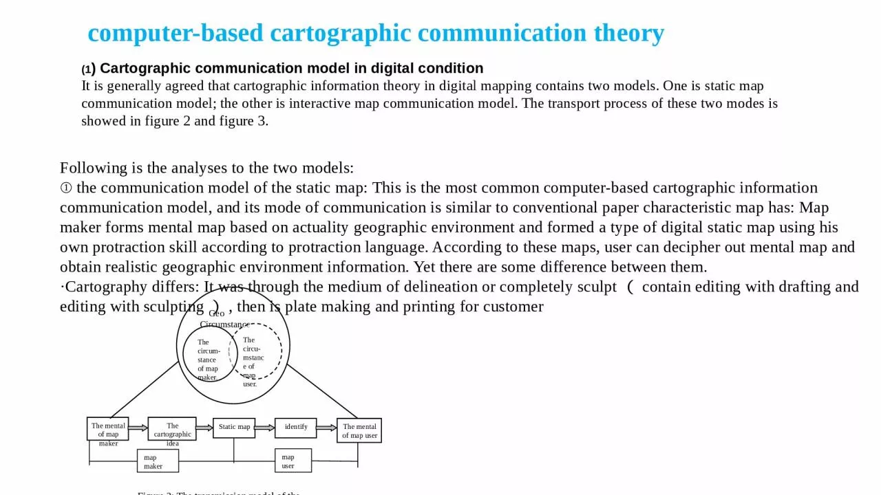
1 Cartographic communication model in digital condition It is generally agreed that cartographic information theory in digital mapping contains two models One is static map communication model the other is interactive map communication model The transport process of these two modes is showed ID: 1043623

communication map cartographic information map communication information cartographic user theory model computer maker mental conventional making based process form

Share:

Link:

Embed:

Download Presentation from below link

Download Presentation The PPT/PDF document "computer-based cartographic communicatio..." is the property of its rightful owner. Permission is granted to download and print the materials on this web site for personal, non-commercial use only, and to display it on your personal computer provided you do not modify the materials and that you retain all copyright notices contained in the materials. By downloading content from our website, you accept the terms of this agreement.


Presentation Transcript

1. computer-based cartographic communication theory(1) Cartographic communication model in digital conditionIt is generally agreed that cartographic information theory in digital mapping contains two models. One is static map communication model; the other is interactive map communication model. The transport process of these two modes is showed in figure 2 and figure 3.The mental of map makerThe cartographic ideaStatic mapidentifyThe mental of map usermap makermap userGeo CircumstanceThe circu-mstance of map user.The circum-stance of map maker.Figure 2: The transmission model of the static mapFollowing is the analyses to the two models: ① the communication model of the static map: This is the most common computer-based cartographic information communication model, and its mode of communication is similar to conventional paper characteristic map has: Map maker forms mental map based on actuality geographic environment and formed a type of digital static map using his own protraction skill according to protraction language. According to these maps, user can decipher out mental map and obtain realistic geographic environment information. Yet there are some difference between them.·Cartography differs: It was through the medium of delineation or completely sculpt(contain editing with drafting and editing with sculpting), then is plate making and printing for customer

2. use' paper characteristic map, whereas under conditions of computer the cartography general is digitalization(whole digital photogrammetry, analyses mapping, track-while-scan, manual tracking etc)to get map data.·Map form differs: The user can only get paper characteristic map (including those printed on others material) through traditional method, and with the help of computer, user can get different types of map. The most common way is to get screen map showed on a computer monitor accompanied with additional information like sound and image. If needed, user can also get paper characteristic map by printing or plate making and printing. · Recognition mode differs: Digital map could supply polymorphous content at the same time and can given user outspend latitude’s recognition space. It also can help user form much more actual mental map from realism geographic environment.The mental of map makerThe cartographic ideaInteractive mapIdentifyThe mental of map userMap makerMap userFeedback chainGeo Circumstance

3. interactive map communication model: It is a type of new fashioned cartographic communication model. The mental map that map maker formed form the real world is used to form a type of interactive map through abstract approach accompanied with some kind of user interface by utilizing the map maker's protraction knowledge. User formed the mental map of the real world through the recognition of such interactive map. What is specific here is that there is a feedback link in the process of recognition. User can correct his mental map according to the interactive map and can make more use of interactive map using his own knowledge.(2) A new cartographic communication model in digital conditionWith the development of science and technology and the wide appliance of computer technology in cartographic field, many new fashioned cartographic products, for instance, different kinds of multimedia map, virtual reality (VR) and tridimensional map, has been developed. The form and function of these products have gone far beyond of tradition map and a type of new cartographic communication model is in great need of to explain the computer-based cartographic communication theory.

4. Geo Circumstance

5. As showed in figure four, cartographer simply forms his own mental map from the real world, and through abstraction and contraction user interface to supply user with universal data and tools to make different kinds of map. The user can produce various type of maps he needed by processing the data. In this part, the function of simple cartographer has been much reduced. Some work of the cartographer's is now completed by map user, in other words, the map user is not simply an user ,but also is communed with map maker and can not be distinguished clearly. (This model only describes different kinds of new cartographic communication theory, not all cartographic communication theory).The speciality of such new mode of communication can be analyzed in four aspects as follows:① Reduction of the cartographic information loss during the transporting processFrom the points of information transfer, cartographic information has its own speciality: Its capacity is made up of graphics and information. It is an open carrier, which means that the information contained in a map can be utilized by everyone who has the ability to and wants to use it. The process of such individual compilation and great master usage is called one-to-all process. Accordingly this kind of system is called one-to-all system. There are two kinds of cartographic information loss during the protraction information transfer process. · Information content conceptual loss

6. The first type of loss is determined by the speciality of cartographic information transmission. Such loss has its purpose. To represent the interdependent spatial information with map, we must project three-dimensional spatial information to two-dimensional surface through certain mathematics theorem. On the other hand, it is impossible to represent all geographic environment information at limited map space and the filtration must be used to select the element need to be expressed. Conventional communication theory is helpless in this two aspects and computer-based communication theory can reduce or even avoid these problems to some extent. For instance, virtual reality (VR) can be used to solve the problem caused by two-dimensional display, that is to say, we can fix up the vice existed in two-dimension map utilizing the three-dimensional display technology. The loss caused by selected filtration using single scale map can be reduced by using multilevel scale map, which can not be accomplished in conventional communication theory.The material handling loss is caused by the limited capacity of a map. The feasibility of map denotation is restricted by map capacity and the map capacity is limited by the structure, size and chromatic of graphic symbol, in other words, it is limited by the map language used and its rule. Some other factors are the size of the map, the means that map to be used, the quality of the paper, the print technology and the amount of the color adopted etc. These can not be avoided in conventional cartographic communication theory. But computer-based communication theory could alleviate the influence to a great extent. Supported by the map database, more attribute information can be obtained compare to conventional map; on the other hand, electronic map can avoid the restriction in printing conditional of conventional map and express geo information and attribute information far better.② The improvement of communication efficiencyCartographic information communication efficiency points to average information content before information transfer subtract average information content loss during the transport process. Map making begins when a map maker wants to transfer some of his cognition to others. This transfer operation first requires the map maker form the concept of a map.

7. The map maker must select, sort and simplify the spatial information which are the three main processes of forming concept of a map. These there processes are all have their own characteristic. In conventional cartographic information transport process, the map user is separated with map maker. Map maker can never know completely the purpose of map user, wherefore, the map formed after the three processes can not meet fully of the request of map user. The communication efficiency then is reduced. In the new communication model, map maker and user are communed together and are capable of express the content they needed completely in map. The communication efficiency is improved much in this way.③ The improvement of map-making efficiencyConventional cartography requires four processes. They are map design, map compilation, publish prepare and map print. Such technology can not meet the ever-growing requirement of modern economy, national defense, science and technology in the aspect of map-making quality and production cycle. With the development of computer technology automatic control engineering, map making technology has great change. The base process of modern computerized mapping can be divided into four stages: Redact preparing, digitalization, programming, computer processing and editing and graphic outputting. The efficiency of map-making is greatly improved in this way. In addition, in map updating, the predominance of this method is more evident. Unlike conventional approach that all process should be repeated, the new method only needs to add new content to original data to update the map. 

8. Map design and compilation are the main task of map maker in conventional cartographic communication theory. Map makers form their own mental map from the real world and form the map using symbol system and cartographic convention according certain purpose. Map users can only use available maps. Yet in computer-based communication model, the only task of map makers is to supply map users with universal data and tools which are used to produce different type of maps through abstracting and constructing user interface. Map users share part work of map makers' to produce maps more suitable for their requirement. Therefore, compared to traditional theory, such new model has great change in map design and compilation.Map information's communication theory has profound impact to the development of cartography, it has important practical meaning. But up to now, this theory is not maturity completely. Wherefore it need to incorporation ultramodern map making technique to perfect and refill continually. So that it can supply theory direction to map making and application, promote the research of cartography theory. Based on synthesizing and analyzing different kinds of conventional communication model and combine with ultramodern map making technique and cartography theory, this article bring up a cartographic communication model that based on computer, it is a consummating to cartographic communication theory in new condition.