
Narrowing the gap for city building height
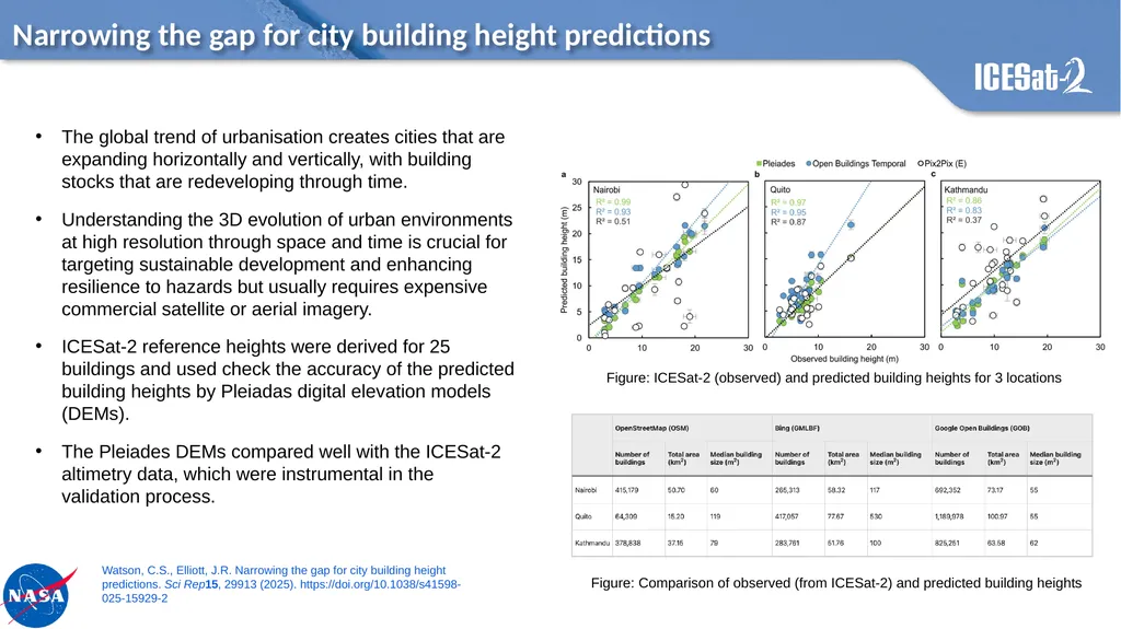
Description: Narrowing the gap for city building height predictions Figure: ICESat-2 (observed) and predicted building heights for 3 locations Figure: Comparison of observed (from ICESat-2) and predicted building heights The global trend of urbanisation
Related Topics
Download Presentation
"Narrowing the gap for city building height" is the property of its rightful owner. Permission is granted to download and print the materials on this website for personal, non-commercial use only, and to display it on your personal computer provided you do not modify the materials and that you retain all copyright notices contained in the materials. By downloading content from our website, you accept the terms of this agreement.
Presentation Transcript
slide1. Narrowing the gap for city building height predictions Figure: ICESat-2 (observed) and predicted building heights for 3 locations Figure: Comparison of observed (from ICESat-2) and predicted building heights The global trend of urbanisation creates cities that are expanding horizontally and vertically, with building stocks that are redeveloping through time.
Understanding the 3D evolution of urban environments at high resolution through space and time is crucial for targeting sustainable development and enhancing resilience to hazards but usually requires expensive commercial satellite or aerial imagery.
ICESat-2 reference heights were derived for 25 buildings and used check the accuracy of the predicted building heights by Pleiadas digital elevation models (DEMs).
The Pleiades DEMs compared well with the ICESat-2 altimetry data, which were instrumental in the validation process. Watson, C.S., Elliott, J.R. Narrowing the gap for city building height predictions. Sci Rep15, 29913 (2025). https://doi.org/10.1038/s41598-025-15929-2<br>
Understanding the 3D evolution of urban environments at high resolution through space and time is crucial for targeting sustainable development and enhancing resilience to hazards but usually requires expensive commercial satellite or aerial imagery.
ICESat-2 reference heights were derived for 25 buildings and used check the accuracy of the predicted building heights by Pleiadas digital elevation models (DEMs).
The Pleiades DEMs compared well with the ICESat-2 altimetry data, which were instrumental in the validation process. Watson, C.S., Elliott, J.R. Narrowing the gap for city building height predictions. Sci Rep15, 29913 (2025). https://doi.org/10.1038/s41598-025-15929-2<br>