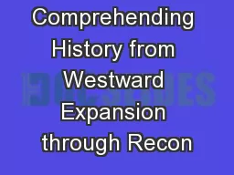
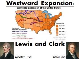
Meriwether Lewis William Clark Westward Expansion was from 1801 to 1861 Americans began to explore more territories to expand the US Main Territories explore Louisiana Purchase 1803 ID: 935228
Download Presentation The PPT/PDF document "Westward Expansion: Lewis and Clark" is the property of its rightful owner. Permission is granted to download and print the materials on this web site for personal, non-commercial use only, and to display it on your personal computer provided you do not modify the materials and that you retain all copyright notices contained in the materials. By downloading content from our website, you accept the terms of this agreement.
Slide1
Westward Expansion:
Lewis and Clark
Meriwether Lewis William Clark
Slide2Westward Expansion
was from 1801 to 1861. Americans began to explore more territories to expand the U.S. Main Territories explore:
Louisiana Purchase (1803)Florida (1819)
Texas (1845)Oregon (1846)California (1848)
Slide32. Louisiana Purchase was a deal made by President Jefferson in 1803. He bought land from France that doubled the size of the U.S.
This is the land Lewis and Clark were sent to explore.
Slide43.
Lewis and Clark Expedition started on the Mississippi River to the Missouri River. Then they went to the Rocky Mountains and did not stop until they reached the Pacific Ocean.
Slide54. Meriwether Lewis was Thomas Jefferson’s personal secretary who the commander of the expedition.
5. William Clark was a frontiersman who could draw maps, navigate rivers, and understand geography.
Slide66. Sacagawea was a Native American who guided and helped Lewis and Clark to the Pacific Ocean.
Sacagawea was Shoshone Indian who was pregnant when she joined the Corps of Discovery group in North Dakota on the Missouri River. She communicated with other natives for horses to travel over the Rocky Mountains; A Shoshone Chief, her brother.
Slide7REVIEW PHYSICAL FEATURES OF THE UNITED STATES
Slide8Atlantic Coastal Plain
It has many excellent harbors. Many people live in the Atlantic Coastal Plain Region.This lowland area borders the Atlantic Ocean in the eastern part of the United States.
Slide9Great Plains
This area consists of grasslands with no trees, and you can see for miles and miles.
The flat area in the middle of the United States, west of the Interior Plains and east of the Rocky Mountains.
Slide10Continental Divide
On the eastern side of the divide, rivers flow toward the Atlantic Ocean or the Gulf of Mexico. On the western side, rivers flow toward the Pacific Ocean.The high peaks of the Rocky Mountains form this imaginary line known as the “backbone of North America”.
Slide11Westward Expansion:
War of 1812
America England
Slide121.
War of 1812 was a war between America and England. France helped America as the Native Americans helped England. The war ended in 1814 with a “draw”, both sides claimed victory.
Slide132. White House is the U.S. President’s house in Washington, D.C. It was burnt down during the War of 1812 and later rebuilt.
3.
Capitol Building
is the place where the U.S. Congress meet. It was burnt down during the War of 1812 and later rebuilt.
Slide144. Texas is a state the U.S. fought Mexico for during the Westward Expansion. Texas joined the U.S. i
n 1845.5. Alamo was a Spanish mission in Texas where a famous battle took place between America and Mexico during Westward Expansion.
Slide156. Oregon Trail was a well-marked trail to show pioneers the way out west in covered wagons.
Slide167. California is a state the U.S. fought Mexico for during the Westward Expansion. California joined the U.S. i
n 1848.8. California Gold Rush was in 1848 when gold was discovered. Many people began traveling out west to find gold.
Slide179. Florida was a piece of land turned over by Spain to the United States in 1819.
Slide18Westward Expansion:
Barriers and Gateways
Slide191.
Physical Barriers
are landforms that hindered expansion such as the Rocky Mountains and deserts.
The Great Basin
Slide202. Physical Gateways are landforms that benefited expansion such as the Great Lakes, Missouri River, and the Great Plains.
The Great Plains
Great Lakes
Missouri River
Slide213.
Territorial Expansion
is the growth of a territory across the country.
4.
The Indian Removal Act of 1830
was a treaty with Native Americans to exchange land across the Mississippi River; however,
the Indians
were forced off
their land.
MISSISSIPPI RIVER
Slide225.
The Americanization Policy
was designed to introduce Indians to the European-American ways of life and combine them with their own tribal traditions.
Slide236. Invention is an object that has never been made before.
7. Steamboat was an invention by Robert Fulton in 1807 to transport people and goods on rivers and canals.
Slide248.
Steam Locomotive was an invention by George Stephenson in 1814 to transport raw materials and goods quickly over land.
9. Telegraph was an invention by Samuel Morse in 1837 to provide long distance communication.