/
NATIONAL HURRICANE CENTER TROPICAL CYCLONE REPORTTROPICAL STORM ANA NATIONAL HURRICANE CENTER TROPICAL CYCLONE REPORTTROPICAL STORM ANA

NATIONAL HURRICANE CENTER TROPICAL CYCLONE REPORTTROPICAL STORM ANA - PDF document

badra
badra . @badra
Follow
346 views
Uploaded On 2021-10-02

NATIONAL HURRICANE CENTER TROPICAL CYCLONE REPORTTROPICAL STORM ANA - PPT Presentation

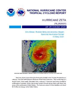
2223 May 2021 3 August 2021 NASATERRA MODERATE RESOLUTION IMAGING SPECTRORADIOMETER MODIS IMAGERY OF SUBTROPICAL STORM ANA AT 1507 UTC 22 MAY 2021 IMAGE COURTESY OF NASA EOSDIS WORLDVIEW Ana origina ID: 893416

storm ana utc tropical ana storm tropical utc wind cyclone subtropical 0600 extratropical intensity pressure winds track 0000 table

Share:

Link:

Embed:

Download Presentation from below link

Download Pdf The PPT/PDF document "NATIONAL HURRICANE CENTER TROPICAL CYCLO..." is the property of its rightful owner. Permission is granted to download and print the materials on this web site for personal, non-commercial use only, and to display it on your personal computer provided you do not modify the materials and that you retain all copyright notices contained in the materials. By downloading content from our website, you accept the terms of this agreement.


Presentation Transcript

1 NATIONAL HURRICANE CENTER TROPICAL CYCLO
NATIONAL HURRICANE CENTER TROPICAL CYCLONE REPORTTROPICAL STORM ANA 22–23 May 2021 3 August 2021 NASA/TERRA MODERATE RESOLUTION IMAGING SPECTRORADIOMETER (MODIS) IMAGERY OF SUBTROPICAL STORM ANA AT 1507 UTC 22 MAY 2021. IMAGE COURTESY OF NASA EOSDIS WORLDVIEW. Ana originated from a large extratropical cyclone that developed east of Bermuda. It transitioned to a subtropical storm, and then became a tropical storm while moving northeastward out to sea. Ana briefly produced gale-force winds near and over portions of end of its extratropical cyclone phase. Tropical Storm Ana 2 Tropical Storm Ana22–23 MAY 2021 SYNOPTIC HISTORY Ana developed from a large, extratropical cyclone that formed over the central Atlantic Ocean. On 19 May, a mid- to upper-level shortwave trough dug southeastward over the western North Atlantic and moved toward a nearly stationary baroclinic zone that was draped across the central Atlantic. The upper-level diffluence associated with the shortwave trough induced surface low pressure development along the stalled front roughly 500 n mi east-southeast of Bermuda, and the low became evident in scatterometer data short

2 ly after 0000 UTC 20 May. The extratrop
ly after 0000 UTC 20 May. The extratropical cyclone (Fig. 1a) quickly developed gale-force winds in its northern semicircle that morning, and storm-force winds early on 21 May as a surface ridge strengthened to the northeast of the now occluded low. The cyclone’s asymmetric wind field expanded during this period, with gale-force winds reaching as far as 330 n mi from the center in the northeast quadrant. The cyclone initially moved northeastward on 20 May, but it became caught in the flow of a cutoff upper-level low soon thereafter, which caused the system to accelerate west-northwestward and then westward on 21 May. The cyclone slowed down as it moved underneath the upper-level low early on 22 May. This orientation reduced the vertical wind shear over the surface low, and also provided enhanced instability aloft that allowed some moderate convection to develop near the center, despite sea-surface temperatures (SSTs) of only 21° to 22°C. The convection began showing some signs of organization early on 22 May as the surface low finished shedding its frontal structure. Since the system was collocated with the upper-level low and had a large radiu

3 s of maximum wind (60 n mi), it is estim
s of maximum wind (60 n mi), it is estimated that Subtropical Storm Ana formed by 0600 UTC 22 May, when it was located about 175 n mi northeast of Bermuda. The “best track” chart of Ana’s path is given in Fig. 2, with the wind and pressure histories shown in Figs. 3 and 4, respectively. The best track positions and intensities are listed in Table 1Ana completed a small, counter-clockwise loop on 22 May under the influence of only weak steering currents. Several scatterometer passes that morning indicated the tropical-storm-force wind radii had contracted from the previous day and the system had weakened, with maximum sustained winds of around 35 kt. The moderate convection associated with Ana was organized into a couple of bands displaced well away from the fully exposed low-level center (cover photo; Fig. 1b). Late on 22 May, Ana began producing a small, more persistent area of moderate convection near and over its center. Shortly thereafter, a 0054 UTC 23 May scatterometer pass revealed Ana had developed a more symmetric surface wind field, and the A digital record of the complete best track, including wind radii, can be found on line at . Da

4 ta for the current year’s storms are loc
ta for the current year’s storms are located in the directory, while previous years’ data are located in the archive directory. Tropical Storm Ana 3 radius of maximum wind had decreased to 15 n mi. Thus, it is estimated that Ana transitioned to a tropical storm by 0000 UTC 23 May, when it was located about 205 n mi northeast of Bermuda. The compact tropical cyclone began accelerating northeastward on 23 May when it became embedded within deep-layer southwesterly flow between a ridge to its southeast and an amplifying trough over Atlantic Canada. A flare-up of moderate convection, combined with the increased forward speed of Ana, helped the cyclone reach an estimated peak intensity of 40 kt from 0000 UTC to 0600 UTC 23 May. Soon thereafter, Ana encountered an environment of cooler SSTs (°C) and increasing wind shear, which led to a decrease in convection and slight weakening of the cyclone later that morning. By 1800 UTC that day, Ana lost all deep convection and became a 35-kt post-tropical cyclone. The system continued accelerating northeastward, and scatterometer data around 0100 UTC 24 May indicated that the cyclone had opened up i

5 nto a trough while located about 525 n m
nto a trough while located about 525 n mi northeast of Bermuda. Later that day, the trough merged with a strong cold front that was racing eastward across the North Atlantic Ocean. METEOROLOGICAL STATISTICS Observations in Ana (Figs. 3 and 4) include subjective satellite-based Hebert-Poteat subtropical technique intensity estimates from the Tropical Analysis and Forecast Branch (TAFB), Dvorak technique intensity estimates from TAFB and the Satellite Analysis Branch (SAB), objective Advanced Dvorak Technique (ADT) estimates and Satellite Consensus (SATCON) estimates from the Cooperative Institute for Meteorological Satellite Studies/University of Wisconsin-Madison. Data and imagery from NOAA polar-orbiting satellites including the Advanced Microwave Sounding Unit (AMSU), the NASA Global Precipitation Mission (GPM), the European Space Agency’s Advanced Scatterometer (ASCAT), and Defense Meteorological Satellite Program (DMSP) satellites, among others, were also useful in constructing the best track Selected ship reports of winds of tropical storm force associated with Ana are given in Table 2, and selected surface observations from land and marine sta

6 tions are given in Table 3. Winds and Pr
tions are given in Table 3. Winds and Pressure The extratropical cyclone from which Ana developed is estimated to have reached a peak intensity of 50 kt from 0000 UTC to 0600 UTC 21 May. A partial ASCAT-A pass at 2240 UTC 20 May revealed an area of 45-kt winds displaced well northeast of the circulation center. Model wind analyses (not shown) suggest higher wind speeds occurred shortly thereafter to the north of the bent-back occlusion associated with the extratropical cyclone. The strongest winds reported on Bermuda occurred while the system was an extratropical cyclone. At Pearl Island, a sustained wind of 38 kt with a gust to 43 kt was measured at 2332 UTC 21 May, over six hours before the system transitioned to a subtropical storm. Several other Tropical Storm Ana 4 locations on the island measured tropical-storm-force gusts early on 22 May, shortly before Ana became a subtropical cyclone. Ana’s estimated peak intensity as a tropical storm is 40 kt from 0000 UTC to 0600 UTC 23 May. An ASCAT-B pass at 0051 UTC 23 May showed winds up to 36 kt in the southeastern quadrant of Ana. Shortly thereafter, a small area of convection became

7 more concentrated near the center as the
more concentrated near the center as the system was accelerating northeastward. Since the resolution of scatterometer data does not adequately sample the peak winds in small tropical cyclones like Ana, it is likely that the wind speed peaked around 40 kt early on 23 May. This is supported by a 0600 UTC 23 May Hebert-Poteat classification of 35–40 kt from TAFB. The estimated minimum central pressure of 1004 mb at 0600 UTC 23 May is based on the Knaff-Zehr-Courtney pressure wind relationship. CASUALTY AND DAMAGE STATISTICS There were no reports of casualties or damage associated with Ana. FORECAST AND WARNING CRITIQUE Despite its extratropical origins, Ana’s genesis was forecast well for an out-of-season tropical cyclone (Table 4). A noteworthy NHC product change in 2021 was the routine issuance of the Atlantic Tropical Weather Outlook (TWO) beginning on 15 May, in order to provide more consistent information on the potential for systems that could develop in late May, such as Ana. The disturbance from which Ana developed was introduced in the low (40%) category of the 5-day TWO 72 h before it became a subtropical storm. The 5-day probabilities

8 were raised to the medium (40–60%) and &
were raised to the medium (40–60%) and .70;high (60%) categories 60 h and 48 h before formation, respectively. For the 2-day probabilities, a low chance of genesis was introduced 60 h, a medium chance 48 h, and a high chance 42 h before formation, respectively. A verification of NHC official track and intensity forecasts for Ana is given in Tables 5 and 6, respectively. Official forecast track errors were slightly greater than the mean official errors for the previous 5-yr period, albeit for a small sample size of only four verifying 12-h forecasts and two 24-h forecasts. Official forecast intensity errors were lower than the mean official errors for the previous 5-yr period. Due to Ana’s brief existence as a subtropical and tropical storm, no The Bermuda Weather Service issued a Tropical Storm Watch for the island at 1500 UTC 20 May. The watch was never upgraded to a warning, and it was discontinued at 1500 UTC 22 May. Tropical Storm Ana 5 Table 1. Best track for Tropical Storm Ana, 22–23 May 2021. Date/Time (UTC) (°N) Speed (kt) Stage 20 / 0000 30.3 55.5 1015 30 extratropical 20 / 0600 31.5 54.5 1013 35 " 20 / 1200 33.0 5

9 3.0 1012 40 " 20 / 1800 34.2 53.8 1010
3.0 1012 40 " 20 / 1800 34.2 53.8 1010 45 " 21 / 0000 34.8 55.0 1008 50 " 21 / 0600 35.5 57.0 1006 50 " 21 / 1200 35.7 59.3 1005 45 " 21 / 1800 35.0 61.1 1005 45 " 22 / 0000 34.5 61.8 1006 40 " 22 / 0600 34.2 62.1 1006 35 subtropical storm 22 / 1200 34.3 62.7 1006 35 " 22 / 1800 34.2 62.4 1006 35 " 23 / 0000 34.7 61.8 1005 40 tropical storm 23 / 0600 35.4 61.1 1004 40 " 23 / 1200 36.1 60.3 1005 35 " 23 / 1800 36.8 58.7 1006 35 low 24 / 0000 37.6 56.7 1007 35 " 24 / 0600 dissipated 23 / 0600 35.4 maximum wind and minimum pressure Tropical Storm Ana 6 Table 2. Selected ship reports with winds of at least 34 kt for Ana, including the extratropical phase before the system became Subtropical Storm Ana. (UTC) Ship call sign dir/speed (kt) Pressure ZDNC7 35.2 61.2 020 / 35 1017.4 22 / 0600 ZDNC7 040 / 42 1021.7 Table 3. Selected surface observations for Ana, including the extratropical phase before the system became Subtropical Storm Ana. Location Minimum Sea Level Pressure Maximum Surface Wind Speed Total (in) Date/ time (UTC) (mb) Date/ time (UTC) Sustained (kt) Gust (kt) Bermuda Weather Serv

10 ice Office (32.37N 64.68W)22/0735 1016.2
ice Office (32.37N 64.68W)22/0735 1016.2 0.21 Pearl Island (nearshore) (32.29N 64.84W) 1017.1 21/2332 38 (8 m, 1 min) 43 Maritime Operations Centre elev. 290 ft(32.38N 64.68W) 22/0223 33 (1 min)37 The Crescent (offshore) 32.41N 64.82W) 22/0104 33 (6 m, 10 min) 39 L.F. Wade Intl. AP Heliport (32.36N 64.70W) 21/2158 28 (12 m, 1 min)36 Airport AviMet – 12 (32.37N 64.69W) 22/0146 24 (10 m, 2 min) 29 L.F. Wade Intl. AP (TXKF) (32.36N 64.67W)22/0711 1016.4 21/1555 22 (10 m, 10 min)37 Airport AviMet – 30 (32.36N 64.67W) 22/0125 20 (10 m, 2 min) 27 Date/time is for sustained wind when both sustained and gust are listed. Tropical Storm Ana 7 Table 4. Number of hours in advance of subtropical formation of Ana associated with the first NHC Tropical Weather Outlook forecast in the indicated likelihood category. Note that the timings for the “Low” category do not include forecasts of a 0% chance of genesis. Hours Before Genesis 48-Hour Outlook 120-Hour Outlook Low ()60 72 Medium (40%-60%) �High (60%) 42 48 Table 5. NHC official (OFCL) and climatology-persistence skill baseline (OCD5) track forecast errors (n mi) f

11 or Ana. Mean errors for the previous 5-
or Ana. Mean errors for the previous 5-yr period are shown for comparison. Official errors that are smaller than the 5-yr means are shown in Forecast Period (h) 12 OFCL 30.8 45.2 OCD5 65.8 187.1 Forecasts 4 2 OFCL (2016-20) 23.9 OCD5 (2016-20) 45.1 Tropical Storm Ana 8 Table 6. NHC official (OFCL) and climatology-persistence skill baseline (OCD5) intensity forecast errors (kt) for Ana. Mean errors for the previous 5-yr period are shown for comparison. Official errors that are smaller than the 5-yr means are shown in Forecast Period (h) 12 OFCL OCD5 4.5 6.5 Forecasts 4 2 OFCL (2016-20) 5.4 OCD5 (2016-20) 7.0 Tropical Storm Ana 9 Figure 1. (a) 1200 UTC 21 May 2021 GOES-16 visible imagery of the large extratropical low from which Ana developed. (b) 1200 UTC 22 May 2021 GOES-16 visible imagery of Subtropical Storm Ana, after the cyclone lost its frontal structure and developed a small, curved band of moderate convection. Images courtesy of the Fleet Numerical Meteorology and Oceanography Center (FNMOC). Tropical Storm Ana 10 Figure 2. Best track positions

12 for Tropical Storm Ana, 22–23 May 2021.
for Tropical Storm Ana, 22–23 May 2021. Tracks during the extratropical stage are partially baseanalyses from the NOAA Ocean Prediction Center. Tropical Storm Ana 11 Figure 3. Selected wind observations and best track maximum sustained surface wind speed curve for Tropical Storm Ana, 22–23 Ma2021. Advanced Dvorak Technique estimates represent the Current Intensity at the nominal observation time. SATCON intensity estimates are from the Cooperative Institute for Meteorological Satellite Studies. Dashed vertical lines correspond t0000 UTC. Solid vertical lines depict intensity ranges associated with Hebert-Poteat subtropical satellite classifications. Tropical Storm Ana 12 Figure 4. Selected pressure observations and best track minimum central pressure curve for Tropical Storm Ana, 22–23 May 2021. Advanced Dvorak Technique estimates represent the Current Intensity at the nominal observation time. SATCON intensity estimates are from the Cooperative Institute for Meteorological Satellite Studies. KZC P-W refers to pressure estimates derivedusing the Knaff-Zehr-Courtney pressure-wind relationship. Dashed vertical lines correspond to 0000