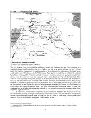
PPT-3500-2000 B.C. Southern end of the Tigris & Euphrates River (Fertile
Author : calandra-battersby | Published Date : 2018-03-18
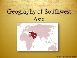
Crescent The Sumerians First people known to live in the Fertile Crescent They farmed and raised cattle Built large cities They invented the arch The Ziggurat a
Presentation Embed Code
Download Presentation
Download Presentation The PPT/PDF document "3500-2000 B.C. Southern end of the Tigri..." is the property of its rightful owner. Permission is granted to download and print the materials on this website for personal, non-commercial use only, and to display it on your personal computer provided you do not modify the materials and that you retain all copyright notices contained in the materials. By downloading content from our website, you accept the terms of this agreement.
3500-2000 B.C. Southern end of the Tigris & Euphrates River (Fertile: Transcript
Download Rules Of Document
"3500-2000 B.C. Southern end of the Tigris & Euphrates River (Fertile"The content belongs to its owner. You may download and print it for personal use, without modification, and keep all copyright notices. By downloading, you agree to these terms.
Related Documents