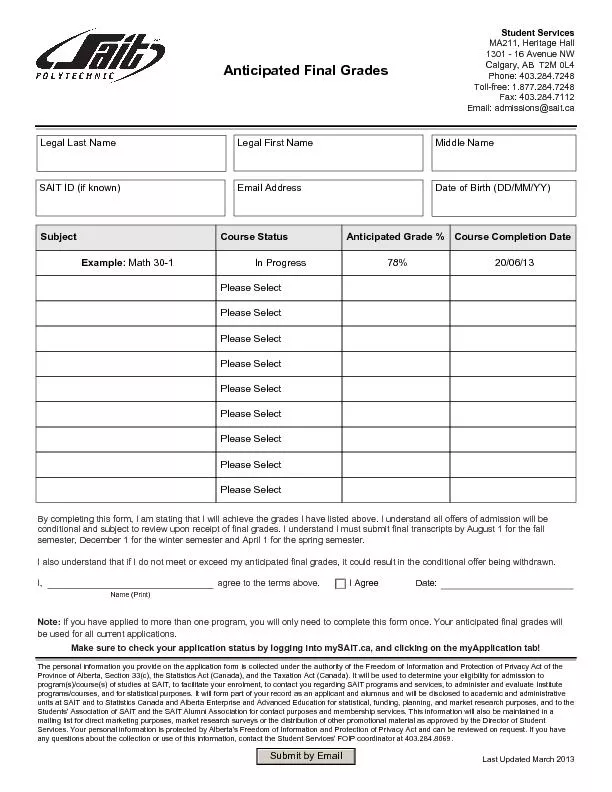
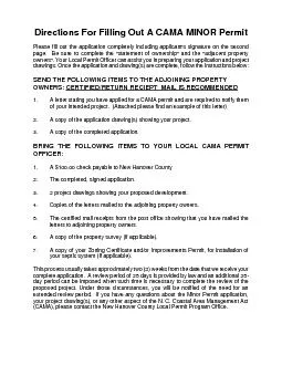
/
Directions For Filling Out A CAMA MINOR Permit Please fill out the app Directions For Filling Out A CAMA MINOR Permit Please fill out the app

Directions For Filling Out A CAMA MINOR Permit Please fill out the app - PDF document

deborah
deborah . @deborah
Follow
344 views
Uploaded On 2021-06-14

Directions For Filling Out A CAMA MINOR Permit Please fill out the app - PPT Presentation

SEND THE FOLLOWING ITEMS TO THE ADJOINING PROPERTY OWNERS CERTIFIEDRETURN RECIEPT MAIL IS RECOMMENDED PROJECT DRAWINGS All drawingsshould be drawn to scale ie 120 130 and includ ID: 842070

permit property project application property permit application project aec water area cama adjacent address normal owner hazard proposed drawing

Share:

Link:

Embed:

Download Presentation from below link

Download Pdf The PPT/PDF document "Directions For Filling Out A CAMA MINOR ..." is the property of its rightful owner. Permission is granted to download and print the materials on this web site for personal, non-commercial use only, and to display it on your personal computer provided you do not modify the materials and that you retain all copyright notices contained in the materials. By downloading content from our website, you accept the terms of this agreement.


Presentation Transcript

1 Directions For Filling Out A CAMA MINOR
Directions For Filling Out A CAMA MINOR Permit Please fill out the application completely including applicant's signature on the second page. Be sure to complete the "statement of ownership" and the "adjacent property SEND THE FOLLOWING ITEMS TO THE ADJOINING PROPERTY OWNERS: CERTIFIED/RETURN RECIEPT MAIL IS RECOMMENDED PROJECT DRAWINGS All drawingsshould be drawn to scale (ie. 1”=20’, 1”=30’) and include the following information: Name, project address, date and drawing scale (title box). Property dimensions and names of adjacent property owners indicated Dimensions and location of all existing and proposed structures, driveways, and sewage disposal system (attach Improvements Permit, if applicable). Decks labeled as covered or uncovered and dimensions shown. Adjacent water body labeled and Normal High Water (NHW) or Normal Water Level (NWL) contour shown. Marsh and/or wetland areas labeled (wetland delineation documentation from USACOE Army Corps of Engineers must be included with the application, if applicable). All areas of ground disturbance and/or landscaping shown. If your project is in the Ocean Hazard Area, your application must include an AEC Hazard Notice, signed by the property owner. Additional information for project drawings in the Ocean Hazard Area AECs includes:Show all dunes and dune system contours, labeling the dune crest and both the landward and oceanward dune toes. Also, include spot elevations on the highest portion of the dunes. The first line of stable, natural vegetation as flagged by the LPO and the applicable setback from the vegetation line. Contact the Local Permit Officer to stake the vegetation line for you if necessary. Cross-sectional/Elevation drawings showing the number of floors and the roof and deck profiles of the proposed structure(s). Add

2 itional drawing(s) for each floor plan m
itional drawing(s) for each floor plan may be necessary. List the Total Enclosed Floor Area. Total Enclosed Floor Area is the combined square-footage of all of the floors, plus any roof covered porches. Additional information for project drawings in the Coastal Shoreline AECs:Dimensions of the footprint/roofline of all structures (outside walls + roof overhang extended to the ground). Dimensions of all decks, labeled either covered or open (all elevated decks with concrete below them at ground level are considered impervious). Normal high water (NHW) or normal water level (NWL) contour. Show the applicable Area of Environmental Concern (AEC); 75 feet landward of normal high water (NHW) or normal water level (NWL) for Estuarine Shoreline AEC (Coastal or Joint Waters); or 575 feet landward of normal high water (NHW) or normal water level (NWL), if adjacent to Outstanding Resource Waters; or 30 feet landward of normal high water (NHW) or normal water level (NWL), if adjacent to Public Trust Shoreline (Inland Waters). List the total amount (sqft) of impervious surface that will be created from your proposed development. Show the 30-ft. buffer landward of normal high water (NHW) or normal water level (NWL) FILLING OUT THE APPLICATION FORM The shaded area at the top of the first page is completed by the Local Permit Officer. The LPO will assign a permit application number and check the AEC in which the property is located. In the general information section, the applicant and future permittee is always the Land Owner, although an agent, such as a contractor or realtor, may obtain the permit for the property owner. The applicant’s mailing address is entered here. If an agent is utilized to apply for the permit, their contact information is entered in the Authorized Agent section. Location of

3 Project is the address of property where
Project is the address of property where the work is to take place (the 911 address, subdivision and lot number, State or County road, etc.). Description of Project should include all land clearing, demolition, construction, and landscaping activities that are proposed to complete the project. It is better to go over-board here, than to omit something that would necessitate having to modify or re-apply for another permit to complete the development. Size of Lot/Parcel can be listed as square feet or acres, or both. Check the applicable Proposed Use, residential (single-family or multi-family), commercial, or other. The Total Enclosed Floor Area of a Building in the Ocean Hazard AEC section is only completed for those projects that are located in one or more of the Ocean Erodible, High Hazard Flood, Inlet Hazard or Unvegetated Beach AECs. Total Enclosed Floor Area is the combined square-footage of all of the floors, plus any roof covered porches. If the project is not in the Ocean Hazard Area, then insert N/A and go to the next section and determine in which Coastal Shoreline AEC the project is located. The Size of Building Footprint and Other Impervious Surfaces/Built-Upon Surfaces in the Coastal Shoreline AEC is calculated by totaling all of the impervious surfaces within the applicable distance (30 ft., 75 ft. or 575 ft.) from Normal High Water (NHW) or Normal Water Level (NWL). Sometimes the impervious surfaces that are allowed on an individual lot are further limited by the conditions of the subdivision’s State Stormwater Management Permit. The applicant should insert the amount of impervious coverage that is allocated to their lot under their subdivision’s State Stormwater Permit. This number is usually found on the property deed or subdivision covenants. Typically, any subdivi

4 sion that was developed after January 1,
sion that was developed after January 1,1988, will have a State Stormwater Plan. On tsecond page of the applicationthe section entitled Statement of Ownership is completed by the applicant using information from the property deed. The applicant must check one of the three options and fill in the appropriate information. Make sure that adjacent riparian property owners have been listed in the Notification of Adjacent Property Owners section that they have been contacted by the applicant, either in person or by certified mail. Copies of the completed letters certified mail receipts, if required, should accompany the applicationFinally, the applicant/agent must sign and date the application at the bottom of the page. Adjacent Property OwnerMailing Address City, State, Zip Code Dear Adjacent Property: This letter is to inform you that I, have applied for a CAMA Minor Property Owner Permit on my property at ________________________________________________________, in New Hanover Property Address County. As required by CAMA regulations, I have enclosed a copy of my permit application and project drawing(s) as notification of my proposed project. No action is required from you or you may sign and return the enclosed no objection form. If you have any questions or comments about my proposed project, please contact me at ______________________________ ,or by mail at the address listed below. If you wish to Applicant’s Telephonefile written comments or objections with the New Hanover CountyCAMA Minor Permit Program, you may submit them to: CAMA Local Permit Officer Local Permit Officer for New Hanover County 230 Government Center Drive, Suite 110 Zoning Division Wilmington, NC 28403 Sincerely,Proper

5 ty OwnerMailing AddressCity, State, Zip
ty OwnerMailing AddressCity, State, Zip Code Receipts for Certified Mail (Staple Here) ADJACENT RIPARIAN PROPERTY OWNER STATEMENT FOR CAMA MINOR PERMITSI hereby certify that I own property adjace_____________________________________'s (Name of Property Owner)property located at ______________________________________________________________, Address, Lot, Block, Road, etc.)_______________________________________, N.C.(Waterbody) (Town and/or County)He has described to me as shown in the attached application and project drawing(s), the development he is proposing at that location, and, I have no objections to his proposal. (APPLICATION AND DRAWING OF PROPOSED DEVELOPMENT ATTACHED) Signature Print or Type Name Telephone Number Date Adjacent Property OwnerMailing Address City, State, Zip Code Dear Adjacent Property: This letter is to inform you that I, have applied for a CAMA Minor Property Owner Permit on my property at ________________________________________________________, in New Hanover Property Address County. As required by CAMA regulations, I have enclosed a copy of my permit application and project drawing(s) as notification of my proposed project. No action is required from you or you may sign and return the enclosed no objection form. If you have any questions or comments about my proposed project, please contact me at ______________________________ ,or by mail at the address listed below. If you wish to Applicant’s Telephonefile written comments or objections with the New Hanover County CAMA Minor Permit Program, you may submit them to: CAMA Local Permit Officer Local Permit Officer for New Hanover County 230 Government Center Drive, Suite 110 Zoning Division

6 Wilmington, NC 28403 Sincerely,Propert
Wilmington, NC 28403 Sincerely,Property OwnerMailing AddressCity, State, Zip Code Receipts for Certified Mail (Staple Here) ADJACENT RIPARIAN PROPERTY OWNER STATEMENT FOR CAMA MINOR PERMITSI hereby certify that I own property adjacent to _____________________________________'s (Name of Property Owner)property located at ______________________________________________________________, Address, Lot, Block, Road, etc.), N.(Waterbody) (Town and/or County)He has described to me as shown in the attached application and project drawing(s), the development he is proposing at that location, and, I have no objections to his proposal. (APPLICATION AND DRAWING OF PROPOSED DEVELOPMENT ATTACHED) Signature Print or Type Name Telephone Number Date AGENT AUTHORIZATION FOR CAMA PERMIT APPLICATION Name of Property Owner Requesting Permit : _________________________________ Mailing A ddress: ______________________________________________ ______________________________________________ P hone Number: ______________________________________________ Email Address: ______________________________________________ I certify that I have authorized _____________________________________________, Agent / Contractor to act on my behalf, for the purpose of applying for and obtaining all CAMA permits necessary for the following proposed development: ___________________________ at m y property located at _________________________________________________ , i

7 n ________________ County. I furthe
n ________________ County. I furthermore certify that I am authorized to grant, and do in fact grant permission to Division of Coastal Man agement s taff, the Local Permit Officer and their agents to enter on the aforementioned lands in connection with evaluating information related to this permit application. Property Owner Information : _ ___________________________________ Signature ____________________________________ Print or Type Name ____________________________________ Title ______ / _______ / ________ Date This certification is valid through ______ / _______ / ________ Locality ______________________________________________________ Permit Number ___________ Ocean Hazard Estuarine Shoreline _____ORW Shoreline _____Public Trust ShorelineOther_____ (For official use only) GENERAL INFORMATION LAND OWNER Name: __________________________________________________________________________________________ Address: ________________________________________________________________________________________ City:_____________________________ State:______ Zip:___________ _______________________ AUTHORIZED AGENT Name: __________________________________________________________________________________________ Address: _________________________________________________________________________________________ City:______________________________ State:_______ Zip:___________ _______________________ LOCATION

8 OF PROJECT: (Address, street name and/or
OF PROJECT: (Address, street name and/or directions to site. If not oceanfront, what is the name of the adjacent waterbody.) ________________________________________________________________________________ DESCRIPTION OF PROJECT: (List all proposed construction and land disturbance.) __________________________ SIZE OF LOT/PARCEL: ______________square feet ____________acres PROPOSED USE: Residential ____ (Single-family _Multi-family) Commerical/Industrial ____ Other ____ TOTAL ENCLOSED FLOOR AREA OF A BUILDING IN THE OCEAN HAZARD AREA OF ENVIRONMENTAL CONCERN (AEC): ______________square feet (includes all floors and roof covered decks)SIZE OF BUILDING FOOTPRINT AND OTHER IMPERVIOUS OR BUILT-UPON SURFACES IN THE COASTAL SHORELINE AREA OF ENVIRONMENTAL CONCERN (AEC): _______________square feet(Calculations includes the area of the roof/drip line of all buildings, driveways, covered decks, concrete or masonry patios, etc. that are within the applicable AEC.)(Attach your calculations with the project drawing.) Choose the AEC area that applies to your property: (1) within 75 feet of Normal High Water for the Estuarine Shoreline AEC (2) within 575 feet of Normal High Water for the Estuarine Shoreline AEC, adjacent to Outstanding Resource Waters (3) within 30 feet of the Public Trust Shoreline AEC (Contact your Local Permit Officer if you are not sure which AEC applies to your property.) STATE STORMWATER MANAGEMENT PERMIT: Is the project located in an area subject to a State Stormwater Management Permit issued by the NC Division of Water Quality? YESNO ___ If yes, list the total built upon area/impervious surface allowed for your lot or parcel. ________________ square feet. NEW HANOVER COUNTY OTHER PERMITS MAY BE REQUIRED: The activity you are planning may require permits other tha

9 n the CAMA minor development permit. As
n the CAMA minor development permit. As a service we have compiled a listing of the kinds of permits that might be required. We suggest you check over the list with your LPO to determine if any of these apply to your project. Zoning, Drinking Water Well, Septic Tank (or other sanitary waste treatment system), Building, Electrical, Plumbing, Heating and Air Conditioning, Insulation and Energy Conservation, FIA Certification, Sand Dune, Sediment ControlSubdivision Approval, Mobile Home Park Approval, Highway Connection, and others. STATEMENT OF OWNERSHIP: I, the undersigned, an applicant for a CAMA minor development permit, being either the owner of property in an AEC or a person authorized to act as an agent for purposes of applying for a CAMA minor development permit, certify that the person listed as landowner on this application has a significant interest in the real property described therein. This interest can be described as: (check one) an owner or record title, Title is vested in_________________________, see Deed Book _____________________ page __________ in the _______________________________ County Registry of Deeds. an owner by virtue of inheritance. Applicant is an heir to the estate of_____________________________________; probate was in ________________________________________ County. if other interest, such as written contract or lease, explain below or use a separate sheet and attach to this application.___________________________________________________________________________________________________________________________________________________________________________________________ NOTIFICATION OF ADJACENT PROPERTY OWNERS: I furthermore certify that the following persons are owners of properties adjoining this property. I affirm that I have given ACTUAL NOTICE to each of th

10 em concerning my intent to develop this
em concerning my intent to develop this property and to apply for a CAMA permit. (Name) (Address) (1)____________________________________________________________________________________________ (2)____________________________________________________________________________________________ (3)____________________________________________________________________________________________ (4)____________________________________________________________________________________________ FOR DEVELOPERS IN OCEAN HAZARD AND ESTUARINE HAZARD AREAS: I acknowledge that the land owner is aware that the proposed development is planned for an area which may be susceptible to erosion and/or flooding. I acknowledge that the local permit officer has explained to me the particular hazard problems associated with this lot. This explanation was accompanied by recommendations concerning stabilization and floodproofing techniques. PERMISSION TO ENTER ON LAND: I furthermore certify that I am authorized to grant and do in fact grant permission to the local permit officer and his agents to enter on the aforementioned lands in connection with evaluating information related to this permit application. This application includes: general information (this form), a site drawing as described on the back of this application, the ownership statement, the AEC hazard notice where necessary, a check for $100.00 made payable to the locality, and any information as may be provided orally by the applicant. The details of the application as described by these sources are incorporated without reference in any permit which may be issued. Deviation from these details will constitute a violation of any permit. Any person developing in an AEC without permit is subject to civil, criminal and administrative action.

11 This theday of______________________
This theday of_______________________ Landowner or person authorized to act as his agent for purpose of filing a CAMA permit application SITE DRAWING/APPLICATION CHECKLIST Please make sure your site drawing includes the following information required for a CAMA minor development permit. The drawing may be simple and not necessarily to scale. The Local Permit Officer will help you, if requested. PHYSICAL DIMENSIONS Label roads Label highways right-of-ways Label local setback lines Label any and all structures and driveways currently existing on property PHYSICAL CHARACTERISTICS Draw and label mean high water mark Draw location of on-site wastewater system If you will be working in the ocean hazard area: Draw and label dune ridges (note height) Draw and label toe of dune Identify and locate first line of stable vegetation Draw and label setback line under CAMA Draw and label topographical features (optional) If you will be working in an estuarine shoreline area: Draw and label landward limit of AEC Describe terrain (slope) DEVELOPMENT PLANS Draw and label areas that will be disturbed If a house is to be placed on lot, describe location of house Note size of piling and depth to be placed in ground Draw and label all areas to be paved or graveled Describe composition of surface Note and list fully all trees and vegetation to be removed or relocated Show landscaping NOTE TO APPLICANT Have you: completed all blanks and / or indicated if not applicable? notified and listed adjacent property owners? included your site drawing? signed both application and statement of ownership? enclosed the $100.00 fee? completed an AEC Hazard Notice, if necessary? FOR STAFF USE Site Notice Posted Final Inspection Fee Received Site InspectionsDate of Action: Issued Exempted Denied Appeal Deadline