/
1.5		Understand how 1.5		Understand how

1.5 Understand how - PowerPoint Presentation

min-jolicoeur
min-jolicoeur . @min-jolicoeur
Follow
380 views
Uploaded On 2016-07-18

1.5 Understand how - PPT Presentation

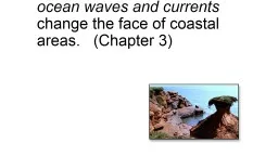
ocean waves and currents change the face of coastal areas Chapter 3 Hydraulic ActionPressure air being forced into crack in rocks Corrosion Solution Minerals such as calcium carbonate amp limestone dissolve in the water ID: 409062

beach bay sea spit bay beach spit sea sand water action form bar land hydraulic amp air drift waves

Share:

Link:

Embed:

Download Presentation from below link

Download Presentation The PPT/PDF document "1.5 Understand how" is the property of its rightful owner. Permission is granted to download and print the materials on this web site for personal, non-commercial use only, and to display it on your personal computer provided you do not modify the materials and that you retain all copyright notices contained in the materials. By downloading content from our website, you accept the terms of this agreement.


Presentation Transcript

Slide1

1.5 Understand how ocean waves and currents change the face of coastal areas. (Chapter 3)Slide2

Hydraulic Action/Pressure - air being forced into crack in rocks.

Corrosion (Solution)

Minerals such as calcium carbonate & limestone dissolve in the water

Abrasion

rock & sand particles suspended in the water bump, grind, scrape & gouge surfaces the water hitsSlide3

Hydraulic ActionHydraulic action is a form of

mechanical weathering

Caused by the force of moving

water currents rushing into a crack in the rockface. The water compresses the air in the crack, pushing it right to the back. As the wave retreats, the highly pressurized air is suddenly released with explosive forceCapable of chipping away the rockface over time. Slide4

Hydraulic ActionSlide5

Emerging vs. Submerging CoastlinesEmerging

Caused by lowering water levels and/or rising land level

Land “springing up after glacier is gone.

Steep land features, cliffs etc.

SubmergingCaused by RISING sea levelsWere once river valleys now submergedResults in more sand from deltas and/or outwash plainsLower, gradual slopeSlide6

Define the terms

bay beach

bay bar

spit

(P. 44-45)Slide7

Bay BeachSmall beach of sand found between two peninsulas or headlands

An accumulation of sediment deposited by waves and longshore drift along a bay.Slide8

Bay Beach – Bonne BaySlide9

Bay BeachSlide10

Spit

Ridge of sand projecting from the land into a body of water

usually with a curved seaward end.

Spit grows in the prevailing direction of longshore drift.

Ends are curved by the action of waves in different directionsSlide11

SpitSlide12

SpitWhat can you tell about the direction of long shore drift?

Is there any indication a bay bar might form?

Sandy Point Newfoundland!Slide13

Spit - CaliforniaSlide14
Slide15

Bay BarA ridge of mud, sand or silt extending across a bay.

Formed when spits stretch across the mouth of the bay

Notice the spit has

closed off the mouth of the harbor/bayWould these be a tourist attraction or distraction?Slide16

Bay BarSlide17

Goodyear’s Cove, South Brook, NL. ?Slide18

Bay Beach

2. The point of land on top of the picture would be called?

Where does all the beach sand come from? Can you propose two sources?Slide19

Define the terms

bay beach

bay bar

spit

(P. 44-45)Are these landforms caused by erosion or weathering?Slide20

Describe how sea caves, sea arches and sea stacks are formed. (P. 48)

These three coastal structures occur on “emerging” coast lines with steep cliffs & a headland.

1

st

Sea caves form , 2

nd

sea arches form and 3rd sea stacks form.