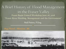
Fraser River Flooding Management and the Environment A Brief History of Flood Management in the Fraser Valley Neil Peters PEng 1894 Flood Mission BC The Lower Fraser Floodplain ID: 807652
Download The PPT/PDF document "Fraser Basin Council Workshop June 26, 2..." is the property of its rightful owner. Permission is granted to download and print the materials on this web site for personal, non-commercial use only, and to display it on your personal computer provided you do not modify the materials and that you retain all copyright notices contained in the materials. By downloading content from our website, you accept the terms of this agreement.
Slide1
Fraser Basin Council Workshop June 26, 2018“Fraser River Flooding, Management and the Environment”
A Brief History of Flood Management in the Fraser Valley
Neil Peters, P.Eng.
1894 Flood – Mission , BC
Slide2The Lower Fraser Floodplain
Historic Floods and Societal Response18941948
1972Legislative Change 2003Updated Design Flood Profile 2006Managing Flood Risk – Where are we today?
Outline
Slide375,000 hectares protected by approx 500 km of dikes 500,000 people in floodplain; over 2 million people depend on infrastructure
re-occurrence of 1894 flood would cause tens of billions of dollars damage
Lower Fraser Dikes and Floodplain
Richmond
Chilliwack
Slide4New Westminster, early 1860s
Slide5Fraser River Hydrographs at Hope
1894
peak flow 17,000 m3/s
1948
2018
1972
Slide6Chilliwack 1894
Slide7Fraser Valley, 1876
Slide8Dredge
Col. Tobinat work “reclaiming” Sumas Lake 1921
Slide91948 Fraser River Flood
Looking West over Nicomen Island to the Cities of Abbotsford and Mission
Slide101948 Flood
Looking West from Agassiz
Peak Flow Attenuation by Floodplain Storage
Harrison Lake
Slide11Dike 1948
Fraser River Dikes Rebuilt
Dike after 1948
Slide12The Fraser River Flood Control Program
1968 to 1994
Slide13Fraser River Board Upstream Storage Studies
In both 1963 and 1976 the Board recommended upstream dams and diversions
Diking alone not sufficient protection
But major impacts of dams on parks and environment
The McGregor
Diversion to the Peace R.
Slide14Floodplain Development Control Program (1975-2003)
Oak Hills Subdivision - 1972 Flood North Thompson River
The Oak Hills Dike
Reconstructed
Slide15Floodproofing with Fill - Delta
Design Flood Level
Slide16Floodplain Management Legislative Changes 2003
Repealed legislation requiring provincial involvement in floodplain development regulation.Shifted responsibilities for floodplain land use decisions to local governmentsPublished the 2004 “Flood Hazard Area Land Use Management Guidelines”
Updated Design Flood Profile 2006 (2008 and 2014)Typically one metre higher than 1969 profile used by Fraser River Flood Control ProgramWhy?– new surveying and computer tools accurately model diked channel geometry
Implication – most dikes likely to fail if recurrence of 1894 flood
Slide17Last Damaging Lower Fraser Flood was 1948
Limited societal memory, relatively low political priority.No current equivalent to former “Fraser River Board”Increasing Flood Risk on Lower FraserIncreasing population and development in floodplain
Major limitations to existing dikes, challenges to upgrade, including land costs and geotechnical design. Potential for increased flows and levels due to climate change (and sea level rise effects downstream of Mission) .But There is Hope!
Rising flood disaster costs in other provinces have triggered renewed efforts on mapping, flood insurance and mitigationLower Fraser Flood Strategy – FBC and Partners
Managing Flood Risk – Where Are We Today?
Slide18Thank You!