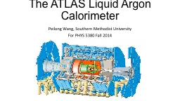
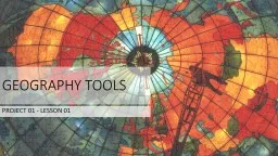
PPT-Atlas A book of maps and facts about geography.

Author : roxanne | Published Date : 2024-01-03

The Complete Library Skills Atlas Vocabulary Legend and Scale They help you read a map A legend or key will tell you what the colored areas mean and what the

Presentation Embed Code

Download Presentation

Download Presentation The PPT/PDF document "Atlas A book of maps and facts about g..." is the property of its rightful owner. Permission is granted to download and print the materials on this website for personal, non-commercial use only, and to display it on your personal computer provided you do not modify the materials and that you retain all copyright notices contained in the materials. By downloading content from our website, you accept the terms of this agreement.

Atlas A book of maps and facts about geography.: Transcript


The Complete Library Skills Atlas Vocabulary Legend and Scale They help you read a map A legend or key will tell you what the colored areas mean and what the symbols stand for The scale . By: Ashley . Lenar. GLCE. 1 – G1.0.1 Construct simple maps of the classroom to demonstrate aerial perspective.. 1 – G1.0.2 Give examples of places that have absolute locations (e.g. home address, school address). November 15-21, 2015. Explore! The Power of Maps. About Me. Tama Nunnelley. 6th-8th Grade SS at Guntersville Middle School, Guntersville, Alabama. Alabama Geographic Alliance, National Council Geographic . PROJECT 01 - LESSON 01. WHAT ARE THE DIFFERENT TYPES OF TOOLS GEOGRAPHERS USE?. Geographers use all sorts of tools to help them investigate their questions. They commonly use maps, globes, atlases, aerial photographs, satellite photographs, information graphics, and a computer program called GIS. . Def. : the study of Earth and its people. View the world in . SPATIAL . terms (how are things arranged in space relative to each other). Geo. is divided into 2 major branches…. geography. Def. : the study of natural features on the surface of Earth. COMPASS ROSE AND DIRECTIONS. When reading a map it’s always important to know your directions. The Compass Rose is the tool to help you do that. . Map directions are broken down into 2 main types; Cardinal Directions and Intermediate Directions. Chapter 2. Lesson 1. Studying Geography. Physical maps show land and water features.. Studying Geography. Political maps show the names and borders of countries.. Studying Geography. Special purpose maps show patterns such as climate, natural resources, or population.. a. Locate on a world and regional political-physical map: the Sahara, Sahel, savanna, tropical rain forest, Congo River, Niger River, Nile River, Lake Tanganyika, Lake Victoria, Atlas Mountains, and Kalahari Desert. . An Interactive Presentation. Chapter 1, Section 1. What is Geography?. Geography. is the study of people, their environments, and their resources.. Chapter 1, Section 1. The Five Themes of Geography. Before We Begin . . .. SWBAT/Aim:. Illustrate . what is geography and how can knowing geographic features of the world help you on the Regents exam?. Do Now:. . First:. . Copy the Aim, Date, Homework below.. 147YOU146RE A COLLEGE PROFESSORraphy148 I146ll hear something like 147Oh I loved geography in school I memorized all the mountain ranges and rivers in India148 or 147I have a you keep up with all tho The Sky Atlas unveils some of the most beautiful maps and charts ever created during humankind\'s quest to map the skies above us. This richly illustrated treasury showcases the finest examples of celestial cartography—a glorious art often overlooked by modern map books—as well as medieval manuscripts, masterpiece paintings, ancient star catalogs, antique instruments, and other curiosities. This is the sky as it has never been presented before: the realm of stars and planets, but also of gods, devils, weather wizards, flying sailors, ancient aliens, mythological animals, and rampaging spirits. • Packed with celestial maps, illustrations, and stories of places, people, and creatures that different cultures throughout history have observed or imagined in the heavens• Readers are taken on a tour of star-obsessed cultures around the world, learning about Tibetan sky burials, star-covered Inuit dancing coats, Mongolian astral prophets and Sir William Herschel\'s 1781 discovery of Uranus, the first planet to be found since antiquity.• A gorgeous book that delights stargazers and map lovers alikeWith thrilling stories and gorgeous artwork, this remarkable atlas explores our fascination with the sky across time and cultures to form an extraordinary chronicle of cosmic imagination and discovery.The Sky Atlas is a wonderful book for map lovers, history buffs, and stargazers, but also for those who are intrigued by the many wonderful and bizarre ways in which humans have sought to understand the cosmos and our place in it.• A unique map book that expands beyond the terrestrial and into the celestial• A wonderful gift for map lovers, obscure-history fans, mythology buffs, and astrology and astronomy lovers• Great for those who enjoyed What We See in the Stars: An Illustrated Tour of the Night Sky by Kelsey Oseid, Maps by Aleksandra Mizielinska and Daniel Mizielinski, and Atlas of Remote Islands: Fifty Islands I Have Never Set Foot On and Never Will by Judith Schalansky The Student Atlas series combines full-color maps and data sets to introduce students to the importance of the connections between geography and other areas of study such as world politics, environmental issues, and economic development. These thematic atlases will give students a clear picture of the recent agricultural, industrial, demographic, environmental, economic, and political changes in every world region. In this revelatory new book, Marshall explores ten regions that are set to shape global politics in a new age of great-power rivalry: Australia, Iran, Saudi Arabia, the UK, Greece, Turkey, the Sahel, Ethiopia, Spain and Space. Find out why Europe’s next refugee crisis is closer than it thinks as trouble brews in the Sahel why the Middle East must look beyond oil and sand to secure its future why the eastern Mediterranean is one of the most volatile flashpoints of the twenty-first century and why the Earth’s atmosphere is set to become the world’s next battleground. Governance. February 2020. Background. One of the main aims of Realistic Medicine is to tackle . unwarranted variation. . Variation in healthcare that cannot be explained by need, or by explicit patient or population preferences is referred to as unwarranted variation. .

Download Document

Here is the link to download the presentation.
"Atlas A book of maps and facts about geography."The content belongs to its owner. You may download and print it for personal use, without modification, and keep all copyright notices. By downloading, you agree to these terms.

Related Documents