Explore
Featured
Recent
Articles
Topics
Login
Upload
Featured
Recent
Articles
Topics
Login
Upload
Search Results for 'Consortium-Geospatial'
Consortium-Geospatial published presentations and documents on DocSlides.
Copyright © 2017 Open Geospatial Consortium
by luanne-stotts
. Copyright © 2017 Open Geospatial Consortium. ...
A Vision for an Exchangeable
by tatyana-admore
UxS. Mission Plan. Scott Simmons. Executive Dire...
Consortium for Children Consortium for Children, Copyright 2018
by emery
Be Proud, Georgia!. Consortium for Children, Copyr...
Geospatial Platform Update
by isaac463
NGAC Meeting. December 7, 2010. Karen Siderelis. G...
NGAC Geospatial Workforce Development Subcommittee
by osiris
Subcommittee Members. Dave DiSera (Chair). Joanne ...
NGAC Geospatial Partnerships with Tribes
by westley354
Chair: . David Wyatt. Members:. . J. Johnston, ...
GDRS and you! Geospatial Data Resource Sites
by leah
Tim Loesch, MN DNR. Presentation to the . Statewid...
Geospatial Analysis and Modeling - NCSU MEAS – Helena Mitasova
by ivy
Geomorphometry I: . Terrain modeling. Geospatial A...
EVOLUTION OF THE BCC GEOSPATIAL CENTER OF THE
by angelina
CUNY CREST INSTITUTE (2010-). Growth of the BCC Ge...
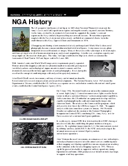
The US geospatial intelligence effort began in 1803 when President Tho
by callie
On 21 June 1956 President Eisenhower ordered the c...
Welcome to the VCCS Geospatial Institute
by scoopulachanel
With support from:. NSF DUE-0903270. Hosted by the...
September 23, 2015 Statewide Geospatial Advisory Council
by briana-ranney
Call to order and . introductions. Approval . of ...
Integrating Official Statistics and Geospatial Information
by danika-pritchard
– ABS experience . Frank Yu. First Assistant St...
Geospatial Data Abstraction Library (GDAL) Enhancement for
by giovanna-bartolotta
). Increasing . Accessibility and Interoperabilit...
Free and Open Source Geospatial Software and Data
by tawny-fly
Ioannis. . Kokkinidis. Geospatial and Environmen...
The X3D Geospatial Component: X3DOM implementation of
by alexa-scheidler
GeoOrigin. , . GeoLocation. , . GeoViewpoint. , a...
© 2011
by alida-meadow
Open Geospatial Consortium, Inc.. FAA Special Act...
Foundation Fighting Blindness (FFB) Consortium Overview
by naomi
. Last Updated: April 17, 2020. Foundation Fightin...
LAND POOLING PROCEDURE Consortium will prepare an
by phoebe
Implementation Plan . in consultation with all con...
Student Fellowships FAQ Cooperative Consortium for Transdisciplinary Social Justice Research
by opelogen
Cooperative Consortium for Transdisciplinary Socia...
INDIGO – DataCloud The Consortium
by backbays
Indigo-. DataCloud. kick-off meeting. Bologna, Ap...
Title I, Part C Migrant Education Program Consortium
by tatyana-admore
Georgia Migrant Consortium Districts’ Responsib...
Student Fellowships FAQ Cooperative Consortium for Transdisciplinary Social Justice Research
by karlyn-bohler
Cooperative Consortium for Transdisciplinary Soci...
Copyright 2018 Disciplined Agile Consortium
by myesha-ticknor
2018 IT Success Rate. Survey . Results. Scott W. ...
Disciplined DevOps © Disciplined Agile Consortium
by conchita-marotz
. 1. © Disciplined Agile Consortium. 2. Agenda....
Event Consortium 10-31-17
by celsa-spraggs
Event Consortium Reserve. Ball Annex – South of...
Digital Stationery Consortium
by kittie-lecroy
Confidential. All Rights Reserved. Copyright © 2...
ABOUT STUDENTS REGIONAL CONSORTIUM
by tatyana-admore
Fiscal Informational Meeting October 5, 2016. Age...
2018 Presenter Consortium for Jazz
by cheryl-pisano
Deadline: October . 1. , 2017, Midnight, ET. Noti...
Sierra Joint Consortium
by conchita-marotz
Summit on Adult Education. Bridging the Gap. Summ...
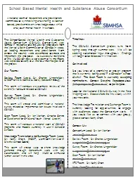
School Based Mental Health and Substance Abuse Consortium
by yoshiko-marsland
The School-Based Mental Health and Substance Abus...
2017 Presenter Consortium for Jazz
by calandra-battersby
Deadline: October 30, 2016, Midnight, ET. Notific...
The Oncofertility Consortium
by giovanna-bartolotta
At Northwestern University. Current status and fu...
2016 Presenter Consortium for Jazz
by lois-ondreau
Deadline: Friday, October 30, 2015, Midnight, ET....
Statewide Geospatial Advisory council November 28,
by tatyana-admore
Statewide Geospatial Advisory council November 28,...
The Cloud Services Innovation Platform:
by jaxon
Platform:. Enabling Service Based Environmental . ...
Geospatial Portfolio Management, Theme Lead and Dataset Manger Roles and Responsibilities, and the Investment Collaboration Process
by rudy
Theme Lead and Dataset Manger Roles and Responsibi...
Midyear Meeting National States Geographic Information Council
by elise
Review of NSGIC Midyear Meeting. Feb 27 – Mar 2,...
Adding Value to Registries through Geospatial Big Data Fusion
by angelina
Geospatial Health Context Big Table . Facilitating...
GLOBAL NEAR-REAL-TIME INTERDISCIPLINARY
by megan
GEOSPATIAL DATA DEVELOPMENT,. ANALYSIS, ARCHIVING,...
Load More...