/
City of Satellite Beach City of Satellite Beach

City of Satellite Beach - PowerPoint Presentation

trish-goza
trish-goza . @trish-goza
Follow
429 views
Uploaded On 2016-06-13

City of Satellite Beach - PPT Presentation

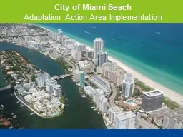
Satellite Beach Total area of 43 square miles Just over 10000 residents 98 built out More than half of the City is less than six feet above mean sea level and a quarter is less than four feet above mean sea level ID: 360000

satellite city planning sea city satellite sea planning beach florida level grant rise area protecting policy project environmental coastal

Share:

Link:

Embed:

Download Presentation from below link

Download Presentation The PPT/PDF document "City of Satellite Beach" is the property of its rightful owner. Permission is granted to download and print the materials on this web site for personal, non-commercial use only, and to display it on your personal computer provided you do not modify the materials and that you retain all copyright notices contained in the materials. By downloading content from our website, you accept the terms of this agreement.


Presentation Transcript

Slide1

City of Satellite BeachSlide2

Satellite Beach

Total

area of 4.3 square

milesJust over 10,000 residents98% built outSlide3

More than half of the City is less than six feet above mean sea level, and a quarter is less than four feet above mean sea level.

Total

water frontage of approximately 11.8

milesMuch of the Atlantic Shoreline is “Critically Eroded”Slide4

Satellite Beach Climate Ready Estuaries Pilot Project

2009 – 2010

Grant by U.S. Environmental Protection Agency 2009 Climate Ready Estuaries Program

Investigate and assess

the potential effects of sea level rise on the City’s infrastructure and resourcesEducation and OutreachSlide5

LiDAR

V

ertical datum NAVD88

Local adjustment based on Banana River data and SLR

Final Adjusted MWL(2010) -0.189mSlide6

2013

Adaptation Action Area Policy

Objective

1.12A - Development and redevelopment within the City shall be permitted only when consistent with sound planning practices that shall protect life and property from the effects of coastal erosion, flooding, sea level rise, or damage to environmental systems.Policy 1.12A.2 – The City of Satellite Beach designates the Adaptation Action Area (AAA) as that area which includes the CHHA and

other areas of the City as may be identified by the City Council in the future as being subject to coastal erosion, flooding, sea level rise, or damage to environmental systems.Slide7

Protecting Paradise

The City of Satellite Beach Community Resiliency ProjectSlide8

Protecting Paradise Overview

Florida Department of Protection Grant Program – Coastal Partnership Initiative

D

evelopment and implementation of AAA criteria and resiliency strategies for Satellite BeachSlide9

Project

Team

City of Satellite BeachEast Central Florida Regional Planning CouncilBrevard County Florida Institute of TechnologyFlorida Department of Economic OpportunityUF – Florida Sea Grant

City of Satellite Beach

East Central Florida Regional Planning Council

Brevard County

Volusia County

Florida Institute of Technology

Florida Department of Economic Opportunity

U.S Army Corps of Engineers – Planning and Policy Division

UF – Florida Sea Grant

UF -

GeoPlan

Space Coast TPO

River to Sea TPO

FDOT

NOAA – Melbourne Office

Environmental Remediation

Technical Advisory TeamSlide10

Protecting Paradise

Conducting Vulnerability and Risk Assessments

Flood

Storm SurgeErosionSea Level Rise

Atlantic Coast

Mean High High Water (NAVD88) USACE Low, Medium and High Projection Curves Planning Horizon: 2040, 2070, 2100Slide11

Public Kick-Off Meeting

Sept

. 23

Panel of SpeakersProject OverviewVulnerability OverviewAAA EducationPublic Engagement ActivitiesSlide12

Contact Information

Tara McCue, AICP

Director of Planning and Community Development

East Central Florida Regional Planning Counciltara@ecfrpc.org407-262-7772 ext. 327