
Monitoring the Ocean Improves Hurricane Intensity
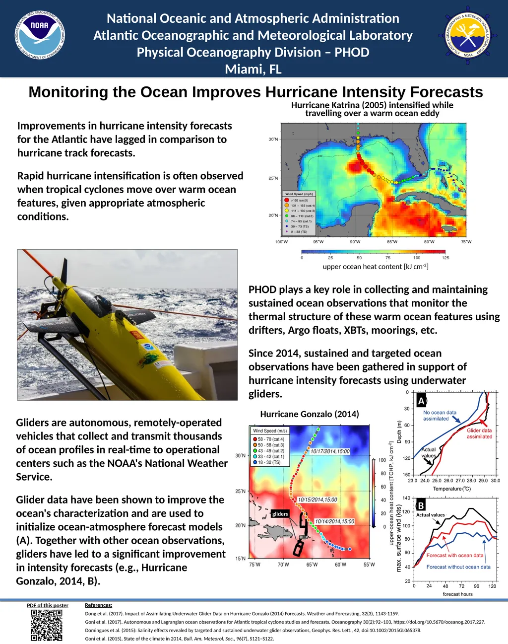
Description: Monitoring the Ocean Improves Hurricane Intensity Forecasts National Oceanic and Atmospheric Administration Atlantic Oceanographic and Meteorological Laboratory Physical Oceanography Division PHOD Miami, FL PHOD plays a key role in
Related Topics
Download Presentation
"Monitoring the Ocean Improves Hurricane Intensity" is the property of its rightful owner. Permission is granted to download and print the materials on this website for personal, non-commercial use only, and to display it on your personal computer provided you do not modify the materials and that you retain all copyright notices contained in the materials. By downloading content from our website, you accept the terms of this agreement.
Presentation Transcript
slide1. Monitoring the Ocean Improves Hurricane Intensity Forecasts National Oceanic and Atmospheric Administration
Atlantic Oceanographic and Meteorological Laboratory
Physical Oceanography Division – PHOD
Miami, FL PHOD plays a key role in collecting and maintaining sustained ocean observations that monitor the thermal structure of these warm ocean features using drifters, Argo floats, XBTs, moorings, etc.
Since 2014, sustained and targeted ocean observations have been gathered in support of hurricane intensity forecasts using underwater gliders. Gliders are autonomous, remotely-operated vehicles that collect and transmit thousands of ocean profiles in real-time to operational centers such as the NOAA's National Weather Service.
Glider data have been shown to improve the ocean's characterization and are used to initialize ocean-atmosphere forecast models (A). Together with other ocean observations, gliders have led to a significant improvement in intensity forecasts (e.g., Hurricane Gonzalo, 2014, B). PDF of this poster Hurricane Katrina (2005) intensified while travelling over a warm ocean eddy upper ocean heat content [kJ cm-2] Improvements in hurricane intensity forecasts for the Atlantic have lagged in comparison to hurricane track forecasts.
Rapid hurricane intensification is often observed when tropical cyclones move over warm ocean features, given appropriate atmospheric conditions. A B Actual values Hurricane Gonzalo (2014) References:
Dong et al. (2017). Impact of Assimilating Underwater Glider Data on Hurricane Gonzalo (2014) Forecasts. Weather and Forecasting, 32(3), 1143-1159.
Goni et al. (2017). Autonomous and Lagrangian ocean observations for Atlantic tropical cyclone studies and forecasts. Oceanography 30(2):92–103, https://doi.org/10.5670/oceanog.2017.227.
Domingues et al. (2015): Salinity effects revealed by targeted and sustained underwater glider observations, Geophys. Res. Lett., 42, doi:10.1002/2015GL065378.
Goni et al. (2015), State of the climate in 2014, Bull. Am. Meteorol. Soc., 96(7), S121–S122.<br>
Atlantic Oceanographic and Meteorological Laboratory
Physical Oceanography Division – PHOD
Miami, FL PHOD plays a key role in collecting and maintaining sustained ocean observations that monitor the thermal structure of these warm ocean features using drifters, Argo floats, XBTs, moorings, etc.
Since 2014, sustained and targeted ocean observations have been gathered in support of hurricane intensity forecasts using underwater gliders. Gliders are autonomous, remotely-operated vehicles that collect and transmit thousands of ocean profiles in real-time to operational centers such as the NOAA's National Weather Service.
Glider data have been shown to improve the ocean's characterization and are used to initialize ocean-atmosphere forecast models (A). Together with other ocean observations, gliders have led to a significant improvement in intensity forecasts (e.g., Hurricane Gonzalo, 2014, B). PDF of this poster Hurricane Katrina (2005) intensified while travelling over a warm ocean eddy upper ocean heat content [kJ cm-2] Improvements in hurricane intensity forecasts for the Atlantic have lagged in comparison to hurricane track forecasts.
Rapid hurricane intensification is often observed when tropical cyclones move over warm ocean features, given appropriate atmospheric conditions. A B Actual values Hurricane Gonzalo (2014) References:
Dong et al. (2017). Impact of Assimilating Underwater Glider Data on Hurricane Gonzalo (2014) Forecasts. Weather and Forecasting, 32(3), 1143-1159.
Goni et al. (2017). Autonomous and Lagrangian ocean observations for Atlantic tropical cyclone studies and forecasts. Oceanography 30(2):92–103, https://doi.org/10.5670/oceanog.2017.227.
Domingues et al. (2015): Salinity effects revealed by targeted and sustained underwater glider observations, Geophys. Res. Lett., 42, doi:10.1002/2015GL065378.
Goni et al. (2015), State of the climate in 2014, Bull. Am. Meteorol. Soc., 96(7), S121–S122.<br>